->

17 March 2010

Worldwide Telescope (WWT) now in Bing Maps

Worldwide Telescope (WWT) now in Bing Maps [Preview mode]

The Sky at night (and day) in Bing Maps Explore

With the new Bing Maps Worldwide Telescope (WWT) App you can explore the constellations and other known space objects just like you would navigate through a regular Bing Maps.Worldwide Telescope Preview in Bing Maps
To access this use the "Map Apps" and choose Worldwide Telescope

Drag Telescope Icon Preview in Bing Maps
Drag the Telescope image to a location on the map you want to view (this sets the view up as "looking up" from that point from the Earth)
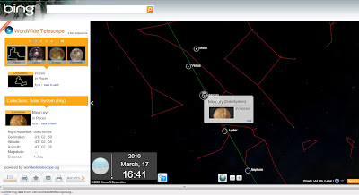
Worldwide Planets and charts
Exploring Planets is made easy from the data catalogue on the left hand side in the legend panel and click the very small "fly to" links. Zooming is very fast but not quite light speed.

View the Sky in Bing Maps
http://www.bing.com/maps/explore
Select >Maps Apps >Worldwide Telescope

For much more details and vast about of pulling tons of collections from the Worldwide Telescope Community including Constellations, Solar System, All-Sky Surveys, Spitzer Studies, Chandra Studies, Hubble Studies, Astrophotography, Radio Studies, NOAO Studies, Gemini Studies, Messier Catalog, Planets/Moons, Earth (Bing!), Panoramas, and Tours.
Then go to:
http://www.bing.com/community/blogs/maps/archive/2010/03/10/new-bing-maps-application-worldwide-telescope.aspx

Labels: , , , , , , , , ,

14 September 2007

Google Moon Update (Map & Charts)

Google Moon Update (minus the cheese)

Google Moon Updated


  • Higher Resolution Images
  • Moon 'Walk' View
  • No Cheese (was on max zoom - Wallace & Gromit ate it all?)

Data/Map Types:

Visible - A mosaic of images taken by the Clementine mission. This is a black-and-white version of what you would see if you were in orbit around the moon. This composite imagery was prepared by the USGS.
Elevation - A lunar terrain map generated by the USGS in conjunction with the The Unified Lunar Control Network 2005, and shaded using an airbrushed shaded relief map. This map is colour-coded by altitude, so you can use the colour key at the lower left to estimate elevations.
Apollo - A collection of place marks that tell the story of the Apollo missions that landed on the moon. This includes stories, quotes, images, panoramas, audio clips, and links to videos of the astronauts' adventures on the lunar surface.
Charts - A collection of geological and topographic charts of various regions of the moon.

Official Post
http://google-latlong.blogspot.com/2007/09/new-moon.html

Labels: , , , , , ,

20 November 2006

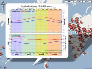
Global Climate Map and Charts

Average weather charts for 4305 global locations. Most show precipitation, many show high and low temperatures, some also have humidity.

Interactive Climate Map

When you zoom in, some more locations will show up in a few seconds.

This site is for Tourists, other travelers, students, meteorologists, climatologists, or anyone else interested in climate around the world.

Labels: , , , , , , ,