->

17 March 2010

Worldwide Telescope (WWT) now in Bing Maps

Worldwide Telescope (WWT) now in Bing Maps [Preview mode]

The Sky at night (and day) in Bing Maps Explore

With the new Bing Maps Worldwide Telescope (WWT) App you can explore the constellations and other known space objects just like you would navigate through a regular Bing Maps.Worldwide Telescope Preview in Bing Maps
To access this use the "Map Apps" and choose Worldwide Telescope

Drag Telescope Icon Preview in Bing Maps
Drag the Telescope image to a location on the map you want to view (this sets the view up as "looking up" from that point from the Earth)
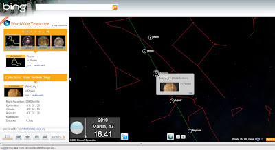
Worldwide Planets and charts
Exploring Planets is made easy from the data catalogue on the left hand side in the legend panel and click the very small "fly to" links. Zooming is very fast but not quite light speed.

View the Sky in Bing Maps
http://www.bing.com/maps/explore
Select >Maps Apps >Worldwide Telescope

For much more details and vast about of pulling tons of collections from the Worldwide Telescope Community including Constellations, Solar System, All-Sky Surveys, Spitzer Studies, Chandra Studies, Hubble Studies, Astrophotography, Radio Studies, NOAO Studies, Gemini Studies, Messier Catalog, Planets/Moons, Earth (Bing!), Panoramas, and Tours.
Then go to:
http://www.bing.com/community/blogs/maps/archive/2010/03/10/new-bing-maps-application-worldwide-telescope.aspx

Labels: , , , , , , , , ,

14 March 2008

Google Sky (Web Version) Released

Google Sky (Web Version)

Google Sky
Google have just released Google Sky (Web Version) - Works in the same way as Google Maps does, but you now look up from the Earth to view the Sky at Night.


Google Sky Web Version
Google Sky Web Version (English UK)
Date Collected from:
Digital Sky Survey
Digitized Sky Survey
Hubble Space Telescope.

"Select the thumbnail images at the bottom of the display to bring up the planets, the constellations, highlights from the Hubble Space Telescope, famous stars, galaxies and nebulae, views of the universe in the x-ray, ultraviolet and infrared"

Other items available through Google Sky:

Backyard Astronomy - Highlights the stars, galaxies and nebulae that can be seen with a pair of binoculars or a small telescope. These placemarks tell you about the celestial objects as well as providing links to sites such as Google Scholar where more detailed information can be found
Infrared - An infrared view of the sky from the Infrared Astronomical Satellite (IRAS). Change the transparency of this layer by moving the slide bar to blend the optical and infrared.

Microwave - A view of the microwave sky from NASA's Wilkinson Microwave Anisotropy Probe (WMAP), which shows the universe as it was 380,000 years after the big bang.

Historical - The sky as drawn by Giovanni Maria Cassini (printed in 1792) showing the constellations in their classical form from the collections of David Rumsey

Is the imagery different from Sky in Google Earth?
The images seen in Google Sky are identical to those found in Sky in Google Earth. Google have changed the projection to display these images within Google Maps (the Mercator projection). As with Google Maps this means that the northern and southern celestial pole cannot be shown.
Source: Google Sky Help Pages

Official Google Blog: http://googleblog.blogspot.com/2008/03/space-jam.html
Lat Long Blog: http://google-latlong.blogspot.com/2008/03/organizing-more-than-one-worlds.html

Labels: , , , ,

14 December 2007

Google Maps API - See the Sky, Moon and Mars

Google Maps API - have released Sky, Moon and Mars tiles in Version 2.95 of the API.

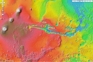
Google Maps API Mars Elevation Mode
Mars Elevation Tiles

This means you can now call up the tiles that Google Maps Moon/Mars and Google Earth Sky mode use.

Google Maps API Mars Mode
Mars there is an Infrared option too.

Google Maps API Sky Mode
It's dark out there!

Google Maps API Moon Mode
no cheese but good detail.

The original page
http://econym.googlepages.com/example_moon.htm

one bug found by Mike Williams [Google Maps API Guru]
http://econym.googlepages.com/bug_moon.htm
polylines disappears on switching modes
[this bug is already reported]

Mapperz version soon followed - as the curiosity got to them.

http://mapperz.googlepages.com/Google_SKY_MOON_MARS_Official_API.htm
l

More info:
http://groups.google.com/group/Google-Maps-API/browse_thread/thread/9da5d9f4d8dae310#

Official Blog Post
http://googlemapsapi.blogspot.com/2007/12/maps-from-another-world.html
Official Examples
http://gmaps-samples.googlecode.com/svn/trunk/planetary/planetary_maptypes.html

Labels: , , , , ,

22 August 2007

Google Sky Earth (inside Google Earth) New!

Update: As expected Ogle Earth does an excellent introduction to 'Google Earth 4.2'

One pointer that users should be aware is that it now supports KML 2.2 (beta)
http://code.google.com/apis/kml/documentation/kml_tags_beta1.html

now includes:
  • ExtendedData (replacement for metadata)
  • Atom feeds
  • AbstractView
  • ResourceMap
  • PhotoOverlay
  • Google Earth release 4.2, video is supported!
Official post on this http://google-latlong.blogspot.com/2007/08/sky-final-frontier.html

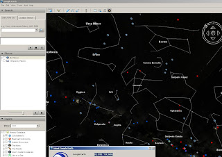
Google Sky is an addition to Google Earth New!

Google Sky Earth

You will need to download the newest version of Google Earth to use it.
version 4.2.0180.1134

http://earth.google.com/download-earth.html

More info
http://news.bbc.co.uk/1/hi/technology/6955787.stm

Works well so far - but only had 10 minutes...

Google Sky Button
The Google Sky button is here on the new version.

Labels: , , , , , ,

Satellite Finder Map - Updated

Update:
11/09/2007

Dishfinder (Global Coverage)

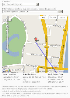
Satellite Finder Map

A nice and easy way to find Satellites to receive TV programmes.
now with Elevation, Azimuth, and LNB Skew New!

"For all DIY satellite enthusiasts and satellite installers this is a very useful and genuine "

Satellite Finder Map

Enter a valid address then the click Go!
A line and marker appear - the marker is draggable (use satellite/aerial mode to find the right location)
Sky is Default and there is a huge list of other satellites available.

Satellite List

Update 21.08.07: The elevation and LNB skew calculation results just underneath the map. These are calculated and displayed in real time as soon as you move the marker or change the satellite.

Find your satellite using the map

Mapperz

Labels: , , , ,

27 June 2007

Sky News - UK Flooding Map (Pics)

Update - if your looking for UK Floods in Southern, West and Midlands [20th July to 24th July 2007]
Go to the newer page
http://mapperz.blogspot.com/2007/07/uk-flooding-links.html


Sky News UK Flooding Map showing pictures of the Flooding in the North of England - News has Location.


Sky News UK

More and more Maps are Illustrating news events - giving the users a sense of the scale of the matter.
(other parts of the UK have been affected - though the North of England has had it very bad.)

Source: Google Maps Mania via Press Gazette

More Flooding Pictures from the BBC Site

Labels: , , , , ,