->

24 July 2008

StreetCities.com - Embed StreetView with Ease

StreetCities.com - Embed StreetView with Ease

"The Street/Map control lets users easily embed a street view into any website and switch between street view and the map."


  • Display a Street View and Map in one compact control
  • Easy to customize and embed in any webpage
  • Display the current street view title and co-ordinates
  • Supports Firefox, Internet Explorer, Safari and Opera
  • Use URL parameters to modify the control appearance
  • API and source code available under Apache License for custom projects


Street Cities - Free Mapping and Street View Tools

Need to customise this?
Then http://www.streetcities.com/StreetMapAPI.aspx is your location.
Well done to Map Channels for this easy to use site.

Labels: , , ,

04 February 2008

Track your Pizza (Map)

Track your Pizza from oven to door.
(when tracking becomes is a serious business!)

Domino's Pizza Tracker™ are permitting people to check the progress of their order to the nearest 40 seconds. By using their telephone number, customers can see the name of the person who took their order. They can see at the same time at which the pizza goes into the oven and the points at which it is removed, boxed, bagged and put onto a delivery bike\vehicle.
Pizza Tracker
Image:
http://www.dominos.uk.com/media_centre/pictures.aspx

Domino's said the initiative followed a study of the emotions involved in awaiting a pizza which revealed that the "high" at the point of ordering was followed by a trough of anxiety.

"People have told us that anxiety sets in. They don't know if we've got their order, if we'll get it right, if it will arrive on time," said spokesman Tim McIntyre. "The tracker takes out the mystery involved."
http://www.guardian.co.uk/business/2008/jan/31/fooddrinks

With the new system, after an order is placed, the customer can go to dominos.com, click on the Pizza Tracker icon and follow the progress of the order. The site confirms that the order has been received, when the pizza is in the oven, when it's been boxed and when it's left the store.
http://www.usatoday.com/money/industries/food/
2008-01-29-pizza-tracker_N.htm

Bet your hungry too, now...

Labels: , , ,

22 August 2007

Satellite Finder Map - Updated

Update:
11/09/2007

Dishfinder (Global Coverage)

Satellite Finder Map

A nice and easy way to find Satellites to receive TV programmes.
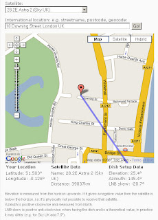
now with Elevation, Azimuth, and LNB Skew New!

"For all DIY satellite enthusiasts and satellite installers this is a very useful and genuine "

Satellite Finder Map

Enter a valid address then the click Go!
A line and marker appear - the marker is draggable (use satellite/aerial mode to find the right location)
Sky is Default and there is a huge list of other satellites available.

Satellite List

Update 21.08.07: The elevation and LNB skew calculation results just underneath the map. These are calculated and displayed in real time as soon as you move the marker or change the satellite.

Find your satellite using the map

Mapperz

Labels: , , , ,

07 August 2007

Foot and Mouth Map - Surrey

Update - a second outbreak confirmed (11am BST 07/08/07)

A Second Outbreak Foot and Mouth Map
More info on the Defra and BBC News pages

Foot and Mouth Map - Surrey (UK)


"Following an investigation of suspected vesicular disease by Animal Health on a holding near Guildford in Surrey, laboratory results on Friday evening, 3 August indicated the presence of the Foot and Mouth Disease (FMD) virus in samples from cattle on the premises."
Source: Defra

here is the map (available as a pdf here)
Defra Foot and Mouth Map - Surrey UK

What is foot and mouth? (wiki)

The interactive version is now available.
http://www.gisdiseasemap.defra.gov.uk/intmaps/FMD/map.jsp
Defra Foot and Mouth Interactive Map - Surrey

More information on the BBC News Website

Mapperz

Labels: , , ,

20 July 2007

Track Your Shoes (GPS Gadget)

GPS in your Shoes

Ever lost your shoes?

Here is a pair you can always find

GTXC GPS Shoe

"smallest lightest, most durable and powerful electronics on the market today

Interchangeable, waterproof and shock-proof module, from one shoe to the next"

http://www.gtxcorp.com/whatshot.htm

You can track your shoes and view the trail in Google Maps and Google Earth

Using Assisted GPS (now available in the N95 phone also)
PDF on this Technology (for geeks)

But can it recharge by walking?

Which shoe has the chip either or both?

Labels: , , , ,

15 June 2007

Updating Maps, on the Fly with TomTom Map Share™

Updating Maps, on the Fly with TomTom Map Share™
A Web 2.0 Solution?

"Map Share™ is a proprietary map improvement technology unique to TomTom, which enables users to easily and instantly improve maps. TomTom users can respond in real time to changes in the road network and correct the maps on their TomTom devices accordingly. Thanks to the smart user interface, it is easy to make improvements, such as blocked or unblocked streets, reversed one way traffic or new street names, which will instantly take effect."
(The TomTom satellite navigation community has over 10 million users.)

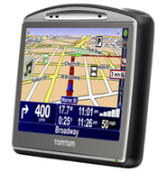
TomTom GO 720
Featured:TomTom GO 720
Image Source: TomTom

But how many will actually use the updating software?

The MapShare software will be released for older TomTom GPS units

Labels: , , , , , , ,

16 April 2007

Get A Little Extra - Tesco Maps

Get A Little Extra - Tesco Store locater maps
Easy uncomplicated store and nearest stores locater, click on icons (markers) for the opening times, address and contact numbers.
Tesco Map
"Find Tesco store locations on a Virtual Earth map of the UK with an optional satellite image overlay. Hover the mouse over a location to get directions, or click on the name of the store to view its address, phone number and store hours."

http://www.tesco.com/storelocator

includes
  • Tesco Extra (the largest stores)
  • Tesco Express (small convenience stores)
  • Tesco Metro (food only small stores)

There are more out there than you think!

Uses Microsoft Virtual Earth,Live Local, Live Maps (enter another name here in two days).

"It's been named MSN Virtual Earth, Windows Live Local, Windows Live Maps, Live Search Maps and now Live Maps."
Official Source Virtual Spaces Blog


Mapperz

Labels: , , , , ,

05 April 2007

My Maps Service - New from Google Maps

All New from Google Maps 'My Maps' - Make your own Custom Maps with help from Google Maps

Like this....
My Maps New from Google Maps
(note mapperz not really having Tea with the PM purely for example reasons and testing this useful service out)

So how do you get this to work?
Easy if you have a Google account. If you want one you can sign up here
Login and go to http://maps.google.co.uk
or your localized area eg http://maps.google.com

Click on My Maps New
In the Left Table of Contents

You will notice some new icons appear
My Maps New Icons Edit Mode
Pan, Create Marker, Create Line, Create Polygon
Now Search for your area of interest, 10 Downing Street, London, UK in this instance
this will zoom into and place a 'found' marker to show you the centre point.

Now you can add your own marker (like mapperz has to locate Number 10)

This is easy to create and edit, you can have as many markers as you like.

Google provide a tool tips help when using the point, line and polygon in edit mode.
Drag to move vertices polygon edit mode

Want to edit the colour and transparency of the polygon?
easy

Editing polygon fill transparency
Transparency or Fill Opacity can be changed so that the background mapping can be seen.
Default is 45, (100= solid fill, 0= no fill)

Okay now you have a go!

Top Tip: If you want a KML file so you can view in Google Earth you can use the KML Icon in the Top where 'Link to Page' is located.

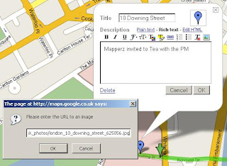
To add an image - use the 'Rich Text' Mode
Add images to my maps rich text mode
Click on the image icon on the toolbar and find a copyright free image or your own which is hosted on a webserver/site.Copy Image Location on the image and paste into the prompt on the My Map Editor as above.

The same can be done with Video from the likes of You Tube, MySpace etc.

For a more interactive tutorial (video) please visit the following (after the ad)
http://news.com.com/1606-2_3-6173473.html?tag=ne.vid

Want more information on this?

Google Earth Blog does a good round-up of this new service...

"The really interesting aspect to the announcement is that the underlying data is all KML! KML is the file format for Google Earth content - and now Maps too. This means you can create your maps and then click on the "KML" in the upper right of the map and immediately view the content in Google Earth. Furthermore, when you search for content you will not only be able to get local business search results, but also get KML search results (just like the recent KML search update for Google Earth). Look for a "See user-created content" link after the other results - it only appears when there is relevant content searched in the current view (see example)."

Source: Google Earth Blog

more info to feed on here...

Official Post: map-making-so-easy-caveman-could-do-it
Official 'My Maps' Help: http://maps.google.com/help/maps/userguide/index.html

And of course Google Maps Mania blogged it.

mapperz

Labels: , , , ,