Mapperz - The Map & GIS News finding blog. With so many Mapping sites online. This blog tries to provide you with the best maps and services that are currently available online.
@mapperz
Left toolbar highlight large data download - red (large) amber medium and green is small data. (OSM Servers will restrict large downloads automatically)
Take OpenStreetMap and via it's API, users can download an area of interest.
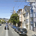
FME Workbench for converting to Google (or 3D PDF etc) Output is A clean representation of OSM in Google Earth - but with 3D Building Extruded from the data. This can also be viewed in Streetview in Google Earth.
Extruded 3D Building (from Open Street Map) overlaid in Streetview in Google Earth.
This does use FME Desktop (a 30 day trail is available) which can convert the OSM files into Google Earth
Try BBOX.ME (created and founded by Peter Segersted and Ulf Mansson) http://bbox.me/osm/
Google Earth lets you fly anywhere on Earth to view satellite imagery, maps, terrain, 3D buildings, the ocean and even galaxies in outer space. Explore rich geographical content, save your toured places and share with others. Download the latest version free of charge.
The Google Earth KML shows how the world would be affected by a global average temperature increase of 4 Degrees Celsius is an awareness in climate science.
Using Google Earth this illustrates rising levels of sea water and reduction in crop yields in different parts of the globe if temperatures are not stemmed by reducing greenhouse gases.
On 14th July, the FCO and DECC launched an interactive map showing some of the possible impacts of a global temperature rise of 4 degrees Celsius above pre-industrial times. It underlines why the UK Government and other countries believe we must keep global warming to 2 degrees Celsius. The map includes videos from the contributing scientists, led by the Met Office Hadley Centre, talking about their research. It also includes examples of what the FCO and British Council are doing to build understanding globally of the urgent need for all countries to accelerate the transition to a low carbon economy.
Government chief scientist Professor John Beddington said there was "no doubt there is a problem in public confidence in climate change".
Between November last year and February this year, the number of people who thought climate change was not happening had increased and the number who thought it was man-made had fallen.
The map, which will be updated as new data becomes available, features videos of scientists talking about the research behind the potential impacts of climate change and information about work undertaken by the Foreign Office and British Council.
Climate change minister Greg Barker said politicians had a responsibility to help make it easy for people to take action on climate changes.
And he said: "A lot of this is about the tone - there was a slight sense the climate community, and politicians are a large part of that, got what was coming to it.
"It was being a little too preachy, had a little bit of a high moral tone."
He said people did not need to deal in absolutes to make a strong case for action on climate change and it was in the UK's long-term interest to lead the way on the move to a low carbon economy.
Ed Parsons from Google said: "This is a great example of the benefits of using the latest web technology to visualise scientific information and promote better understanding of the potential impacts of climate change."
04/02/2009 17.20 update: Apologies if your getting this message "The bandwidth or page view limit for this site has been exceeded and the page cannot be viewed at this time. Once the site is below the limit, it will once again begin serving as normal. " This has been more popular than expected @mapperz will find a backup host asap. 04/02/200918.10 FIXED!!! see below for Alternative site.
Attributes of the bedrock can be obtained my click on the coloured polygons
The data has been available from the British Geological Survey (BGS) Website in KMZ (Google Earth) Format, but in this case there is no need to download as have overlayed the kmz files on Google Maps.
*Some users will find the maps slow to load, google does cache kml/kmz files.
For DiGMapGB and related purposes all these rocks are placed in a separate Bedrock theme of information. Wherever possible, they are referred to by their current name; for stratified units this will usually be of lithostratigraphic type. More information on units is available in the BGS Lexicon of Named Rock Units.
These DiGMapGB-625 data can be used free of charge for personal, teaching, academic and non-commercial purposes. DiGMapGB data are available in many scales and formats, and for commercial use purposes are supplied under licence on request.
BGS encourages the use of its data for commercial purposes. You may download these DiGMapGB-625 data free of charge to innovate, for mashups, or to develop commercial applications. However, the data remain the property of BGS (NERC). Before launching any commercial services using these data you must therefore either
* arrange a licence permit (contact ipr@bgs.ac.uk), or * contact using BGSdata@bgs.ac.uk to discuss a collaborative commercial agreement.
Prefer to use Google Earth? Follow the link below to save the KML files to your PC or choose to open it with Google Earth. Bedrock data is currently made available. http://www.bgs.ac.uk/data/services/digmapgb625kml.html
Note on the data: Bedrock geology (formerly known as 'solid' geology by BGS) is a term used for the main mass of rocks forming the Earth and present everywhere, whether exposed at the surface in outcrops or concealed beneath superficial deposits or water. The bedrock has formed over vast lengths of geological time ranging from ancient and highly altered rocks of the Proterozoic, some 2500 million years ago, or older, up to the relatively young Pliocene, 1.8 million years ago.
Contributors will be able to help creat buildings for over 50 cities. (likely to expand in the future)
"We [Google] like to think of Building Maker as a cross between Google Maps and a gigantic bin of building blocks. Basically, you pick a building and construct a model of it using aerial photos and simple 3D shapes – both of which we provide. When you're done, we take a look at your model. If it looks right, and if a better model doesn't already exist, we add it to the 3D Buildings layer in Google Earth. You can make a whole building in a few minutes."
The YouTube Video shows how fast it is to add/contribute your own buildings, Google will check them and when verified they will acknowledge your work. Building Maker in Cardiff - with simple tools to create buildings
Requirements before you can contribute:
Building Maker is an online tool, and it runs entirely in your web browser (Google Chrome, Firefox, Safari, Internet Explorer, etc.)
Before you can add a building to Google Earth, you need to sign in to your Google Account(so you get credit for what you contribute).
Models you create with Building Maker "live" in the Google 3D Warehouse (a giant, online repository of 3D models).
You can use Google SketchUp (the free, general-purpose 3D modeling tool) to edit or otherwise modify anything you make with Building Maker.
Make sure you have the latest version of Google Earth installed on your computer.
"The site is intended to offer information about this area, in addition to providing maps, views and virtual tours of its villages, lakes and mountains. These are intended to enhance your appreciation and enjoyment of the Lake District."
The site also uses Google Earth to overlay walking routes in addition to information of mountain features on many of the Lake Districts Fell.
"This site uses the Google Earth Plug-in on a number of pages. This innovative software presents us with a fresh way of viewing the Lake District from a range of new perspectives. You can view 3d image models of the mountains and valleys, and take guided tours around the villages and lakes. You are also free to visually navigate around the district going wherever you choose. I have found this a great way to get to know Lakeland in intricate detail."
Google Earth 5 - Real-time buoys data provides current conditions the ocean.
"If you've ever wondered how your neighborhood has changed throughout time, Google Earth now gives you access to the past. With a simple click, check out suburban sprawl, melting ice caps, coastal erosion, and more."
New toolbar gives easier access to control features
Dive beneath the surface of the ocean
In the new ocean layer, you can plunge all the way to the floor of the sea, view exclusive content from partners like BBC and National Geographic, and explore 3D shipwrecks like the Titanic.
Dive beneath the surface and visit the deepest part of the ocean, the Mariana Trench
Explore the ocean with top marine experts, including National Geographic
Learn about ocean observations, climate change, and endangered species
Discover new places including surf, dive, and travel hotspots and shipwrecks
Track and share your paths with others
Take placemarks a step further and record a free-form tour in Google Earth. Simply turn on the touring feature, press record, and see the world. You can even add a soundtrack or narration to personalize the journey.
Bathymetry has now been made available in Google Earth - Looks good from along way out but when you zoom in it becomes a little less useful.
But when the terrain [3D] option is switched on it doesn't reflect the true depth of the oceans, a little disappointing. Maybe a future enhancement...
Now there are a few good blogs more involved with Google Earth [Users and Developers]
Here are their thoughts - for more detailed information and comments visit the blog sites. "Hopefully they can vastly improve the edge matching, aka the coastline, then I wont mind." Barry Hunter Nearby Blog 18/01/2009/01
"But what this layer also hints at is that the mooted and hoped-for true 3D ocean landscape is likely not arriving anytime soon to Google Earth. A true bathymetry DEM for the globe would have been a real feat, but instead we'll be looking at a 2D rendering of it for a while yet." Stefan Green Ogle Earth 20/01/2009
"some island atolls which had low resolution data look less "visible" in the new imagery. Particularly noticeable are the Maldives, also St. Helens, Montagu Island, and many other islands now show "floor" instead of the islands" Frank Taylor - Google Earth Blog 17/01/2009
If you don't have Google Earth [available for Mac & PC] you can download it for free from http://earth.google.com/
It's been a little while since the last update to the software, so expect a new version in the near future. Mapperz
Google Earth Plug-in, version 4.3.11498.3261 (Windows, Mac) 12/03/2008
* Launch of the Google Earth Browser Plug-in for Mac OS X * Startup time on Windows has been improved. * KML/KMZ parsing and rendering speed has been improved. * XML Namespaces are now supported during KML parsing. * (Issue 66) Polygons and line strings are now interactive and mouse events on these geometries can now be listened to using google.earth.addEventListener. * (Issue 76) Fixed a bug that caused a 'Could not create folder' error message upon plugin instantiation if there were spaces in the logged in user's username. * (Issue 59) Fixed a bug that caused placemarks in interval-refresh Network Links to be duplicated upon user interaction.
A recent update which includes the option of 'Earth' (Google Earth inside the web browser)
Allows the user to create a route of their choice and view it in 3D - attribution of the points is available. Export to GPX for input into a GPS device. *Earth plugin must be installed to view the content. In the drop down list select OS+Earth
There is a limit on the number of Ordnance Survey tiles per a 24 hour period (30,000 tiles) - keep an eye on the percentage bar in the bottom left corner. OS please raise this limit to 50k or higher. http://wheresthepath.googlepages.com/wheresthepath.htm Full credit goes to Bill Chadwick for producing this nifty side-by-side mapping application.
Updated 29th May 2008 - With Examples (3D Plugin Required)
A few minutes ago after this updated post- Mapperz has an email from Rob at Map Channels with this updated See Bournemouth Map with the 3D Google Earth Maps. The New Google 3D Maps Live and Working on http://www.seebournemouth.com/GoogleMap.aspx
Well Done Rob and full credit for integrating this so quickly - more like this please.
Click the Earth [Map Type] option next to Terrain
Google Earth API Arrives! (The Web Browser Version) WOW!
Another prediction from Last Year has finally made it. This a image is not from Google Earth Desktop but Firefox.
Google Earth 4.3 (Beta) is now available to download
Google earth 4.3 has new features...
3D buildings look more true 3D and real. (Can now view in daylight/shadows/nighttime)
StreetView in Google Earth (See the 'Layers' >StreetView) Click on the curved photographs zooms into a 'StreetView' Mode (Like in Google Maps) See the Video for more details...
New navigational controls - New features enabling better ways to look around at 3D buildings - takes few seconds to get use to the new navigation but works well.
Google Earth navigation controls offer the same type of navigation action that you can achieve with mouse navigation. In addition, you can use the controls to zoom and swoop (perhaps for a perspective on terrain) or to rotate your view. The following diagram shows the controls and explains their functions.
Click the north up button to reset the view so that north is at the top of the screen. Click and drag the ring to rotate your view. Use the Look joystick to look around from a single vantage point, as if you were turning your head. Click an arrow to look in that direction or continue to press down on the mouse button and drag to change your view. Use the Move joystick to move your position from one place to another. Click an arrow to move in that direction or continue to press down on the mouse button and drag to move. Use the zoom slider to zoom in or out (+ to zoom in, - to zoom out). Double-click the icons at the end of the slider to reset the zoom all the way in or out. As you move closer to the ground, Google Earth swoops (tilts) to change your viewing angle to be parallel to the Earth's surface. You can also use the keyboard to control navigation. See 3D Viewer Navigation in Keyboard Controls for more information.
Imagery Dates - You will now be able to easily see the dates when imagery was taken for most imagery (but, not all).
More 3D buildings, faster loading - Faster loading the 3D building models.
New photo-textured cities.
Day/Night Lighting - Real-time sunlight lighting option. Daylight/Time slider control of the sun's shadow position across the globe.
update: 38 second clip on You Tube by request - video capture by SnagIT
OpenSpace Tiles in Google Earth
"Gavin Brock has produced an Ordnance Survey Overlay for Google Earth which enables you to view public footpaths in Google Earth. Unfortunately the kml of the overlay doesn’t appear to work when loaded into Google Maps." Google Maps Mania
Not sure on the legal aspects (OS Copyright) on this but it is impressive to see 1:50,000 Landranger Series in 3D. Some footpaths are available but 1:25,000 (Explorer Series) is the official scale for public footpaths and rights of way, currently 1:25,000 is not available in the Openspace API.
"The Placemark balloons include information about airlines and destinations. Labels follow Wikipedia’s convention of using place names rather than real airport names. Routes are displayed with exaggerated altitude. "
Guidelines: "One downside of Google Earth’s highlight mode is it doesn’t stay switched on a after a mouse click. However, there are a few navigation tricks that allow you to keep routes displayed and move around."
Click the middle mouse button on an airport icon, and hold it down while moving the the mouse.
Hover the mouse pointer over an icon, then switch to keyboard control (cursor keys, shift + cursor keys, Page up/down, + key, - key, etc…).
Click on an airport icon, quickly drag it and let go. Just as you would to set the Earth rotating.
Data source: "The source data for all this is scraped from the Airport pages on Wikipedia, and compiled using a lot of Perl scripting to scrape, mash and meld it into KML. Obviously its never going to be 100% reliable, but at least it should be pretty easy to keep the file regularly updated, and expand to other parts of the world."
Great News to users of Google Earth but the restriction is limited to Internal Use only.
Google End Users Licence Agreement (EULA)
Version 4.1"You may not use the Software or the geographical information made available for display using the Software, or any prints or screen outputs generated with the Software in any commercial or business environment or for any commercial or business purposes for yourself or any third parties."
Version 4.2 "For a business entity user, the Software may be used by you and your employees for internal use"
"Google Earth Free finally becomes a proper universal browser of georeferenced data." Ogle Earth Mapperz see's this as a great way and potential improve Google Earth and make it into a Simple GIS.
What's the difference between Google Earth, Google Plus and Google Pro?
"Google Earth" is the free product for Windows (Vista, XP, 2000), Mac (OS X 10.4), and Linux
"Google Earth Plus" is the subscription-based consumer product, available for Windows and Mac only. You can upgrade to Google Earth Plus via the "Help" menu of the free version of Google Earth. This version is for non-commercial use only. It has all the functionality of the Free version and adds the following features: * GPS devices, including real-time tracking with NMEA * Higher resolution printing * Path Measure Tool * Importation of .csv address files (limited to 100 points) * Faster network performance
- "Google Earth Pro" is for professional use. It is available for Windows and Mac and includes all the features in Plus and adds the following features: * Polygon and circle measure tools * Style templates (improve presentation of your data) * Importation of .csv address files (limited to 2500 points) * Data Importer * Movie Making * Very high resolution printing * Email and chat support
The amazing Flash Earth is a great application on itself.
Now combined it with the Desktop Google Earth (4.2)
and it becomes a very useful and powerful resource for users to compare areas where imagery and digital coverage is 'blurred'.
Layers available in Flash Earth are
Google Maps
Microsoft Virtual Earth (VE) Aerial
Microsoft Virtual Earth (VE) Labels
Yahoo Maps
Ask Maps
Ask Aerial
Open Layers
NASA Terra (Daily)
*NASA shows the smoke from the fires that have swept across Greece (BBC News Link)
Even Google Earth Rotation is maintained when the Flash Earth is activated inside Google Earth.
"What if the current view in Google Earth was quickly viewable in other maps, such as those made accessible by FlashEarth? Well, now it is. As you move around the globe a little white arrow follows you around, simple click it to get an approximation of the current view in FlashEarth in a popup balloon."
Total credit to Valery35, for the concept (including a screenshot) on the Google Earth Community and to all the people made all the bits that could be pieced together in this 15min hack.
Currently Category 4 "Winds 131-155 mph (114-135 kt or 210-249 km/hr). Storm surge generally 13-18 ft above normal. More extensive curtain wall failures with some complete roof structure failures on small residences. Shrubs, trees, and all signs are blown down." There is potential for this hurricane to be upgraded to category 5...eek! " Dean is now over very warm water and in an ideal situation to strengthen further." Rob McElwee, BBC Weather
Hurricane Dean - Mapped and Tracked
View live updated content for Hurricane Dean with predicted courses based on category (currently 4).
The KMZ for Google earth comes with more information.
 via FME")


 overlaid in Streetview in Google Earth")


")


