->

23 July 2009

Google Maps Mobile (3.2) More Layers

Google Map Mobile (3.2) More Layers

Google Maps Mobile - More Layers
New Layers come to Google Maps for Mobile Devices

The new version, 3.2.0, adds a 'Layers' of information displayed on top of the map background to assist users to find out features and real-time incidents and transit information.

Google have updated Google Maps Mobile and there are new features such as:
  • Wikipedia Layer
  • Transit Layer - with real-time data
  • MyMaps Layer - add your own content from MyMaps.
  • Nearest features - search around your current map location.

Google Maps Mobile - Transit Layer
Layers make it easier and more useful to find and interact with geographic content, like public transit, traffic (with incidents!), local search results, Latitude friend locations, Wikipedia and more. You can also see your own My Maps content as a layer on Google Maps for mobile. And finally, multiple layers can be combined at the same time to give you a content-rich view of what's around you.

Google Maps Mobile - Wikipedia and Nearest Features

Updated Release Notes:
http://www.google.com/support/mobile/bin/answer.py?answer=156059

Related Post:
A nice roundup of the features are available from AllAboutSymbian
http://www.allaboutsymbian.com/news/item/10160_Layers_added
_to_Google_Maps_fo.php

Official Source:
http://googlemobile.blogspot.com/2009/07/layers-of-fun-in
-google-maps-for-mobile.html

Labels: , , , ,

02 February 2009

Google Earth 5 (Beta) More New Layers

Google Earth 5 (Beta) More New Layers

KML Update:
The KML documentation has now been updated for users wanting to create tours underwater.
http://code.google.com/apis/kml/documentation/kmlreference.html#kmlextensions

Official Posts
http://google-latlong.blogspot.com/2009/02/new-in-google-earth-50-historical.html

http://google-latlong.blogspot.com/2009/02/deep-dive-into-ocean-in-google-earth.html

http://googlegeodevelopers.blogspot.com/2009/02/ocean-time-machine-and-touring-new-kml.html

Google Earth 5 New Layers
Google Earth 5 - Real-time buoys data provides current conditions the ocean.

"If you've ever wondered how your neighborhood has changed throughout time, Google Earth now gives you access to the past. With a simple click, check out suburban sprawl, melting ice caps, coastal erosion, and more."

Google Earth 5 New Layers

New toolbar gives easier access to control features
Dive beneath the surface of the ocean

In the new ocean layer, you can plunge all the way to the floor of the sea, view exclusive content from partners like BBC and National Geographic, and explore 3D shipwrecks like the Titanic.

  • Dive beneath the surface and visit the deepest part of the ocean, the Mariana Trench
  • Explore the ocean with top marine experts, including National Geographic
  • Learn about ocean observations, climate change, and endangered species
  • Discover new places including surf, dive, and travel hotspots and shipwrecks
Track and share your paths with others

Take placemarks a step further and record a free-form tour in Google Earth. Simply turn on the touring feature, press record, and see the world. You can even add a soundtrack or narration to personalize the journey.

Please Visit the Excellent http://www.gearthblog.com

for more detailed and in depth information on the newest release of Google Earth.

Historical Imagery
New Google Mars
New Google Ocean

To Download Google Earth 5 go:
http://earth.google.com/ocean/
**High Speed Broadband recommended if using this free product.

Labels: , , , , ,

13 May 2008

Google Maps adds 'More' and Explore

Google Maps adds 'More' and Explore

Google Maps has added Wikipedia and Photos from http://www.panoramio.com/

Google Maps More and Explore
This enhances the online mapping application into a more powerful and visual locating tool.
Google Maps More and Explore Location
Clicking the 'More' exposes the new available layers.

See it in action

These features seem to be spawned from the Google Earth Desktop application and now made available in the web browser.

So when will Google Maps do 3D?

Source and more information available at Google Maps Mania

Labels: , , , ,

05 December 2007

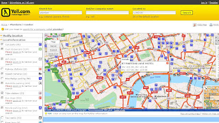
Yell Maps - New Features

Yell Maps - New Features

Yell Maps - New Features

MultiMap Based Mapping
Microsoft Virtual Earth Birds Eye View Mode
Points of Interest (POI)
  • Car parks
  • Cash dispensers
  • WiFi Access
  • Railway stations
  • Speed Cameras
  • Blue Badge parking
  • Motorbike parking
  • Public toilets
  • Tube stations
  • Bus stops (Includes Bus Routes for that location)
  • Traffic news
  • Bicycle parking
  • Taxi ranks
  • River taxis
Note: POI Features are available in the Birds Eye View - Helps visually to users and builds a mental picture for when they get there.

Yell New Maps Birdseye with POI Overlayed

Yell New Maps Birdseye POI East Oblique View

Where to find these maps
http://www.yell.com/ucs/HomePageAction.do
and search with the 'Show on Map' ticked.

Think this is the first type of cross Mapping as using Multimap for the base mapping - but then Microsoft Virtual Earth is being used in the Birds Eye View.

Yell have done a good update and this will be the best mapping they have had on there website.
Prediction - 2008 Hybird Mapping API. Though check Terms and Conditions on using different mapping applications together, some prohibit use with 'competitors' mapping solutions.
i.e. Yahoo Geocoder is only allowed to be used with Yahoo Maps.

Labels: , , , , , ,

26 June 2007

Environment Agency - Adds Pollution Maps

Environment Agency - Adds Pollution Maps
(as well as Flooding)

Environment Agency Pollution Maps

You can now select individual polluting gases and their location that can be define and find more information about the substances
example
Carbon Dioxide

Main Sources of Air Pollution


  • Air quality and emissions
    Find out how air quality has changed over time, and how emissions of different substances impact on the environment and health.

  • Air pollution incidents
    In 2005 154 pollution incidents had a serious impact on air quality in England and Wales, the lowest number on record.

  • Acid rain
    Acid rain has been tackled for over a decade with some success.

  • Ozone depletion
    Ozone in the upper atmosphere shields the earth from harmful ultra violet (UV) radiation emitted by the sun. Man-made chemicals have damaged this “ozone layer”, allowing more UV radiation to pass through.

Other Sources of Pollution


  • Pollution incidents - Pollution incidents such as oil spills or the accidental release of raw sewage can damage the environment, harm wildlife and pose a threat to human health.

  • Ozone depletion- Ozone in the upper atmosphere shields the earth from harmful ultra violet (UV) radiation emitted by the sun. Man-made chemicals have damaged this “ozone layer”, allowing more UV radiation to pass through.

  • Acid rain - Acid rain has been tackled for over a decade with some success

  • Noise - Noise from industry, traffic and homes can annoy, disturb sleep and affect health.

  • Light pollution - Light pollution has reduced our ability to view the night sky and causes impacts on wildlife. England is more brightly lit than other European country with the exception of the Netherlands.

  • Environmental Crime - Illegal activities can directly harm wildlife or the environment. This section covers breaches of permits and fly tipping.

  • Nutrients in rivers, lakes and coastal waters - Nutrients are essential for aquatic life, but high levels can upset ecosystems, create unsightly algal blooms and even threaten our health.

  • Fertilisers - Fertilisers must be used with care to avoid pollution.

  • Pesticides
And they still deal with flooding. But check your local area - the data and mapping for flooding is a little dated in places.

Environment Agency Flood Maps
EA vs OnOneMap Technologies
Comparing Environment Agency 'Mapping' (not data) with OnOneMap
Users prefer ease of use with OnOneMap.

Labels: , , , , ,

28 February 2007

Google Maps Live Traffic

Google Maps has now real-time traffic conditions

update:
Offical Blog: Stuck in traffic? http://googleblog.blogspot.com/2007/02/stuck-in-traffic.html

Google Maps Traffic USA Only
Google Maps Live Traffic now provides a new layer for traffic congestion
  • Green Lines equals more than 50 miles per hour
  • Orange equals 25 - 50 miles per hour
  • Red equals to less than 25 miles per hour
  • Grey equals no data available
Google Maps Live Traffic Overlay New York
3am New York (8am London GMT)
Google Maps Live Traffic Overlay New York Rush Hour
8am New York (12pm London GMT)

source: Google Operating System
mapperz

Labels: , , , ,

21 February 2007

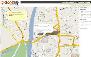
OnOneMap - Adds New Map Layers

One of the Best Customized Google Maps is OnOneMap Property Search

"We have added the ability to view the phone masts in your search area. Simply tick the phone masts tick box in the "Map options""

This is along with Schools, Supermarkets and Sold Property. There is a lot going on behind the scenes with this map, though data retrieval speed is not compromised.

OnOneMap Adds More Mapping Layers
Clicking on the mobile icons reveals the service operator for that mobile phone mast.

This is also available to enquire information about:
  • Properties in the Area for Sale
  • Schools and their success rate (in a percentage)
  • Nearby Supermarkets
All useful for decision making when purchasing a house.

Top Tip: Use the 'Nearby Anything' option - this can help find houses near a London Tube Station, Railway Station or Motorway Junction.

Excellent work OnOneMap and good to see this site evolve successfully.

Mapperz


Labels: , , , ,