->

05 February 2010

'Eye on Earth' EEA and Microsoft Bing Mapping

'Eye on Earth' EEA and Microsoft Bing Mapping

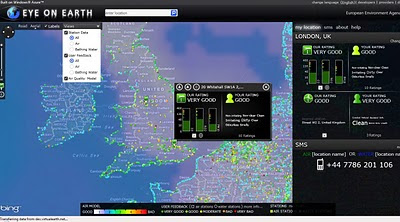
Green EU citizens are being encouraged to contribute their own environmental observations to a website.

The Eye on Earth platform is a joint venture between the European Environment Agency (EEA) and Microsoft.

Eye On Earth Bing Map

Features:

  • Air Quality
  • Air Quality Model
  • Bathing Waters

1 is Very Good (Dark Green)
5 is Very Bad (Red)

Overlaying Air Quality data from Official EEA sources and from 'user' feedback using Bing Maps.

An impressive language support exists for covering all European Languages.


View Eye on Earth - http://eyeonearth.cloudapp.net/

*The project makes use of Microsoft mapping software and Windows Azure - the "cloud"-based operating system.

Room for expansion:

"The EEA's future ambitions for the site stretch beyond water and air monitoring."

source:

http://news.bbc.co.uk/1/hi/technology/8499059.stm


Labels: , , , , , , ,

10 March 2009

"The Big Apple on the Mumbles"

"The Big Apple on the Mumbles" - Map Text (errors)
View map of Mumbles, Swansea, West Glamorgan, Wales, SA3 5 on Multimap.com
Get directions to or from Mumbles, Swansea, West Glamorgan, Wales, SA3 5
"The Big Apple on the Mumbles" is an admitted 'software' error...

"Microsoft has said a technical glitch was responsible for the unusual road name
It is a quirky landmark well know to visitors to Mumbles near Swansea. "
BBC News(Wales)

"A spokesman for Microsoft said it was a minor technical issue with its mapping software but that maps were updated regularly and it would be amended."

"The Big Apple kiosk at the entrance to Bracelet Bay has stood near Mumbles Pier for decades - selling ice cream, refreshments and buckets and spades during the summer. "

Source & More Info:BBC News

Labels: , , , ,

16 January 2009

Bird's Eye View on Windows Mobile

Bird's Eye View on Windows Mobile

Bird's Eye option Windows Mobile 6 - London
Finally Microsoft have made Birds Eye View available on a Mobile Platform - Windows Mobile 6.

Select Bird's Eye Mode
Available in the Menu and Bird's Eye Mode option
*Bird's Eye View is not available everywhere - though most large cities in the USA/Canada/Europe/Australia regions will have Birds Eye oblique aerial photographs.

Hopefully soon this will be made available to all other platforms.

Microsoft Windows Mobile 6 Users
wls.live.com

other mobile users without Microsoft Windows Mobile
m.live.com
(no birds eye view mode/content yet)

Mapperz does not have Windows Mobile 6 and likely not too but if you want to test it try the emulator:
You will need
Microsoft Active Sync
Device Emulator Manager
Windows Mobile 6 Professional SDK

Help and useful guide:
http://www.lancelhoff.com/how-to-emulate-windows-mobile-6/

Source:
http://www.livesearchmobile.com/

Labels: , , , ,

06 November 2008

Geo 3D Photosynths [Microsoft Live Maps]

Geo 3D Photosynths [Microsoft Live Maps]

Live Maps just got better -
Photosynths Pictures have now been 'GeoTagged' .
Geo Photosynth Map
The new options are available from the sidebar or on a marker on the map.


Geo Photosynth 3D Map
Available in 3D Mode - Load times vary

Requirements:
Photosynth installed - http://photosynth.net/howtosynth.aspx
3D Plug-in for Live Maps (Updated Version)

Geo Photosynth Viewer
Photosynth Viewer - linking from Live Maps.

related:
http://livelabs.com/photosynth/

Labels: , , , ,

17 October 2008

Embed Multimap Maps - New

Embed Multimap Maps - New

Multimap have announced via the Microsoft LiveSide that it is now possible to embed Multimaps in your own websites and blogs.


View map of Greater London on Multimap.com
Birds Eye view of Greater London on Multimap.com
Get directions to or from Greater London on Multimap.com

The above map is the new service of embedding multimap maps.

What is New?
  • We [Multimap] launched a new service for small businesses, personal websites and hobbyists this week.
  • The service, available for free from Multimap.com, provides a single line of HTML to cut and paste into a web page.
  • The user gets a slippy map in a choice of map styles (TeleAtlas, Ordnance Survey and Barts) or aerial for anywhere in the world (US included, using VE maps and aerial).
  • The pasted HTML includes four hyperlinks back to Multimap.com:
    1. See this location on Multimap (for a bigger map, POI, business listings, etc)
    2. See this location in Birds Eye
    3. Get directions to this location
    4. Get directions from this location
  • The service is limited to 50,000 transactions per year (which we track) and cannot be used for internal apps (eg BI, CRM)
1. 50,000 transactions a year is not very many, would be better if this was a week or a day.
2. 4 hyperlinks seems to be overkill... 1 or 2 would look better.


Can you embed Multimaps maps? Yes but Multimaps FAQ has yet to be updated.

"No. Licensing restrictions imposed by our data suppliers mean that users are not permitted to display the maps within their own website - even if the user is linking to our website behind the image. However, maps without our advertising or branding are available for a fee. Please see our Business Services section for more information on our mapping options."
http://www.multimap.com/help/#aq64

Source:
http://www.liveside.net/main/archive/2008/10/16/virtual-earth-get-a-multimap-map-on-your-site-for-free.aspx

Don't want to embed the Multimap have a tiny url creator - for the map above
http://www.multimap.com/s/Ap27JczF

Labels: , , , , , ,

18 September 2008

Live Maps - New Map Tiles

Live Maps - New Map Tiles

New Tiles
New Map Tiles
(odd with duplicate motorway junction numbers?)

Old Map Tiles
Old Map Tiles
To get the old tiles - press the 3D option - Virtual Earth plug in required.


From the Virtual Earth Blog

"now live and contains the following 46TB of imagery and vector updates."

* Vector overlays for Navteq and MDS data sources for orthos and Bird's Eye
* All mobile tiles
* New British Isles Map style

for those interested the new map tiles are load balanced from
r0.ortho.tiles.virtualearth.net
r1.ortho.tiles.virtualearth.net
r2.ortho.tiles.virtualearth.net


View some new tiles
http://tinyurl.com/4u2jrv

Labels: , , , ,

23 March 2008

SQL Server 2008 and Virtual Earth (WebGIS)

SQL Server 2008 and Virtual Earth - Looks to become a powerful online GIS (WebGIS)

Most Mapping Applications take data from a database, here users input (Points,Polylines & Polygons) and gets stored in a spatial database, After data is stored, the data can be used in simple analysis, buffering, interesecting, clipping etc. No need to have a desktop GIS anymore (?)

SQL Server 2008 as backend to WebGIS


"In the previous parts we have first been looking on the database side and how we can use various mechanisms to load and extract data and we even implemented a geocoder in the database. Then we moved on and investigated various ways to retrieve data from SQL Server 2008 and visualize them in Virtual Earth. In this final part we will now focus on using Virtual Earth as a simple data editor which allows us to write data back to SQL Server 2008."


14 tutorials using Microsoft SQL Server 2008 and Vitrual Earth


http://blogs.msdn.com/publicsector/archive/2008/03/22/virtual-earth-drawing-on-the-map-and-storing-the-result-in-sql-server-2008.aspx


Inserting a Polygon into SQL Server 2008
A polygon created and inserted into sql server 2008 on the fly.

Labels: , , , , ,

29 February 2008

Worldwide Telescope Video (Microsoft)

Worldwide Telescope Video (Microsoft)


source:
http://www.ted.com/talks/view/id/224

Labels: , , ,

12 December 2007

Microsoft Windows Update Kills ArcGIS Help

Microsoft Windows Update Kills ArcGIS Help

"ESRI® announces the ArcGIS 9.2 Desktop Help Search Patch. This patch solves an issue where the search tab in ArcGIS Desktop help becomes inoperable. We recommend all ArcGIS Desktop 9.2 users download and install this patch at their earliest convenience to ensure the highest quality experience when working with ArcGIS Desktop 9.2"

BBC 's Little Britain - Computer Says No!

    NIM013534 - AnswerWorks search in ArcGIS Desktop Help will stop functioning after a Microsoft Windows Update.

    Description

    The ArcGIS Desktop help uses a 3rd party search engine called AnswerWorks. Microsoft has released a security update to Internet Explorer affecting the Desktop help search to become inoperable. This patch resolves the issue of the search engine being non functional by updating the 3rd party search engine.


NOTE:
ArcGIS Desktop 9.2 Service Pack 4 must be installed before you can install this Patch.
If you have installed client setups from a shared Network Administrative ArcGIS Desktop setup, this Patch must be applied to all client installations.

Download the Patch
http://support.esri.com/index.cfm?fa=downloads.patchesServicePacks.viewPatch&PID=43&MetaID=1357

Labels: , , , , ,

05 December 2007

Yell Maps - New Features

Yell Maps - New Features

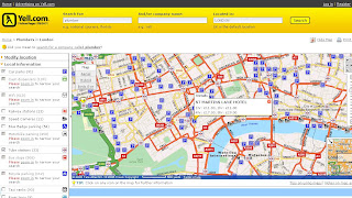
Yell Maps - New Features

MultiMap Based Mapping
Microsoft Virtual Earth Birds Eye View Mode
Points of Interest (POI)
  • Car parks
  • Cash dispensers
  • WiFi Access
  • Railway stations
  • Speed Cameras
  • Blue Badge parking
  • Motorbike parking
  • Public toilets
  • Tube stations
  • Bus stops (Includes Bus Routes for that location)
  • Traffic news
  • Bicycle parking
  • Taxi ranks
  • River taxis
Note: POI Features are available in the Birds Eye View - Helps visually to users and builds a mental picture for when they get there.

Yell New Maps Birdseye with POI Overlayed

Yell New Maps Birdseye POI East Oblique View

Where to find these maps
http://www.yell.com/ucs/HomePageAction.do
and search with the 'Show on Map' ticked.

Think this is the first type of cross Mapping as using Multimap for the base mapping - but then Microsoft Virtual Earth is being used in the Birds Eye View.

Yell have done a good update and this will be the best mapping they have had on there website.
Prediction - 2008 Hybird Mapping API. Though check Terms and Conditions on using different mapping applications together, some prohibit use with 'competitors' mapping solutions.
i.e. Yahoo Geocoder is only allowed to be used with Yahoo Maps.

Labels: , , , , , ,

19 November 2007

ESRI ArcGIS 9.2 - Tips and Tricks (Updated)

updated 16/11/2007
So ArcGIS 9.2 and with Service Pack 4 installed.
and still going slow?

Here is Mapperz ArcGIS Tips and Tricks to get you more productive without the caffeine.

Okay Please note not supported by Mapperz but these methods 'help' ArcGIS run faster and give extra memory allocation.

You will have to log on your system as an administrator to make these tweaks

Before ArcGIS the Operating System should be tuned for ArcGIS.

Based on Windows XP Pro Starting Point

Make XP Run for ARCGIS better

RAM, Virtual Memory, Pagefile and all that stuff
http://support.microsoft.com/kb/555223

How to set performance options in Windows XP
http://support.microsoft.com/kb/308417/

Edit the Boot.ini My Computer>Properties>Advanced>Start Up and Recovery>Edit (Boot.ini)

/MAXRAM

If using an AMD Processor switch off 'Data Execution Protection'
* A common problem this is left on and some ArcGIS code is detected as 'bad' code therefore arcgis install will roll back
and unistall.

NOEXECUTE=ALWAYSOFF


http://www.microsoft.com/technet/sysinternals/
information/bootini.mspx

How to configure SQL Server to use more than 2 GB of physical memory
http://support.microsoft.com/kb/274750
SQL Server 2GB

Increases the size of the user process address space from 2 GB to 3 GB
(and therefore reduces the size of system space from 2 GB to 1 GB).
Giving virtual-memory
intensive applications such as database servers a larger address space can improve their performance

/3GB

so boot.ini looks like this

[boot loader]
timeout=30
default=multi(0)disk(0)rdisk(0)partition(2)\WINDOWS
[operating systems]
multi(0)disk(0)rdisk(0)partition(2)\WINDOWS="Microsoft Windows XP Professional" /noexecute=AlwaysOff /MAXMEM /3GB /fastdetect

Now install ArcGIS 9.2 with the service pack 4
(you can make these changes after you have installed ArcGIS)

Got Floating licenses?
If so and you want to share Arc/Info licenses but allow the user to use ArcGIS you can add ArcView single license to the Desktop Administrator.

It is very simple to do this. Just add the ArcView DVD to the DVD and got to install it. It will detect that ArcInfo is already installed and adds a component into desktop administrator.
Arc Desktop 9.2 Administrator

ArcGIS Improvements

C:\arcgis\Utilities\AdvancedArcMapSettings.exe
Change
Jet Engine to 120000 from the default 9600
This allows more records to be written from memory to shapefile/geodatabase


Printing Large Plots? (over 40 inches)
http://support.esri.com/index.cfm?fa=knowledgebase.
techarticles.articleShow&d=30516

Resizing from 42 inches to 60 inches
arcview\arcpress\etc directory
arcexe9x\etc\device1.dat file
To make the RTL drivers print wider than 36":
in the four lines beginning with 'RTL', change '10350' to '12150' to print 42" wide
'14550' to print 50" wide
and '17550' to print 60" wide

Finally got a PC with or over 2GB of RAM?
make the page file size bigger

Using RegEdit (Only do this if you know what it is)

HKEY_LOCAL_MACHINE\System\CurrentControlSet\Control\
SessionManager\MemoryManagement

c:\pagefile1\pagefile.sys 3000 4000
c:\pagefile2\pagefile.sys 3000 4000
c:\pagefile3\Pagefile.sys 3000 4000

Source:
Overcoming the 4,095 MB paging file size limit in Windows
http://support.microsoft.com/kb/237740


and a last tip is those pesky *.aux files that ArcGIS creates for raster display - delete them by a dos batch file and apply it to your start up (aux_delete.bat)

ECHO OFF
ECHO .
ECHO .
ECHO .
ECHO ***************************************
ECHO * *
ECHO * DELETING TEMPORARY AUX FILES... *
ECHO * *
ECHO ***************************************
ECHO .
ECHO .
ECHO ON
cd c:\data
cd d:\data
del *.aux /s
exit

*change c:\data & cd d:\data to your own raster locations

that should make ArcGIS go a little faster.

This post is a result of user experience and Microsoft Pages and ESRI Support.
Use at your own risk.

Use the ESRI Web Based Help - this is more up-to-date than the Installed version.

Labels: , , , , , , ,

17 October 2007

Microsoft Virtual Earth Version 6 - Released

Microsoft Virtual Earth Version 6 - Released

What is it?
"Virtual Earth provides the power behind Live Search Maps, an online mapping service that enables users to search, discover, explore, plan, and share information about specific locations. By using traditional road maps, labeled aerial photo views, low-angle high-resolution aerial photos, and proximity searching capabilities, Virtual Earth provides unique opportunities for developers to incorporate both location and local search features into their Web applications."


(Finally the video uploads! - from Space to the Grand Canyon)
This is a Powerful 3D Engine - You can use it like 'Google Earth' but this is in a web browser (Firefox here with the 3D plugin already installed)

Whats is New? (lots)

Version 6.0 of the map control includes improvements in the following areas:
  • Enhanced accuracy
  • Additional functionality
  • Enhanced performance (it is a lot smoother
  • Enhanced Geocoding. Integrates multiple geocoders and datasets.
  • Rooftop Geocoding. Rooftop locations are the most precise geocoding.
  • Consistent Pushpin Accuracy. When switching between aerial and Birdseye views.
  • Multi-point Routing. A new method takes multiple points for a route
  • Switching from Miles/Kilometers available
  • Bulk Addition of Shapes. A new method to add multiple pushpins in one call.
  • Improved Shape Control. You can now specify how a shape object appears relative to other shapes or tile objects, providing greater control in viewing data and objects.
  • MapCruncher (Beta). MapCruncher Beta for Microsoft Virtual Earth makes it easy to publish maps overlaid in an application using the Virtual Earth map control. See the MapCruncher Web page for further information.
  • 3D Altitude Settings. Altitudes for three-dimensional objects can now be specified in meters.

There have been significant speed and accuracy improvements for pushpins and shapes in high numbers. Performance enhancements also include faster map panning.


MapCruncher Beta for Microsoft Virtual Earth makes it easy to publish maps overlaid in an application using the Virtual Earth map control. Once you are familiar with the tool, it will take you about ten minutes to generate a new tile layer. Just find 5 to 10 corresponding landmarks on your map and on the Virtual Earth map view, and MapCruncher will register your map to the global coordinate system, warp it to fit a Mercator projection, and generate a set of image tiles that can be seamlessly layered on top of Virtual Earth map control's standard road, hybrid, or aerial imagery. It even makes a sample HTML page for reference. MapCruncher accepts a variety of vector formats (PDF, WMF, EMF) and raster formats (JPG, PNG, TIFF, GIF, BMP). Where to get more information?
Start here http://dev.live.com/virtualearth/sdk/ test the functions out.
http://blogs.msdn.com/virtualearth/


Download the SDK Version from http://msdn2.microsoft.com/en-us/library/bb429619.aspx

More Blogs detailing the features
http://blogs.msdn.com/keithkin/archive/2007/10/17/virtual-earth-v6
-api-now-available.aspx

upgrading from version 5?
http://www.nateirwin.net/VirtualEarthMapControlV6Released.aspx


Labels: , , , , ,

16 October 2007

New Live Maps - Goes Live +KML Overlay

New Live 'Search' Maps - Goes Live

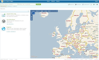
New Live Maps
New cleaner version of Live Search Maps

and the 3D gets smoother....

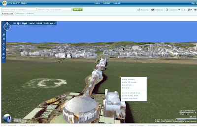
New Live Maps Brighton in 3D
Brighton Pier in 3D in FireFox.

Look for the Loader
3D Loading Rendering Progress
The Globe show the data loading/rendering for the view.

quick guide -

Shortcut keys...
Home [Button] - Birds Eye -straight down
Page up [Button] - Zooms Out
Page Down [Button] - Zooms in
Cursor keys - Pan in keys direction
Shift - Pivot on that location
Control (Ctrl) Key - tilts and rotates (with mouse)
B - Birds Eye View

Click 'N' (North) on the controls resets the direction to North.

Control and Shift keys can be use with the mouse.

Have a Play - http://maps.live.com/


Some more details coming out.

Codenamed Gemini is Version 2 of Live Maps based on the Virtual Earth 6 Engine

New Features include KML overlay (a global accepted spatial dataset now?)

Seems only points are supported so far here is an example

Google Maps KML overlay

Now Live Maps KML Overlay

Same KML URL but the route(polyline) is missing - though does allow you to subscribe to the KML via RSS

Much more information in more detail is available from the official blog
http://virtualearth.spaces.live.com/default.aspx?wa=wsignin1.0

Google Earth Blog has a very good articial on Basic KML supported by Microsoft
http://www.gearthblog.com/blog/archives/2007/10/microsoft_virtual
_earth_supports_ba.html


Mapperz

Labels: , , , , , , ,

14 October 2007

Massive Live Local Maps and Imagery Updated

"Birds Eye views of dozens of cities around the world were added to the Virtual Earth platform last night. You can enjoy them at Live Search Maps or integrate them into your own applications with our Map Control. 10TB of new imagery went out in this release along with 28TB of refreshed street map tiles. The October imagery release is one of the largest for Birds Eye in a while, featuring coverage in Madrid, Stockholm, Copenhagen, plus 15 regions in the UK and US respectively (see below for full list) "


1 Terabyte = 1024 Gigabytes


(ensure 3D Virtual Earth Plugin is installed with IE7 before clicking the links)


Source:


http://virtualearth.spaces.live.com/Blog/cns!
2BBC66E99FDCDB98!9246.entry?action=post&wa=wsignin1.0

Labels: , , , ,

05 October 2007

New Improved Microsoft Live Maps Soon

Update 16/10/2007
This is now live to all
New Post
http://mapperz.blogspot.com/2007/10/new-live-maps-goes-live.html

Nearly New Microsoft Live Maps

Live Search Maps Preview
Image Source LiveSlide
They have listened to users feedback and have released a few 'sneek' peek improvements.

Live Maps Preview

Whats changed?
  1. The second confusing search box is gone.
  2. The map control moves to the upper left corner
  3. more too be announced ... (support for KML geothought thinks so?)

Major improvements in traffic and driving directions includes
  • directions with either the start or the finished directions compressed.
  • another directions improvement is a traffic re-director based on real-time traffic data.
  • one click directions if you are inviting others to an event,supports multiple starting points
  • 1-click directions will show directions from the North, South, East, and West

3D Improvements
  • incorporating Birds Eye photography pictures directly into the 3D map
  • a new way to create 3D collections that "flyover" of collection points

More new features and improvements pending - reportedly due in couple weeks.

More screen shots and details at LiveSlide.net

Also Version 6 of the Virtual Earth Map Control is soon to be released, good news for developers of Custom Live Maps.

Mapperz

Labels: , , , , ,

27 September 2007

Hotmap - Virtual Earth Users Map

Hotmap - A good way to show your Virtual Earth (Live Maps) user base.

Hotmap Virtual Earth Users
This data is based on a sample of tile logs on servers from January through July of 2006.
It combines server hits from road, aerial, and hybrid imagery in one view.
  • Zoom in and out with the control widget in the top left. You can also zoom in by double-clicking the mouse; and zoom in or out with the mouse wheel.
  • Pan by clicking and dragging on the map surface.
  • Inspect a specific point by right-clicking. It shows the exact imagery available at the point clicked, at the current data level.
  • Works in FireFox too!
"Hotmap shows where people have looked at when using Virtual Earth, the engine that powers Live Search Maps: the darker a point, the more times it has been downloaded. Each square represents one unit of imagery, called a "tile". When the program starts, it shows tiles at zoom level 11, which has tiles at a resolution of 74 meters-per-pixel. At the closest in, Virtual Earth has tiles at zoom level 19, 0.3 meters-per-pixel. You can look at higher- or lower-resolution points with the "select data level" indicator at the top."

http://hotmap.msresearch.us/


Now it would be good to see results from Yahoo Maps, Multimap, Google Maps and others...


Labels: , , , , ,

13 August 2007

Live Derby 2007 - Microsoft Live Maps Game

Live Deby 2007 - Microsoft Live Maps Game
5 cities to choose from
  • New York
  • London
  • San Francisco
  • Seattle
  • Las Vegas.
Microsoft Live Derby 2007 - Game

Using Microsoft Live Maps

Play Microsoft Live Derby 2007

Labels: , , ,

12 June 2007

ESRI Users Questions Answered

ESRI Users questions answered from ESRI International User Conference 2007

ESRI Website

Mapperz Mixed Pick from http://gis2.esri.com/library/userconf/index.html


When will ESRI certify support on Microsoft’s Vista operating system?
We will complete our testing and add support for the Microsoft Vista operating systems in the third quarter 2007 for ArcGIS Desktop 9.2. We will support all products on Windows Vista at the ArcGIS 9.3.

NOTE: Due to some issues with Vista, several patches from Microsoft will be required in order to run ArcGIS under Vista.

What is the status of ESRI’s support for running ArcGIS on 64-bit operating systems?
ESRI is currently performing certification testing for ArcGIS Desktop 9.2 to support 64-bit processors. This will be delivered with service pack 3 in July.


What is ESRI doing in ArcGIS to make it easier for users to share geoprocessing models and best practices?
ESRI will publish a new Web site named the Geoprocessing Center to coincide with the ArcGIS 9.3 release in an effort to promote the sharing of geoprocessing models and scripts among the ArcGIS user community. This new resource center is part of the ESRI support site. By openly sharing these models and scripts, we can help each other learn and apply geoprocessing for solving many types of problems. ArcGIS 9.3 will make it easy to publish models to, as well as search for and download models from, the Geoprocessing Center.


When will ESRI support better handling of graphical exports of large format maps (72 x 55 inches and larger)?
The next major release after ArcGIS 9.3 will include a new plotting and graphic display system that will significantly increase display performance and support large format map export as a primary capability.


Can you improve the performance of the “Near” spatial analysis tool?
(Requested many times to ESRI UK - you try using 'near' with 28 million addresses)

Yes, ArcGIS 9.3 will include a new approach for performing proximity analysis that substantially increases the performance of the Near tool. New functionality will be provided that calculates the distances between and among various features (points, lines, and polygons). The output of this function will be a new "near table" that can be subsequently used for various kinds of spatial analysis (e.g., spatial statistics).


What is ESRI doing about the speed of ArcMap?
In the next major release after ArcGIS 9.3, ESRI will implement a new display pipeline into ArcGIS that will radically improve display performance and scalability.


Microsoft is developing a spatial type in SQL Server. Will ESRI be supporting this?
(codenamed 'Katmai' will be SQL Server 2008 with Spatial Database Support.
This manages any type of data from relational data to documents, geographic information and XML.)

Yes, ESRI is working closely with Microsoft and will release support for this spatial type as a standard part of ArcGIS clients (direct connect) and ArcGIS Server (ArcSDE gateway). This capability will be supported with ArcGIS 9.3. We will coordinate the timing of the release of this functionality with Microsoft’s release schedule.
Microsoft SQL Server 2008 Spatial
More info on Microsoft SQL Server 2008
http://www.microsoft.com/sql/prodinfo/futureversion/default.mspx

Labels: , , , , , , , ,

05 June 2007

Windows Live Web Search now shows Maps

Windows Live Web Search now returns Maps at the top of the page when an address or location is used in the search term.

search term

"10 downing street, london, uk"

returns


Notice the 'WEB' Tab is used.

The results can be enlarged to view the map which switches to 'MAPS' mode.

Mapperz

Labels: , , , ,

29 May 2007

192.com Mapping - High Resolution Images

192.com Mapping - High Resolution Images

192.com St_Paul's Cathedral Hi Res

More Mapping Competition from 192.com - with transitional action from the cartographic map to aerial imagery a nice implementation.

The main advantage with this is that the aerial imagery is constant across the UK.
Google Maps, Microsoft Live Local, Multimap mapping has patchy areas that are poor resolution in places.

On par with Micosoft Live Local resolutions however the tiles appear faster in 192.com with the added transitional effect makes the user aware of the fact that data is loading.
Data source is cities revealed and overview mapping.

Mapperz back in the UK

more information on this at Guardian Unlimited: Technology

Labels: , , , ,