->

23 October 2009

Broadband Trends Map (UK)

Broadband Trends Map (UK)

Using the 'Top 10 Broadband Speed Test'
is a free-to-use speed (and compare) testing service that analyses your broadband speed in seconds. It can measure speeds on every type of broadband connection whether ADSL, cable / fibre-optic or mobile broadband (3G).

Broadband Trends Map
  • Test your broadband speed in seconds
  • See your neighbours' speeds with Broadband StreetStats™
  • Find out the fastest broadband provider in your area!
http://www.top10-broadband.co.uk/speedtest/#

Labels: , , , , ,

07 September 2009

ViaMichelin Maps - Speed Camera Data

ViaMichelin Maps - Speed Camera Data

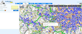
ViaMichelin has had traffic information available across most of Europe for several months now.
Their Blog seems a little dated. So here is a little update.

Via Michelin Oxford UK Traffic Info

Speed camera data is now available as an additional overlay - this data can be useful when overlaying the traffic data. The data for speed cameras is fairly up-to-date (apart from Swindon)
note: mobile 'safety' cameras are not mapped.

Via Michelin  Speed Camera Info

Other Geo-related (loosly) news:

ViaMichelin GPS Products


includes
Points of Interest:
Hotel and restaurant recommendations from the Michelin Guide, tourist locations from the Michelin Green Guide and thousands of useful and practical addresses throughout Europe

Safety Camera Locations: UK version or European version featuring Austria, Belgium, Czech Republic, France, Italy, Liechtestein, Netherlands, Poland, Portugal, Spain & United Kingdom.

MP3 Player for AudioTours (see below)

http://www.viamichelin.co.uk/viamichelin/gbr/GPS/htm/nav/gps.htm

ViaMichelin Local (geo-advertising)
Geolocated advertising for the tourism and leisure sector is now available.
http://local.viamichelin.com/?langue_choisie=en

ViaMichelin Geo-Tourism
This includes 'Green-Guides' and AudioTours
http://www.viamichelin.co.uk/viamichelin/gbr/dyn/controller/Tourisme
http://www.zevisit.com/NEWSVIAMICHELINUS/US/newsletter.html

Labels: , , , , , , , ,

09 April 2009

AA Real Time Speed Map England, Scotland & Wales

AA Real Time Speed Map England, Scotland & Wales

AA Real Time Speed Map
Real-time** Speed Mapped on Major Roads and Motorways in England, Scotland and Wales

**10 minutes out approximately

Though when try to zoom out it becomes a little heavy for the Web Browser

The Automobile Association [AA] developers might want to invest a little time investigating Cluster Markers.

Server-Sided Cluster Markers
http://maps.forum.nu/server_side_clusterer/

Javascript Cluster Markers
http://econym.org.uk/gmap/clusterer.htm [monitors the map movements ]

http://googlemapsapi.martinpearman.co.uk/readarticle.php?article_id=1

See the Real-Time Speed Map
http://www.theaa.com/traffic-news/index.jsp

Related Previous Posts
http://mapperz.blogspot.com/2008/11/new-aa-route-planner-beta.html

Labels: , , , ,

30 April 2008

192.com Boosts Spatial Local Searches

192.com Boosts Spatial Local Searches

The Search company that is investing in the power of Geographical Searching has now updated and integrated in to map based searching.

"192.com’s Local Search Solution merges its business records within mapping technology to bring local search to life. Businesses can now fully integrate 192.com’s mapping technology on to their sites by geo-coding their own data giving consumers an overall better user experience"

"...which has the ability to merge maps with over 4.5million business records and make this available to third parties"


192.com Search based on Map Area
Searching on the map quickly pulls local information to the user. Multiple search terms can be applied.

'192.com’s Local Search Solutions' default local services are:

  • Car parks
  • Banks
  • Hotels
  • Restaurants
  • Petrol Stations
This is along the lines of Yahoo new local search (see previous post)
This is the future of 'local' searching, very powerful and very fast.
(192.com contains over 630 million records)

Try it yourself
http://www.192.com/maps/
zoom in and enter a search term.

"192.com is the de facto standard search engine for finding people, business and places across the UK."

Mapperz

Labels: , , , ,

19 November 2007

ESRI ArcGIS 9.2 - Tips and Tricks (Updated)

updated 16/11/2007
So ArcGIS 9.2 and with Service Pack 4 installed.
and still going slow?

Here is Mapperz ArcGIS Tips and Tricks to get you more productive without the caffeine.

Okay Please note not supported by Mapperz but these methods 'help' ArcGIS run faster and give extra memory allocation.

You will have to log on your system as an administrator to make these tweaks

Before ArcGIS the Operating System should be tuned for ArcGIS.

Based on Windows XP Pro Starting Point

Make XP Run for ARCGIS better

RAM, Virtual Memory, Pagefile and all that stuff
http://support.microsoft.com/kb/555223

How to set performance options in Windows XP
http://support.microsoft.com/kb/308417/

Edit the Boot.ini My Computer>Properties>Advanced>Start Up and Recovery>Edit (Boot.ini)

/MAXRAM

If using an AMD Processor switch off 'Data Execution Protection'
* A common problem this is left on and some ArcGIS code is detected as 'bad' code therefore arcgis install will roll back
and unistall.

NOEXECUTE=ALWAYSOFF


http://www.microsoft.com/technet/sysinternals/
information/bootini.mspx

How to configure SQL Server to use more than 2 GB of physical memory
http://support.microsoft.com/kb/274750
SQL Server 2GB

Increases the size of the user process address space from 2 GB to 3 GB
(and therefore reduces the size of system space from 2 GB to 1 GB).
Giving virtual-memory
intensive applications such as database servers a larger address space can improve their performance

/3GB

so boot.ini looks like this

[boot loader]
timeout=30
default=multi(0)disk(0)rdisk(0)partition(2)\WINDOWS
[operating systems]
multi(0)disk(0)rdisk(0)partition(2)\WINDOWS="Microsoft Windows XP Professional" /noexecute=AlwaysOff /MAXMEM /3GB /fastdetect

Now install ArcGIS 9.2 with the service pack 4
(you can make these changes after you have installed ArcGIS)

Got Floating licenses?
If so and you want to share Arc/Info licenses but allow the user to use ArcGIS you can add ArcView single license to the Desktop Administrator.

It is very simple to do this. Just add the ArcView DVD to the DVD and got to install it. It will detect that ArcInfo is already installed and adds a component into desktop administrator.
Arc Desktop 9.2 Administrator

ArcGIS Improvements

C:\arcgis\Utilities\AdvancedArcMapSettings.exe
Change
Jet Engine to 120000 from the default 9600
This allows more records to be written from memory to shapefile/geodatabase


Printing Large Plots? (over 40 inches)
http://support.esri.com/index.cfm?fa=knowledgebase.
techarticles.articleShow&d=30516

Resizing from 42 inches to 60 inches
arcview\arcpress\etc directory
arcexe9x\etc\device1.dat file
To make the RTL drivers print wider than 36":
in the four lines beginning with 'RTL', change '10350' to '12150' to print 42" wide
'14550' to print 50" wide
and '17550' to print 60" wide

Finally got a PC with or over 2GB of RAM?
make the page file size bigger

Using RegEdit (Only do this if you know what it is)

HKEY_LOCAL_MACHINE\System\CurrentControlSet\Control\
SessionManager\MemoryManagement

c:\pagefile1\pagefile.sys 3000 4000
c:\pagefile2\pagefile.sys 3000 4000
c:\pagefile3\Pagefile.sys 3000 4000

Source:
Overcoming the 4,095 MB paging file size limit in Windows
http://support.microsoft.com/kb/237740


and a last tip is those pesky *.aux files that ArcGIS creates for raster display - delete them by a dos batch file and apply it to your start up (aux_delete.bat)

ECHO OFF
ECHO .
ECHO .
ECHO .
ECHO ***************************************
ECHO * *
ECHO * DELETING TEMPORARY AUX FILES... *
ECHO * *
ECHO ***************************************
ECHO .
ECHO .
ECHO ON
cd c:\data
cd d:\data
del *.aux /s
exit

*change c:\data & cd d:\data to your own raster locations

that should make ArcGIS go a little faster.

This post is a result of user experience and Microsoft Pages and ESRI Support.
Use at your own risk.

Use the ESRI Web Based Help - this is more up-to-date than the Installed version.

Labels: , , , , , , ,

24 September 2007

Route Scanner - Incidents and Delay Map

Route Scanner - Incidents and Delay Map

This is a fantastic UK Route Planner that works out delays, incidents and tells you the speed/traffic light camera locations along your own route.

Route Scanner created Paul Clark
Paul Clark has developed a clean and informative results page - Colour coded to severity (shades of red).
Uses the Google Maps API Driving Directions and Live Feeds from BBC Travel and the Highways Agency

Quick Guide
  1. Enter your start and destination.
  2. Choose a Buffer distance (1,2 and 5 miles)
  3. Choose Speed Cameras (Don't Show,Show Speed Cameras, Show All)
  4. Press 'Serach'

"Route Scanner uses live traffic information (e.g. accidents, roadworks and delays) combined with a route planner to calculate which incidents could affect that particular journey. It combines the power of Google Maps with the real-time information provided by BBC Travel and the Highways Agency. Route Scanner doesn't just look for traffic and travel updates on motorways and other major roads but through the road network."

Paul Clark also has developed other websites...
Well Done for creating an Excellent UK Mashup
Mapperz

Labels: , , , , , , ,

28 August 2007

FoxyTag - Speed Camera Locations Map

FoxyTag - Speed Camera Locations Map

Links speed cameras to map locations to mobile device

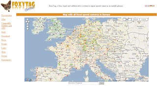
Speed Camera Locations Map

FoxyTag signals fixed and mobile speed cameras, data is updated every 5 minutes, the system works worldwide and is free.

Where does the data come from?
"FoxyTag is entirely collaborative (it is the users that post tags) and does not require any central operator to filter and validate data (it is done automatically). FoxyTag is a testing lab for future technologies and its main capital is its number of users."

more info

mapperz

Labels: , , , , , ,