->

27 July 2011

BBOX.ME (OSM to Google Earth) via FME

BBOX.ME (OSM to Google Earth) via FME
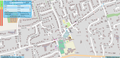
BBOX.ME (OSM to Google Earth) via FME
Left toolbar highlight large data download - red (large) amber medium and green is small data.
(OSM Servers will restrict large downloads automatically)

Take OpenStreetMap and via it's API, users can download an area of interest.

in this case:

"http:\\api.openstreetmap.org\api\0.6\map?bbox=-0.4994028225856829,53.73689294256218,-0.4839962145221512,53.74135397370099"

is requested from the OSM server via the OSM API.
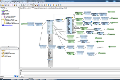
OSM FME Workbench
FME Workbench for converting to Google (or 3D PDF etc)
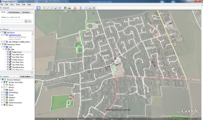
BBOX.ME OSM to Google Earth
Output is A clean representation of OSM in Google Earth - but with 3D Building Extruded from the data. This can also be viewed in Streetview in Google Earth.
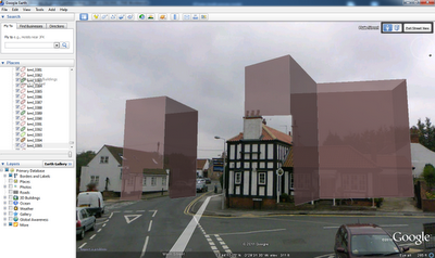
Extruded 3D Building (from Open Street Map) overlaid in Streetview in Google Earth
Extruded 3D Building (from Open Street Map) overlaid in Streetview in Google Earth.


This does use FME Desktop (a 30 day trail is available) which can convert the OSM files into Google Earth

Try BBOX.ME (created and founded by Peter Segersted and Ulf Mansson)
http://bbox.me/osm/

Labels: , , , ,

22 July 2011

Met Office - Storm Tracker Beta

Met Office - Storm Tracker Beta

Met Office Storm Tracker

The Met Office has created a new Google Maps Flash Map to monitor and forecast tropical storms around the world.

There are two versions of this map - Free and Premium (Paid For)

Free Version
· 1 x forecast weather layer (UK deterministic 5 day storm track)
· 1 x observed track
· 3 x latest weather layers:
· cloud (IR and Visible satellite)
· sea surface temperatures
· Thousands of historic storms (HURDAT data from 1850 until the present).

Advanced version (paid for service)
Additional premium content for an advanced service is available at a subscription rate.
The advanced service includes access to all the above, plus:
· Probabilistic forecasts of storms and weather – so a range of possible scenarios
can be understood
· Met Office 15 day ensemble forecast storm tracks; and equivalent data from
European Centre for Medium-range Weather Forecasting (ECMWF) and USA’s
National Oceanic and Atmospheric Administration (NOAA).
· Multi-model combinations of these leading models

· Additional forecasts for storms, including strike probabilities, forming storms, and
ensemble mean storm tracks
· A utilities layer showing district boundaries for the Gulf of Mexico
Access to these features enables users to build a far more complete picture

Users require to have an account (even for the free version) worldwide cloud conditions and the locations of current cyclones. If you select a cyclone on the map you can view the cyclone's observed track and wind speeds recorded along the track.

As well as viewing current tropical storm conditions it is also possible to view historical storm information. For example you can view the track of the 2009 Hurricane Bill.


Met Office Storm Tracker Historic Tracks


Storm Tracker Worldwide Map by the UK Met Office.
http://www.metoffice.gov.uk/premium/stormtracker/
(sign up and login required to view both free and premium)

Source:
http://googlemapsmania.blogspot.com/2011/07/worldwide-tropical-storm-tracker.html

Labels: , , , , , ,

20 July 2011

3D Buildings - Google Maps Expands Coverage

3D Buildings - Google Maps Expands Coverage
2.5D_Buildings Google Maps - London
Only 2.5D on the Google Maps sites (transparency induced)

But becomes true 3D on the Mobile device:

3D_Buildings Google Maps - London & Paris - Google Maps Mobile
3D London and Paris on the Google Maps Mobile - gives users a more realistic sense of location and bearing.

Now, 3D buildings are available in London, Paris, Barcelona, Stockholm, Singapore, Lisbon, Boulder, and 11 major cities in South Africa. These buildings will appear in both Google Maps and Google Maps for mobile.

Sources:
http://googlemapsmania.blogspot.com/2011/07/building-outlines-in-more-cities.html

More Info:
http://google-latlong.blogspot.com/2011/07/building-outlines-now-appearing-in.html

Labels: , , , ,

12 July 2011

Historypin Worldwide Launched

Historypin WorldWide Launched

Historypin Worldwide Launched

The Successfully UK London Launch in 2010 has now expanded worldwide.

Last year Historypin was beta in London. The historical photographs overlayed on Google Maps StreetView become very popular. Now officially launched with a new mobile applications and worldwide coverage.

"Historypin is a way for millions of people to come together, from across different generations, cultures and places, to share small glimpses of the past and to build up the huge story of human history.

Everyone has history to share: whether its sitting in yellowed albums in the attic, collected in piles of crackly tapes, conserved in the 1000s of archives all over the world or passed down in memories and old stories.

Each of these pieces of history finds a home on Historypin, where everyone has the chance to see it, add to it, learn from it, debate it and use it to build up a more complete understanding of the world."


http://www.historypin.com/

Source
http://googlemapsmania.blogspot.com/2011/07/historypin-goes-global.html

Labels: , , , ,

09 July 2011

#NokiaUnfenced Nokia X7 Testing

#NokiaUnfenced Nokia X7 Testing


A Tough Phone built for the Wild West....
Testing of the New Nokia X7 is going well, impressed with the solid build and speed of the new operating system.
Nokia X7 Testing
Stands out with a 4-inch AMOLED Screen - 8 megapixel Camera creates an impressive 3264 x 2440 pixels image (image from http://noknok.tv/) great for viewing HD videos and Photos.

The Nokia X7 is the only smartphone with a large Nokia 4-inch screen. The larger screen means movies come to life and playing games is a great deal more immersive [tested].
Screen size also views maps and navigation effortlessly. No QWERTY keyboard (uses the virtual keyboard sans input) then the Nokia X7 is the way to go.
#NokiaUnfenced Nokia X7 Testing

Symbian Anna Operating System
Symbian Anna is the latest version of the Symbian installed on the Nokia X7, delivering a faster and smoother user experience, quicker load times and a host of new features. Comes with a 680 MHz processor.
Unique Design and Solid Build.
If you like a solid metal feel to your phone own the Nokia X7. Too many smartphones simply look.The Nokia X7 is all about standing out from the crowd with its opt-angular sided styling. It’s a winner.

New Nokia Maps (3.08) Reviewed
This comes with a new version of Nokia Maps, 3.08. which brings a number of changes to the Drive (car navigation) functionality of the application. The new feature is the ab
utility to use live traffic information to automatically re-route you around traffic delays. New look and feel to the user interface ( have added "Just drive" mode), This version has can set a contact as a destination and an easier to use settings menu. The new beta also marks the brand switch from the Ovi Maps back to Nokia Maps.
Nokia Maps 3.08 beta is available for all Symbian 3 devices: Nokia N8, Nokia C7, Nokia C6-01, Nokia X7, Nokia E6 and Nok
ia E7.
New Nokia Maps 3.08 Reviewed
Faster Nokia Maps - And GPS Fix with assisted GPS is fast under 30 seconds.
(source of image All About Symbian)

Camera - X7 Camera Shots
http://www.flickr.com/photos/gletham/sets/72157627044792323/
by Glenn Letham


http://www.flickr.com/photos/roland/with/5920752728/

and Roland Tanglao


Plastic is dead bring on the stainless steel
Nice design, the age old plastic phones is gone a makes the smartphone sporting and good to hold. The stainless steel of the Nokia X7 adds sturdiness without compromising on weight. Expect a rugged life.

Follow updates throughout the weekend via twitter - #NokiaUnfenced

Big thanks to womworld/1000heads for their organising and hospitality so far. Post will be updated through the weekend.

Map of the Ranch with Photos..


Labels: , , , ,

06 July 2011

Tour de France Real-Time Map

Tour de France Real-Time Map

Tour de France Real-Time Map
Impressive Tour de France in Real-Time - almost on the spot - Map is real-time and covers Elevation and actual positions with speed:[kmh/mph] Cycle reps:[rpm] heart-rate:[bpm] and energy used in [watts].


http://data.srmlive.de/TDF/

Source:
http://googlemapsmania.blogspot.com/2011/07/live-tour-de-france-map.html

Labels: , , , ,

04 July 2011

Nokia 3D World Gaze

Nokia 3D World Gaze gives you a new kind of viewpoint to the world, allowing you to see through the surface (and inside) of the planet all the way to the other side. Just point your phone to some direction and you will see reality in a way you have never seen before. In addition to geographical features such as continents in their real physical locations, Nokia 3D World Gaze allows you to see geo-tagged media, day and night regions, current location of the Sun, and other content from locations around the world. (Like Augmented Reality)


New Dimension of Nokia 3D - World Gaze

The application is targeted to anyone interested in exploring and learning new things about the world around us. It provides a serendipitous view of the world and can be used anywhere on the planet. In fact, we encourage you to try it while traveling abroad: the world looks surprisingly different depending on where you are viewing it from.

Nokia are running the beta now to further improve the application and enhance it to better suit your needs. We are particularly interested in hearing your feedback on how you feel about this new way of looking at the world and what kind of new content you would like to see in the app.

Source:
http://betalabs.nokia.com/apps/nokia-3d-world-gaze

App available from
http://betalabs.nokia.com/apps

Labels: , , , ,