->

04 July 2011

Nokia 3D World Gaze

Nokia 3D World Gaze gives you a new kind of viewpoint to the world, allowing you to see through the surface (and inside) of the planet all the way to the other side. Just point your phone to some direction and you will see reality in a way you have never seen before. In addition to geographical features such as continents in their real physical locations, Nokia 3D World Gaze allows you to see geo-tagged media, day and night regions, current location of the Sun, and other content from locations around the world. (Like Augmented Reality)


New Dimension of Nokia 3D - World Gaze

The application is targeted to anyone interested in exploring and learning new things about the world around us. It provides a serendipitous view of the world and can be used anywhere on the planet. In fact, we encourage you to try it while traveling abroad: the world looks surprisingly different depending on where you are viewing it from.

Nokia are running the beta now to further improve the application and enhance it to better suit your needs. We are particularly interested in hearing your feedback on how you feel about this new way of looking at the world and what kind of new content you would like to see in the app.

Source:
http://betalabs.nokia.com/apps/nokia-3d-world-gaze

App available from
http://betalabs.nokia.com/apps

Labels: , , , ,

13 September 2010

World War Two: Battle of Britain Maps

World War Two: Battle of Britain Maps

"
MSN has teamed up with Shoothill to present an interactive overview of the Battle of Britain. Zoom into a mosaic of archive images and documents; compare present-day maps with maps and charts showing bomb damage during the Blitz; and view high-resolution Photosynths of iconic RAF aircraft."

This is one of the 'Best Bing Interactive Maps' for 2010 (and 1940)


World War Two: Battle of Britain Maps

The TimeMap is based on Bing Maps Silverlight Control. It shows original maps, reconnaissance imagery and target documents of the German Luftwaffe. You can navigate to various locations through quick links in a target list for London and Coventry.
  • The TimeScope can be dragged around to explore the location
  • The TimeSlider lets you switch between various historic maps and satellite imagery and the Documents.
  • DeepZoom - Compositions of the original target documents within the TimeScope.

Click for large view on the Map Controls, TimeSlider and TimeScope.

View the maps here:
http://news.uk.msn.com/in-depth/world-war-two/battle-of-britain/default.aspx

Labels: , , , , , , ,

22 October 2009

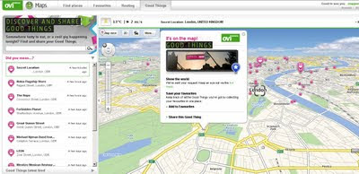
Nokia - Ovi Good Things

Nokia - Ovi Good Things

Nokia - Ovi Good Things
http://maps.ovi.com/goodthings/f84c5631-eec4-4ee6-8c04-872622dc1cb0/Secret-Location

(that's the location but you need a special token)

Labels: , , , , ,

02 July 2009

OpenFlights - Route Mapping The World

OpenFlights - Route Mapping The World

OpenFlights is a tool that lets you map your flights around the world, search and filter them in all sorts of interesting ways, calculate statistics automatically, and share your flights and trips with friends and the entire world (if you wish). It's also the name of the open-source project to build the tool.

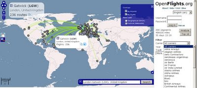
OpenFlights Routes Across the World

Search by Click the Icons on the Map or Airport Code, Airport Name or IATA Name- a very handy Aiport Map. Mapping base by OpenLayers

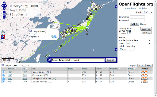
Note: Now, you can click on any airport and see every single scheduled flight:

Testing Stages:

OpenFlights has been going through Alpha, Beta and Gamma test phases, OpenFlights is now in its Delta phase: all core functionality is implemented, but development on new features continues. If you'd like to be informed about major updates to the site visit their blog


OpenFlights Routes Official Example

For easy access to this, we’ve added a Quick search widget, shown expanded above but normally hiding in the bottom-right corner under the icon. Here’s how to use it, in two easy steps:

  1. Enter the airport name, city or IATA code in the box. OpenFlights will automatically suggest matches as you type, and if the airport is already shown on the map, OpenFlights will pop it up.
  2. Once you’ve entered a valid name, the Search button becomes active. If you click on this, OpenFlights will load a route map showing all flights from that airport.

But there’s more! In the popup for every airport, there’s now a Routes button, which you can also use to see the map. If you click on the List button for the mapped airport (via popup or the top left corner), you’ll get a list of all flights operating from there; if you click on that button for another airport, you’ll get a list of all airlines connecting the two, even including codeshares.

Source and Image:

http://openflights.org/blog/2009/06/26/route-mapping-the-world/

Visit the OpenFlights Route Map


Labels: , , , , ,

15 June 2009

Nokia N97, Ovi Maps - The Mapperz Review

Nokia N97 Ovi Maps Review

"Ovi Maps is the new name for Nokia Maps."
Nokia have updated their mapping application.
Some good improvements and new content and new features and simpler cost structure.

Deleting Outdated Map Data
Old map data is recognised in the new software and will update the data, though depending on the amount of coverage you choose. Total for the entire world is towards 7GB. The UK is 156.5mb.
Pre-loading the maps will save you money in
'data transfer' costs over the mobile networks.

New Nokia Ovi Maps
Nokia Maps now Ovi Maps was updated last Thursday (11/06/09)

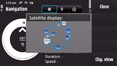
Satellite Status - BarSatellite Status - Radial
A quick note: Getting GPS Fixes faster. (less than a minute with 5 satellites
using standard GPS - no network based or A-GPS which uses the mobile
network to access GPS positional data)

The New N97 has more GPS details - in Applications>Location you can find
this in Position options Satellite Status will give you the signal strength of all
the GPS satellites available.
The view can be changed to Satellite display that gives the orbits on a radial
chart with sun and moon positions also. A nice feature, could this be implemented
in the Ovi Maps Application on the phone?

Back to the Maps:

What is New?
  • The map (vector) data has been completely updated
  • Current weather forecast information.
  • Speed Limit Warner
  • Saftey Spot Warner
  • Travel time or Time of Arrival option
  • Automatic 'Re-route' due to traffic option
  • Walking Directions has the option of straight-line distance to the destination.
  • Automatic 'Day/Night Time' Map mode.
  • Maps Improvement option.
  • *Compass mode (N97) Map rotates with you touch dragging (pan & zoom)
  • Search Nearby - vastly improved and more details available to users
  • Synchronisation with Ovi Maps Online. (confirmed this works very well)
  • Performance has been much improved (panning the map)
  • bugs fixed and is now a more stable application.
  • Better support and help - on phone or online option
Compass requires calibration before the function is available to use.


Traffic Information is now displayed on the Map even in 3D mode - Routes can be
automatic recalculated to avoid traffic incidents.

Smoothness, there has been a big improvement in the panning and zoom,
no jittering - when in driving navigating the map keeps up with the speed
of the vehicle. Navigation does repeat 3 times, one for advanced warning
- 350 yards. Then reminders at 50-30yds then 10 yards.

Walking mode does have the addition of straight line
'as the crow flies'
direction and distance.
(Golf players might use this to their advantage.)
Note the compass is 'green' meaning it is calibrated and active giving the
user the sense of bearing.
Walking Mode Straight line Navigation

Details on the map data:
v3.01 09wk24 b01 MV OpenGL LM MN
Map Version 0.1.22.103 OpenbitLM 6.21.3

Data souces:
NavInfo (Traffic info)
Satellite Imagemap 2002 - Planetary Visions
Imagery - Digital Global 2008
Aronbado por el Insitututo Geografico Milltar 5 Sept 2008.
STRM V4 2008 CIAT

update 25th January 2010 - New devices N97 (June 2009 onwards) Navigation is now Free
for life of the Phone. see
http://maps.nokia.com/explore-services/ovi-maps/downloads#/default/
Costs: (based on UK prices) - For Directions and Voice Navigation.
£52.99 for a year.(covers Europe).
£6.00 for 30 days.
£1.50 per day
*Pricing for other regions vary

1. Bug found: When using the 3D map option on the N97 - the touch screen only pans
upwards, the user cannot pan down the map.

Overall impressed with Nokia Ovi Maps 3 and where this application is going,
not only improving the software, the map data but introducing new and useful
features that engage and interacts with the user getting them to and from
locations conveniently.
Also the maps (vector data from Navteq now Nokia owned) are more up-to-date
than many online mapping
sources including TeleAtlas etc. (which Google uses).
At least areas that Mapperz has tested in so far.

This is the final beta stage of Ovi maps version 3. Expect the full release
in the next few weeks for
all current nokia phones that can support the application.

SportTracker Users will be happy to know that this is working for the N97 with
the touch screen controls.
Please visit Symbian World for more on this:
http://symbianworld.org/1187-sports-tracker-finally-
available-for-nokia-n97-and-5800/

Ovi Maps is a free application for S60 devices, though extra features
'Directions and Voice Navigation'
require licences that can be purchased
through the application.
More information
http://betalabs.nokia.com/betas/view/nokia-maps-30-maps-ovi

More details on the N97 Mapperz recommends:
http://www.allaboutsymbian.com/reviews/item/Nokia_N97
_Review-Part_1-First_impressions.php

http://www.allaboutsymbian.com/news/item/9902_Nokia_N97
_Review-Part_2-Touch-.php

A very special thanks to the team at http://www.womworld.com/nokia/
for a very successful 'Search for N' competition.


Labels: , , , , , , , , ,

05 June 2009

Bing Maps Silverlight - World Tour

Bing Maps Silverlight - World Tour

Bing Maps Silverlight World Tour

"Microsoft will announce the latest imagery updates to its Bing Maps platform, which for the first time, can all be viewed using the brand new ‘Bing Maps World Tour’ application. Just about every month, Microsoft adds tens of terabytes of new content to Bing Maps, bringing new locations to life and reinvigorating pre-existing areas with fresh, high resolution imagery. Now, thanks to Silverlight and Windows Azure technology"

To see a live example of this (silverlight plug-in required)
http://bingmapsupdates.cloudapp.net/

YouTube Video of it in action.


Source with thanks to:
Guy McGerr
www.webershandwick.co.uk

Labels: , , , ,

20 August 2008

Free Maps for Education (in PDF format)

Free Maps for Education (in PDF format)

Maps International
have release free maps in A3 paper size
(297mm×420mm or 11.7''×16.5'')

Maps International Educational Free Maps - Europe
Politically coloured Europe map for Free

Maps International Educational Free Maps - World
This World Map is available for educational use at not cost.
(Politically coloured World map with hill shading and bathymetry.)

"Maps International Education shop provides education wall maps and geography teaching resources and aids for all ages. Our product range is extensive and includes the new exclusive Primary Schools wall maps. Also available to purchase are key geography texts for higher and further education including subjects such as Earth Sciences, Regional and Area Planning and many more Geography based subjects."

Other Free Maps available:
  • UK map with major transport links including motorways, primary routes, ferry routes and airports.
  • UK map with major transport links including motorways and airports.
  • UK map with parliamentary boundaries and names.
  • Wales map with country/ county/ district/ unitary boundaries and names
  • Scotland map with country/ county/ district/ unitary boundaries and names
  • England map with country/ county/ district/ unitary boundaries and names.
  • Europe map with hill shading and hypsometry.
  • Outline black and white World map with country borders, capitals and country names.
  • Outline black and white World map with country borders only.

These Maps in PDF format are available from
http://www.mapsinternational.co.uk/education_downloads.asp

TERMS OF USE
All material is copyrighted and should not be reproduced for commercial use. If you intend to use the free resources for anything other than classroom use, then contact Maps International on Free Phone 0800 038 6277 or sales@mapsinternational.co.uk to discuss the cost and royalties applicable. No responsibility can be assumed for the accuracy of the information given.

Labels: , , , , , , , , ,

25 May 2008

Biggest GPS Self Portrait in the World

Biggest GPS Self Portrait in the World

GPS Self Portrait
55 days,over 100,000 km and 62 countries later...


"Artist Erik Nordenankar says he has created the Biggest Drawing In The World. He says he gave DHL a case and travel instructions for a 55-day journey, then traced the route using GPS. The route was more than 100,000km long and went through 62 countries. The result was a self-portrait."

Labels: , , , ,

08 February 2008

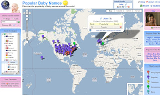
Popular Baby Names World Map (Beta)

Popular Baby Names World Map (Beta)

Popular Names World Map

http://www.babynamemap.com/

Guy Davis has updated a very clear and fast map of popular names around the world.

"I wanted to send out a big Thank You to the Google Maps developers for creating a great tool and making it easy to build applications upon. Ever since the API was announced I've been looking for an opportunity to build something useful with Google Maps. When I found out that my wife and I were expecting our first child, my searches for popular baby names yielded a bunch of sites with boring old static HTML tables of data.
So instead, I've aggregated popular baby name statistics and show them on a Google Map which makes exploring this dataset a lot more interesting. If you're interested, check out the Baby Name Map at:
http://www.babynamemap.com

Hopefully others will find the map useful as well. Keep up the great work on the API. I look forward to incorporating more new features into the map. "
From the Google Maps API forum and receiving lots of positive responses


New features are:
Floating windows
  • Tab panes
  • Dynamic trees
  • Interactive data tables
  • Flags of the world (tree directory)

"The new tree of countries makes it easy to navigate around the map and let me make use of some more interesting features of Google Maps. Now I need to update the map with some of the recent 2007 statistics."

Mapperz suggestion - Google Maps API with Google Chart API might work very well with this type of information, comparing names and statistics with location.

Labels: , , , , ,

18 January 2007

NeoEarth - Blog Visitors by World Map

NeoEarth - Blog Visitors by World Map

These seem to get flasher...


Available from neoworx.net (NeoEarth)
Compare Free

  • Basic display past 24 hours visitors.
Premium
  • Detailed display
    All online and past visitors
  • Fully customizable
    12 maps each in 4 sizes
  • Exclusive Day/Night feature
  • Full-scale map allowing detailed navigatio

Labels: , , , , ,

21 November 2006

Cartograms Updated - WorldMapper

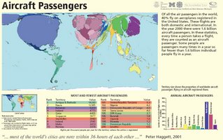
Based in the Geography department at the University of Sheffield they been busy creating new cartograms.

Cartograms Updated - WorldMapper
Also available to view in PDF format like the image above (Aircraft Passengers)
Too many too list but here is a link to the end of the index

Labels: , , ,