->

14 January 2011

ABC Community Queensland Flood Map

Updated: 14/01/2011 6.10pm
The ABC has launched an interactive map of the Queensland flood. Please 'Submit a Report' about what's happening in your area. The map includes both verified and unverified reports. Please note, this is an experiment in gathering information from the community.

ABC Community Queensland Flood Map
It works like this: you send us information, either by email (qldfloodsmap@gmail.com), text message or Twitter (simply use the #qldfloodsmap hashtag on your post) .

More Information
http://queenslandfloods.crowdmap.com/main

Map
http://queenslandfloods.crowdmap.com/


ESRI have also released "ESRI Australia - Brisbane City Council Flood COP - Situational Awareness Application"
Australia ESRI Flood Map
http://www.esri.com/services/disaster-response/australia-flooding-map-2011/response-map.html

Labels: , , , ,

17 November 2010

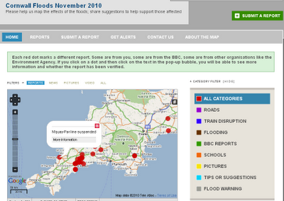
Cornwall Flooding - November 2010

Cornwall Flooding - November 2010

Cornwall Flooding November 2010

Submit a Flooding Report
Cornwall Flooding November 2010 Submit


About This Project

"This is an experimental project created by BBC Cornwall to map reports of the floods. We will add our reports but we'd love you to add your experiences and your tips for helping the community."

You can submit a report by:

a) Sending an email to radio.cornwall@bbc.co.uk

b) Sending a tweet with the hashtags #cornwall #flood or #floods

c) Filling in the form on this site http://cornwallfloods.crowdmap.com/

When you send your reports or comments, they will be put up on the map.


http://cornwallfloods.crowdmap.com/

Labels: , , , ,

24 July 2007

MyMaps Helping to Map UK Floods

Update

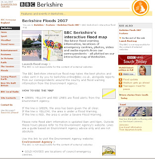
BBC Berkshire's interactive flood map

"The latest flood warning information, locations of emergency centres, photos, video and audio reports from our correspondents - all plotted on our interactive map of Berkshire."

BBC Berkshire's Interactive Flood Map

BBC Berkshire Flood Map Feature

MyMaps helping Map UK Floods and useful up to date information

BBC Berkshire flood Map using Google My Maps
This MyMap records the flooding in Berkshire


The Power of MyMaps is use to display visually and geographically
Thanks to Ed Parsons for finding a map that is more useful and up to date than the Official Government Websites.
Bowser Map using Google My Maps
This map shows the bowsers available in Gloucester and Cheltenham

The cause of the flooding seems to be pointing at the jetsteam shifting south more than normal El Niño and La Niña (the rising and lowering of pressure and temperature in the pacific ocean)
could be possible causes, though human impact seems to cause more fluctuations in this natural process

Jet Stream over the UK in  June 2006Jet Stream over the UK in  July 2007
Images: BBC and the Met Office

Labels: , , , , , , ,

23 July 2007

UK Flooding Links

Update 2
London could be next to see severe flooding

Floods Could Hit London Next

"More than an inch of rain is set to drench the city and this rain, combined with the water that has already poured into the Thames, could burst the river's banks in southwest London.

A flood warning is already in force in Staines and Shepperton, and hundreds of homes could be flooded in the next 24 hours."

Source: Sky News


Update the BBC has created a Map of the Flooding

BBC Flood Map
Source: BBC News

Rivers affectively in severe flood:
  • The Severn: Severe Warnings for Gloucester, Tewkesbury and Worcester
  • The Thames: Severe warnings affecting Eynsham to Sandford Lock and also Little Wittenham
  • The Ock: Severe warnings from Charney Bassett to Abingdon
  • The Great Ouse: Severe warnings from Turvey to Sharnbrook
  • The Avon: Severe warnings at Evesham


UK Flooding helpful links looking for flooding infomation

Tirley flooding near Tewkesbury
Tirley near Tewkesbury (Sky News)

Okay to help users find pictures for the UK Flooding, Mapperz compiles the most useful links...
(this site has been hit hard for 'UK Flood' Maps)

Environment Agency (but not live data)

Best News Coverage so far is Sky News
(updated pics ever hour)

Peoples Flood pics (BBC Content)

Bedfordshire
Travel conditions

Gloucestershire
Travel conditions

Worcestershire (includes Herefordshire)
Travel conditions

Oxfordshire
Travel conditions

If your wanting maps of the floods, your out of luck, currently there are no public out of copyright maps available online that shows live information.

More Flood News

Hope you stay dry - Mapperz

Labels: , , , , , , , ,

27 June 2007

Sky News - UK Flooding Map (Pics)

Update - if your looking for UK Floods in Southern, West and Midlands [20th July to 24th July 2007]
Go to the newer page
http://mapperz.blogspot.com/2007/07/uk-flooding-links.html


Sky News UK Flooding Map showing pictures of the Flooding in the North of England - News has Location.


Sky News UK

More and more Maps are Illustrating news events - giving the users a sense of the scale of the matter.
(other parts of the UK have been affected - though the North of England has had it very bad.)

Source: Google Maps Mania via Press Gazette

More Flooding Pictures from the BBC Site

Labels: , , , , ,

26 June 2007

Environment Agency - Adds Pollution Maps

Environment Agency - Adds Pollution Maps
(as well as Flooding)

Environment Agency Pollution Maps

You can now select individual polluting gases and their location that can be define and find more information about the substances
example
Carbon Dioxide

Main Sources of Air Pollution


  • Air quality and emissions
    Find out how air quality has changed over time, and how emissions of different substances impact on the environment and health.

  • Air pollution incidents
    In 2005 154 pollution incidents had a serious impact on air quality in England and Wales, the lowest number on record.

  • Acid rain
    Acid rain has been tackled for over a decade with some success.

  • Ozone depletion
    Ozone in the upper atmosphere shields the earth from harmful ultra violet (UV) radiation emitted by the sun. Man-made chemicals have damaged this “ozone layer”, allowing more UV radiation to pass through.

Other Sources of Pollution


  • Pollution incidents - Pollution incidents such as oil spills or the accidental release of raw sewage can damage the environment, harm wildlife and pose a threat to human health.

  • Ozone depletion- Ozone in the upper atmosphere shields the earth from harmful ultra violet (UV) radiation emitted by the sun. Man-made chemicals have damaged this “ozone layer”, allowing more UV radiation to pass through.

  • Acid rain - Acid rain has been tackled for over a decade with some success

  • Noise - Noise from industry, traffic and homes can annoy, disturb sleep and affect health.

  • Light pollution - Light pollution has reduced our ability to view the night sky and causes impacts on wildlife. England is more brightly lit than other European country with the exception of the Netherlands.

  • Environmental Crime - Illegal activities can directly harm wildlife or the environment. This section covers breaches of permits and fly tipping.

  • Nutrients in rivers, lakes and coastal waters - Nutrients are essential for aquatic life, but high levels can upset ecosystems, create unsightly algal blooms and even threaten our health.

  • Fertilisers - Fertilisers must be used with care to avoid pollution.

  • Pesticides
And they still deal with flooding. But check your local area - the data and mapping for flooding is a little dated in places.

Environment Agency Flood Maps
EA vs OnOneMap Technologies
Comparing Environment Agency 'Mapping' (not data) with OnOneMap
Users prefer ease of use with OnOneMap.

Labels: , , , , ,