->

07 April 2010

Digimap for Schools

New Digimap® data supply service for GB Schools
GB (Great Britain England, Scotland & Wales) but not Northern Ireland Schools

updated 8th April with correct details - many thanks to Emma Sutton (Geoservices Support Coordinator) EDINA
Ordnance Survey please update your PDF the right details.
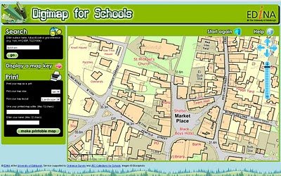
Digimap for Schools
Schools will be able to print A4 or A3 Maps from the Online Service coming soon. Teachers will be able to teach children the importance of maps in a much easier 2011 fashion.

http://digimapforschools.edina.ac.uk

So this is why 1:25,000 Explorer Maps & 1: 50,000k Landranger Maps are not part of OpenData from Ordnance Survey.

Cost:
£60 for primary schools, and from £75–£125 for secondary schools.
  • Includes Ordnance Survey's OS MasterMap®, the most detailed mapping available for Great Britain, with over 450 million features from the built and natural landscape such as building outlines, pavement edges, walls and fences, house numbers, ground cover, benchmarks and much, much more.
  • Offers complete coverage of Great Britain mapped at 1:10 000 scale and showing street names.
  • Provides a seamless digital map covering all 403 sheets in the OS Explorer Map series (1:25 000 scale), all 204 sheets in the OS Landranger Map series (1:50 000 scale) and regional maps at 1:250 000 and 1:1 million scales.
  • Includes map keys and a search gazetteer with over 250 000 place names.
  • Maps can be located using postcode or place name searches, with a series of progressively more detailed map views available.
  • Maps can be titled by users before printing at either A4 or A3 size in portrait or landscape format.
  • Map content is updated annually.
  • Unlike paper maps, digital maps can be centred on your school or place of interest.

"The web interface gives a generous map area and has been designed to so that pupils can easily find maps themselves. Digimap for Schools supports maps skills teaching in geography, and has many wider cross-curriculum uses. It is the next step for pupils and teachers who generally use paper maps but are now looking for the flexibility of using digital mapping within a safe-surfing environment."

Digimap for Schools is designed to provide access to mapping, but is not a GIS.
Digimap for Schools is available via subscription for an annual charge of £60 for primary schools, and from £75–£125 for secondary schools.
Free trials available, sign up and more information at http://www.jcs.nen.gov.uk/catalogue/digimap.html

Map skills are also included as a key skill in the new Primary Curriculum, due for implementation in England from September 2011 under ‘Historical, geographical and social understanding’. Use of maps is considered to be ‘essential knowledge’ for developing understanding of how and why places and environments develop, how they can be sustained and how they may change in the future.

source: [big PDF with some image errors]
http://www.ordnancesurvey.co.uk/oswebsite/education/mappingnews/previouseditions/ed37.pdf [outdated]
info
http://www.jcs.nen.gov.uk/catalogue/digimap.html
more info
http://digimapforschools.edina.ac.uk/cosmo/faqs

Labels: , , , , , , ,

09 March 2010

New Google Geocoding Web Service

New Google Geocoding Web Service

The service is now 'not limited' but you are required to show the results on a Google Map.
Examples given to help user understand the importance of this update.
Lots of updated content and improvement from feedbackNew Service v3 Geocoding
  • Unlimited Usage*
  • Status Codes (in Plain English!)
  • Java Support (Parsing XML with XPath)
"*Note: the geocoding service may only be used in conjunction with a Google map; geocoding results without displaying them on a map is prohibited."
[2,500 requests may be sent to the Geocoding Web Service per day from a single IP address]

but purley for example based on the official example given
Geocoding London (UK)
http://maps.google.co.uk/maps/api/geocode/xml?address=London&sensor=false
New Google Geocoding Web Service

Reverse Geocoding 51.5001524,-0.1262362 (London)
http://maps.google.com/maps/api/geocode/xml?latlng=51.5001524,-0.1262362&sensor=false

Countries Support
http://spreadsheets.google.com/pub?key=p9pdwsai2hDMsLkXsoM05KQ&gid=1
Note: en-GB ENGLISH (GREAT BRITAIN) enabled

New Status Codes - now in Plain English
  • "OK" indicates that no errors occurred; the address was successfully parsed and at least one geocode was returned. example
  • "ZERO_RESULTS" indicates that the geocode was successful but returned no results. This may occur if the geocode was passed a non-existent address or a latlng in a remote location. example
  • "OVER_QUERY_LIMIT" indicates that you are over your quota. (your geocoding too fast!)
  • "REQUEST_DENIED" indicates that your request was denied, generally because of lack of a sensor parameter. example
  • "INVALID_REQUEST" generally indicates that the query (address or latlng) is missing. example
Now for the new content:

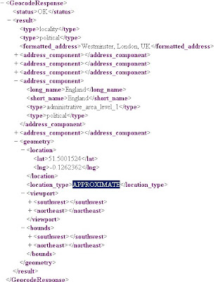
geometry contains the following information:

* location contains the geocoded latitude,longitude value. For normal address lookups, this field is typically the most important.
*location_type stores additional data about the specified location. The following values are currently supported:
o "ROOFTOP" indicates that the returned result is a precise geocode for which we have location information accurate down to street address precision.
o "RANGE_INTERPOLATED" indicates that the returned result reflects an approximation (usually on a road) interpolated between two precise points (such as intersections). Interpolated results are generally returned when rooftop geocodes are unavailable for a street address.
o "GEOMETRIC_CENTER" indicates that the returned result is the geometric center of a result such as a polyline (for example, a street) or polygon (region).
o "APPROXIMATE" indicates that the returned result is approximate.
* viewport contains the recommended viewport for displaying the returned result, specified as two latitude,longitude values defining the southwest and northeast corner of the viewport bounding box. Generally the viewport is used to frame a result when displaying it to a user.
* bounds (optionally returned) stores the bounding box which can fully contain the returned result.

Java Support
Parsing XML with XPath

Although it is not as lightweight as JSON, XML does provide more language support and more robust tools. Code for processing XML in Java, for example, is built into the javax.xml packages
please see http://code.google.com/apis/maps/documentation/geocoding/#XMLParsing for full details.

Full Documentation (updated)
http://code.google.com/apis/maps/documentation/geocoding/
Official Blog Post
http://googlegeodevelopers.blogspot.com/2010/03/introducing-new-google-geocoding-web.html
Mano Marks (Google Geo Developer Advocate)
http://randommarkers.blogspot.com/2010/03/client-side-geocoding-rocks.html

Full terms and conditions
http://code.google.com/apis/maps/terms.html#section_10_12
Maps API Terms
http://code.google.com/apis/maps/terms.html

Labels: , , , , , ,

09 July 2009

Ericsson Web & Mobile Maps API (Labs)

Ericsson Web & Mobile Maps API (Labs)

Use Web Maps to embed powerful and flexible maps into your web applications.

  • Powerful map component easily embeded into any web page
  • Custom layers with your own objects and symbols
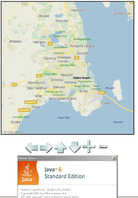
  • Embedded Java Applet with dynamic map rendering in the browser
  • Easily integrated Javascript interface
  • Automatic fall back to Javascript only version for browsers that doesn’t support Java Applets
  • Free access to map data (TeleAtlas - Vector data)

Ericsson Web Maps - Java

The Ericsson Web Maps API (Labs) uses Java for the mapping (javascript- fallback if no java available), first load can be a little slow at times.

Working Example

http://saudi.betainnovation.com/controls.html

Web Maps provide dynamic maps which you can integrate into any web application and features a large variety of control possibilities and overlay of symbols. The maps are rendered in a Java Applet which provides fast map browsing and smooth and animated interaction.

The dynamic rendering also let’s you control the look and feel of the map and how your users interact with it.

Currently limited in Mapping Examples. Users would be encouraged to create their own.

More information on the Web Maps API:

https://labs.ericsson.com/apis/web-maps/documentation

Mobile Version (also with an API)

"Mobile Maps is Java based and available both for Java ME and for Android. You download the Java ME or Android library, which provide the functionality of downloading, displaying, and interacting with maps to your applications. It also includes access to the map data itself."

Key Point with the Mobile Maps Version is:
"Through its unique functionality of rendering the maps in the mobile phone application Mobile Maps use very low bandwidth in comparison to many other map services and applications."

Mobile Maps is powered by Idevio and Tele Atlas


More information
https://labs.ericsson.com/apis/mobile-maps/

Source: (Also mentions the new SMS Send & Receive API)
http://blog.programmableweb.com/2009/07/04/5-new-apis-sprint-ericsson-and-volunteerism/

Labels: , , , , , , , ,

16 April 2009

Google Maps Adds Web Cam Layer - New!

Google Maps Adds Web Cam Layer - New!

Google Maps Web Cam Layer
Live Web Cams within Google Maps as a new layer in the 'More' tab.
Click the thumbnail images to view a live webcam - local time zones apply.

Labels: , , , ,

13 March 2009

English Lake District [3D Tours]

Lake District Information [3D Tours]

English Lake District  3D Map Helvellyn
"The site is intended to offer information about this area, in addition to providing maps, views and virtual tours of its villages, lakes and mountains. These are intended to enhance your appreciation and enjoyment of the Lake District."


The site also uses Google Earth to overlay walking routes in addition to information of mountain features on many of the Lake Districts Fell.

"This site uses the Google Earth Plug-in on a number of pages. This innovative software presents us with a fresh way of viewing the Lake District from a range of new perspectives. You can view 3d image models of the mountains and valleys, and take guided tours around the villages and lakes. You are also free to visually navigate around the district going wherever you choose. I have found this a great way to get to know Lakeland in intricate detail."

*Google Earth Browser Plug-in Required.

A good starting point

http://english-lake-district.info/virtual-tours/village-virtual-tour.html

A few tours (there are more...)

Lakes Tour

Villages Tour

Helvellyn Tour

The tours seems very smooth and works well with users.

More Info: http://english-lake-district.info/index.html

Labels: , , , , ,

19 November 2008

CloudMade Web Lite API (pre Alpha)

CloudMade API (pre Alpha)

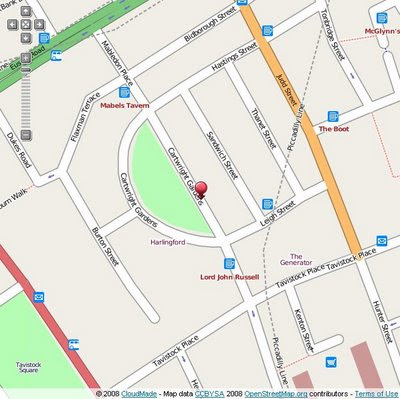
"Our [CloudMade] aims are to continue the democratization of geo data and to expand access to open geo data through a range of simple yet powerful tools and APIs."

CloudMade Web Lite API
Early Days but looking promising in the 'lite' way to get web mapping on your site without the large restrictions other mapping api's have.

Now there is two Mapping API's that are in early stages of development.

Web Lite - API
http://www.cloudmade.com/products/web-maps-lite

Features:
  • Take advantage of the most up-to-date source of map data on the web
  • Benefit from the rich OpenStreetMap dataset, with features such as footpaths and cycle paths that are not found on other online maps
  • Be free from restrictive licensing - use our maps for routing, real time tracking and as a basemap to derive new layers
Mobile Maps API*
http://www.cloudmade.com/products/mobile-tiles
Features:
  • Create applications for mobile devices that use CloudMade's mobile optimized maps
  • Benefit from the rich OpenStreetMap dataset, with features such as footpaths and cycle paths that are not found on other online maps
  • Take advantage of the most up-to-date source of map data on the web
*untested by Mapperz currently

Examples:

Try the drag marker with panning and zooming functionally added.
http://mapperz.googlepages.com/cloudmade_web_lite_api.html


speed test onload: 0.85 milliseconds (YSlow!)

To test it - Mapperz used the OSM data in Virtual Earth as a comparison
http://mapperz.googlepages.com/osm_in_VE.html
speed test onload: 1.25 milliseconds (YSlow!)

Yes currently the bigger API's have more functionality but their Terms restrict in what you can and cannot do with your mapping, so the future for a lightweight Mapping API is looking good.

Web Maps Lite API is currently in 'closed pre-Alpha'
Let's look forward to a Public Beta.

Though you can view the Official Step-by-Step Examples
http://www.cloudmade.com/products/web-maps-lite/examples/1

Another good move by Cloudmade is the OSM data

"This is where you can find extracts of maps from different places around the world. From here you can download:"

  • OSM XML extracts by country
  • Garmin Map Files (OSM.err edition)
  • Osmosis country bounding polygon
  • Shapefile extracts by country
  • Navit maps by country
  • GPX POI by country
  • TomTom POI by country
  • OSM XML feature extracts by country
http://downloads.cloudmade.com/

Labels: , , , , , , ,

11 August 2008

Where is the Path? - 3D

Where is the Path? - 3D

A recent update which includes the option of 'Earth' (Google Earth inside the web browser)


Allows the user to create a route of their choice and view it in 3D - attribution of the points is available.
Export to GPX for input into a GPS device.
*Earth plugin must be installed to view the content.
In the drop down list select OS+Earth

There is a limit on the number of Ordnance Survey tiles per a 24 hour period (30,000 tiles) - keep an eye on the percentage bar in the bottom left corner.
OS please raise this limit to 50k or higher.

http://wheresthepath.googlepages.com/wheresthepath.htm

Full credit goes to Bill Chadwick for producing this nifty side-by-side mapping application.

Labels: , , , , , ,

02 July 2008

ArcGIS 9.3 Web-based Help Now Available

update 02/07/2008 (7pm)

best and worst of the Help

Great to see the ArcGIS 9.3 Help up and running for all users now.

One thing I have noticed is the ‘Geoprocessing Center’ promised is either late coming or still out of date…(anyone know anymore?)

http://mapperz.blogspot.com/2007/06/esri-users-questions-answered.html

The best updated function so far is the 'Near' Command (ArcInfo Only)
Supporting Input points,lines, polygons and multipoint.
(a long time request)

http://webhelp.esri.com/arcgisdesktop/9.3/index.cfm?id=1273&pid=1268&topicname=Near_(Analysis)

old version only supported points as an input

http://webhelp.esri.com/arcgisdesktop/9.2/index.cfm?id=1111&pid=1107&topicname=Near_(Analysis)

Mapperz (via the James Fee 'Spatially Adjusted' Blog Comments

ArcGIS 9.3 Web-based Help Now Available


ESRI finally have updated their Support pages with 9.3 web-based Help

Quick picks

PDF Support (Acrobat 9.0)
(export with layers and attributes)

Postgres Connection
(via ArcSDE)

ArcGIS 9.3 Shortcuts

Animation of Data

And finally ArcGIS understands nominal scales!
(wiki)

so now One inch = 5 miles works. (thank you ESRI)


ESRI 9.3 Help now 'out of beta' and available for all to view and use.

New Features and Helpful 'error' messages have plain English explanations

http://webhelp.esri.com/arcgisdesktop/9.3/index.cfm?TopicName=welcome

The final build number for ArcGIS 9.3 is Build 1770
via Mandown (NZ)

Labels: , , , , ,

29 May 2008

Google Earth API Arrives! (The Web Browser Version)

Updated 29th May 2008 - With Examples (3D Plugin Required)

A few minutes ago after this updated post- Mapperz has an email from Rob at Map Channels with this updated See Bournemouth Map with the 3D Google Earth Maps.
Google Earth 3D - See Bournemouth Maps
The New Google 3D Maps Live and Working on
http://www.seebournemouth.com/GoogleMap.aspx

Well Done Rob and full credit for integrating this so quickly - more like this please.


Click the Earth [Map Type] option next to Terrain

Google Earth API Arrives! (The Web Browser Version) WOW!

Another prediction from Last Year has finally
made it.
Google Earth Web Browser Version (FireFox)
This a image is not from Google Earth Desktop but Firefox.

http://code.google.com/apis/earth/

more soon...

Here are some New Examples
Google Earth Web Version Options
http://mapperz.googlepages.com/3Doptions.html
Taken from
http://www.google.com/earth/plugin/examples/options/

Allows you to define a location and set different option (Grid, Navigation, Status Bar etc)


What is required?
Not much - but there is a 3D plugin needed to view the new 3D Earth

Google Earth Web Browser Version Plugin Require for 3D
The Free Plugin is needed if you want to view the 3D Earth.

That's it, enjoy...

For Fun Test out the Monster Milk Cart (Fast PC/Mac with a Fast Internet Connection needed when going super fast)
Other Examples to get you going
http://code.google.com/apis/earth/documentation/examples.html

Mapperz

Labels: , , , , , ,

14 March 2008

Google Sky (Web Version) Released

Google Sky (Web Version)

Google Sky
Google have just released Google Sky (Web Version) - Works in the same way as Google Maps does, but you now look up from the Earth to view the Sky at Night.


Google Sky Web Version
Google Sky Web Version (English UK)
Date Collected from:
Digital Sky Survey
Digitized Sky Survey
Hubble Space Telescope.

"Select the thumbnail images at the bottom of the display to bring up the planets, the constellations, highlights from the Hubble Space Telescope, famous stars, galaxies and nebulae, views of the universe in the x-ray, ultraviolet and infrared"

Other items available through Google Sky:

Backyard Astronomy - Highlights the stars, galaxies and nebulae that can be seen with a pair of binoculars or a small telescope. These placemarks tell you about the celestial objects as well as providing links to sites such as Google Scholar where more detailed information can be found
Infrared - An infrared view of the sky from the Infrared Astronomical Satellite (IRAS). Change the transparency of this layer by moving the slide bar to blend the optical and infrared.

Microwave - A view of the microwave sky from NASA's Wilkinson Microwave Anisotropy Probe (WMAP), which shows the universe as it was 380,000 years after the big bang.

Historical - The sky as drawn by Giovanni Maria Cassini (printed in 1792) showing the constellations in their classical form from the collections of David Rumsey

Is the imagery different from Sky in Google Earth?
The images seen in Google Sky are identical to those found in Sky in Google Earth. Google have changed the projection to display these images within Google Maps (the Mercator projection). As with Google Maps this means that the northern and southern celestial pole cannot be shown.
Source: Google Sky Help Pages

Official Google Blog: http://googleblog.blogspot.com/2008/03/space-jam.html
Lat Long Blog: http://google-latlong.blogspot.com/2008/03/organizing-more-than-one-worlds.html

Labels: , , , ,

28 June 2007

Map Your Picasa Web Photos

Map your photos

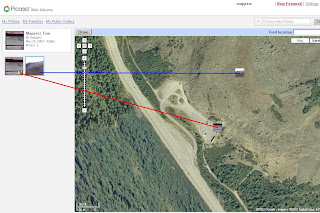
See your photos arranged on a map, and show friends exactly where you took your best pictures. Simply type a location into the ‘Place Taken’ field when creating a new album, or refine a photo’s placement using a drag-and-drop map. It’s a great way to share photos from a summer vacation or road trip.

Example (Official)

Source: Googlified

Mapperz Demo

Geotagging (Georeferencing) Photos in Picasa New Feature

To manually Georeference your photos, select the album and view map enter a rough location, then centre the map and zoom in to where you remember the photo was take. Pick up the photo thumbnail and drag it across the map. Then the Latitude and Longitude is automatically assigned to the image. Simple as that.


Labels: , , , ,

04 December 2006

The Possible Future of Web Mapping

An Interesting Article
http://datamining.typepad.com/data_mining/

Get Mapping Terrain
Nearly as if being there yourself...

GetMapping

Labels: , ,