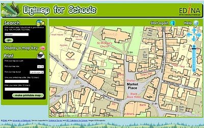
Digimap for Schools
New Digimap® data supply service for GB Schools
GB (Great Britain England, Scotland & Wales) but not Northern Ireland Schools
updated 8th April with correct details - many thanks to Emma Sutton (Geoservices Support Coordinator) EDINA
Ordnance Survey please update your PDF the right details.

Schools will be able to print A4 or A3 Maps from the Online Service coming soon. Teachers will be able to teach children the importance of maps in a much easier 2011 fashion.
http://digimapforschools.
So this is why 1:25,000 Explorer Maps & 1: 50,000k Landranger Maps are not part of OpenData from Ordnance Survey.
Cost:
£60 for primary schools, and from £75–£125 for secondary schools.
- Includes Ordnance Survey's OS MasterMap®, the most detailed mapping available for Great Britain, with over 450 million features from the built and natural landscape such as building outlines, pavement edges, walls and fences, house numbers, ground cover, benchmarks and much, much more.
- Offers complete coverage of Great Britain mapped at 1:10 000 scale and showing street names.
- Provides a seamless digital map covering all 403 sheets in the OS Explorer Map series (1:25 000 scale), all 204 sheets in the OS Landranger Map series (1:50 000 scale) and regional maps at 1:250 000 and 1:1 million scales.
- Includes map keys and a search gazetteer with over 250 000 place names.
- Maps can be located using postcode or place name searches, with a series of progressively more detailed map views available.
- Maps can be titled by users before printing at either A4 or A3 size in portrait or landscape format.
- Map content is updated annually.
- Unlike paper maps, digital maps can be centred on your school or place of interest.
"The web interface gives a generous map area and has been designed to so that pupils can easily find maps themselves. Digimap for Schools supports maps skills teaching in geography, and has many wider cross-curriculum uses. It is the next step for pupils and teachers who generally use paper maps but are now looking for the flexibility of using digital mapping within a safe-surfing environment."
Digimap for Schools is designed to provide access to mapping, but is not a GIS.
Digimap for Schools is available via subscription for an annual charge of £60 for primary schools, and from £75–£125 for secondary schools.
Free trials available, sign up and more information at http://www.jcs.nen.gov.uk/catalogue/digimap.html
Map skills are also included as a key skill in the new Primary Curriculum, due for implementation in England from September 2011 under ‘Historical, geographical and social understanding’. Use of maps is considered to be ‘essential knowledge’ for developing understanding of how and why places and environments develop, how they can be sustained and how they may change in the future.
source: [big PDF with some image errors]
http://www.ordnancesurvey.co.uk/oswebsite/education/mappingnews/previouseditions/ed37.pdf [outdated]
info
http://www.jcs.nen.gov.uk/catalogue/digimap.html
more info
http://digimapforschools.edina.ac.uk/cosmo/faqs
Labels: Digimap, Great Britian, Ordnance Survey, Primary, Schools, Secondary, Service, Web


0 Comments:
Post a Comment
<< Home