->

01 September 2010

New BBC Travel Maps (Beta)

New BBC Travel Maps (Beta)

New BBC Travel Maps (Beta)
Improved Navigation and live feeds (jamcams included), much better Travel News from the BBC.

http://www.bbc.co.uk/travelbeta/birmingham/

What's new:
  • Updated design, with wider pages and larger text.
  • Improved navigation, allowing movement between adjacent geographic areas
  • Interactive mapping, which can be minimised if you prefer the text incident list
  • Clearer timestamping of incidents.
  • Traffic jam cams showing frequently updated still images of traffic conditions on motorways and trunk roads
Addional Improvements
  • The text incident list has been updated to improve readability, and is synchronised with the map.
  • Local weather forecast from the BBC Weather Centre for the next 6 hours from now
  • Backend improvements to our data-handling system to categorise data, and speed up the reception and delivery of data to the site.

What's not changed:
  • BBC's comprehensive traffic and travel information remains at the core of the service, updated around the clock
  • The text list remains, and you can hide/minimise the map, to put the functionality of the site back to the way it used to be.
  • BBC have made the redesign as subtle as possible, in order to retain the things you've told us you like about the existing site.
  • In the final version of the site, you'll be able to click to see a country-wide motorways or major roads overview from every page.
  • BBC's door-to-door journey planner, powered by Transport Direct, remains but has been made more prominent.

Why a new version of BBC Travel News:

"Firstly, to update the design to take advantage of the BBC's wider page layout, introduce maps across the site for the first time, and make some basic improvements to the presentation of our information
Secondly, to improve the data-handling processes behind the scenes, to allow us to separate the data into more useful groups, and reduce the time it takes for the data to reach you
Thirdly, to integrate traffic jam cameras (where available) into the main BBC Travel News website alongside our incident data"

Current BBC Travel Maps (Beta) Areas:

Birmingham beta
Black Country beta
Coventry beta
Herefordshire beta
Shropshire beta
Staffordshire beta
Warwickshire beta
West Midlands beta
Worcestershire beta
Wolverhampton beta

Labels: , , , ,

09 March 2010

New Google Geocoding Web Service

New Google Geocoding Web Service

The service is now 'not limited' but you are required to show the results on a Google Map.
Examples given to help user understand the importance of this update.
Lots of updated content and improvement from feedbackNew Service v3 Geocoding
  • Unlimited Usage*
  • Status Codes (in Plain English!)
  • Java Support (Parsing XML with XPath)
"*Note: the geocoding service may only be used in conjunction with a Google map; geocoding results without displaying them on a map is prohibited."
[2,500 requests may be sent to the Geocoding Web Service per day from a single IP address]

but purley for example based on the official example given
Geocoding London (UK)
http://maps.google.co.uk/maps/api/geocode/xml?address=London&sensor=false
New Google Geocoding Web Service

Reverse Geocoding 51.5001524,-0.1262362 (London)
http://maps.google.com/maps/api/geocode/xml?latlng=51.5001524,-0.1262362&sensor=false

Countries Support
http://spreadsheets.google.com/pub?key=p9pdwsai2hDMsLkXsoM05KQ&gid=1
Note: en-GB ENGLISH (GREAT BRITAIN) enabled

New Status Codes - now in Plain English
  • "OK" indicates that no errors occurred; the address was successfully parsed and at least one geocode was returned. example
  • "ZERO_RESULTS" indicates that the geocode was successful but returned no results. This may occur if the geocode was passed a non-existent address or a latlng in a remote location. example
  • "OVER_QUERY_LIMIT" indicates that you are over your quota. (your geocoding too fast!)
  • "REQUEST_DENIED" indicates that your request was denied, generally because of lack of a sensor parameter. example
  • "INVALID_REQUEST" generally indicates that the query (address or latlng) is missing. example
Now for the new content:

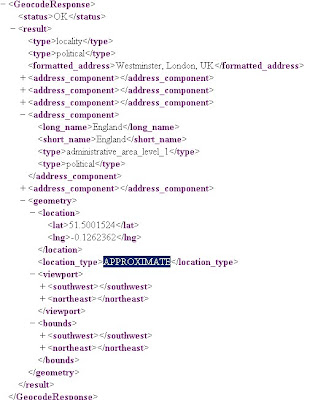
geometry contains the following information:

* location contains the geocoded latitude,longitude value. For normal address lookups, this field is typically the most important.
*location_type stores additional data about the specified location. The following values are currently supported:
o "ROOFTOP" indicates that the returned result is a precise geocode for which we have location information accurate down to street address precision.
o "RANGE_INTERPOLATED" indicates that the returned result reflects an approximation (usually on a road) interpolated between two precise points (such as intersections). Interpolated results are generally returned when rooftop geocodes are unavailable for a street address.
o "GEOMETRIC_CENTER" indicates that the returned result is the geometric center of a result such as a polyline (for example, a street) or polygon (region).
o "APPROXIMATE" indicates that the returned result is approximate.
* viewport contains the recommended viewport for displaying the returned result, specified as two latitude,longitude values defining the southwest and northeast corner of the viewport bounding box. Generally the viewport is used to frame a result when displaying it to a user.
* bounds (optionally returned) stores the bounding box which can fully contain the returned result.

Java Support
Parsing XML with XPath

Although it is not as lightweight as JSON, XML does provide more language support and more robust tools. Code for processing XML in Java, for example, is built into the javax.xml packages
please see http://code.google.com/apis/maps/documentation/geocoding/#XMLParsing for full details.

Full Documentation (updated)
http://code.google.com/apis/maps/documentation/geocoding/
Official Blog Post
http://googlegeodevelopers.blogspot.com/2010/03/introducing-new-google-geocoding-web.html
Mano Marks (Google Geo Developer Advocate)
http://randommarkers.blogspot.com/2010/03/client-side-geocoding-rocks.html

Full terms and conditions
http://code.google.com/apis/maps/terms.html#section_10_12
Maps API Terms
http://code.google.com/apis/maps/terms.html

Labels: , , , , , ,

15 August 2007

ArcGIS Explorer - Build 410 Released

ArcGIS Explorer Build 410

Improvements - it's smoother

Result Properties
source: ESRI

* When a result is generated it has a default zoom extent, or view. The default view is from an overhead perspective. You can capture a new view by moving and/or tilting to a new perspective, then using the result property sheet to capture the new view. The view property is persisted with the result.

Navigation with ArcGIS Explorer has been enhanced in the following ways.

Observer Elevator Movement: By default, zooming in and out on the map using the mouse or keyboard will zoom relative to the target location. Holding down the Ctrl-key and using the + and – keys will change the observer elevation. This is similar to traveling up and down in an elevator. This type of movement is useful for viewing vertical features in your map at differing elevations.

Zooming to Cursor Position: Zooming to a location on the map has been enhanced by zooming to the mouse pointer position. You can still zoom to the center of the map by holding down the Ctrl-key while scrolling the mouse wheel. Zooming out always occurs from the center of the map.

Look Replaces Pan at Tilt Angles Larger Than 45 Degrees: In previous versions of ArcGIS Explorer, double clicking on the map when viewing the map tilted beyond 45 degrees would center the clicked location. This often changed the distance from the observer location to the target. Now when the map is tilted beyond 45 degrees, a double-click will use the Look functionality, changing the observer's view without changing the observer position.


* Subsurface Navigation
To get a subsurface view of the earth, tilt your map then hold down the Ctrl key and use the + or - keys to move straight down below the earth or to move straight up.


* Easier Navigator Access
Access to the Navigator is easier; the target area which maximizes the control has been made larger.


* Faster Opening of Server Folders
The performance of opening servers publishing services in multiple sub-folders has been improved.


* Improved Stars
Stars now appear as different sizes and are centered at the observer position to illustrate their correct location, providing a more realistic appearance for the sky and globe.


* Close Shortcut
The keyboard shortcut which closes the application is now Alt-F4 to adhere to standard shortcut conventions.

* Point measurements and point notes now store the view properties captured at the time of their creation. For example, when you add a point note the current view will be captured and stored with the note. You can double-click the note to zoom to the specified view. The view properties can be edited through the result property sheet


* New Find Address task replaces the previous Find Address task found in earlier builds. The new task provides the capabilities to enter address or place in a single input from which it will be parsed and matched.

The Find Route and Get Driving Directions tasks provide a convenient drop down menu allowing you to choose which language to display your directions and routes. The following languages are supported: Danish, Dutch, English, French, German, Italian, Norwegian, Portuguese, Spanish, and Swedish

Free Download
http://services.arcgisonline.com/410/explorer/software/downloadpage.html
(No login required)

Labels: , , , ,

18 June 2007

Better European Driving Directions - Yahoo Maps

Yahoo Maps are now providing better European driving directions.


Now you can cross borders and sea's and get accurate driving times (exclude traffic jams) to places right across Europe. The Example shows from Belfast to Galaţi (Eastern Romania) Stopping off in Paris (for a croissant) will take you 41 hours and 8 minutes (approx).

Driving directions within 34 European countries include:

Western Europe - Complete coverage
Austria, Belgium, Denmark, Finland, Germany, Great Britain, Luxembourg, Netherlands,
Ireland, Norway, Portugal, Spain, Sweden, Switzerland, France, and Italy.

Eastern Europe – Comprehensive coverage
Albania, Bosnia/Herzegovina, Bulgaria, Croatia, The Czech Republic, Estonia, Greece, Hungary
Latvia, Lithuania, Macedonia, Poland, Romania, Russia, Serbia/Montenegro, Slovakia, Slovenia, and Turkey

Redesigned interactive print page makes it easier to print and read driving directions.

Yahoo will introduce new in-country Maps sites in France, Germany, Italy, Spain and the UK.

(You can already take a look at Yahoo! Maps India, currently in beta)

Labels: , , , ,