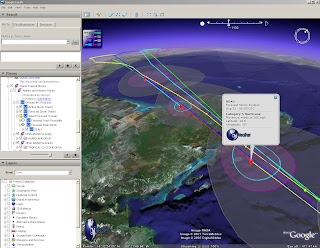
Hurricane Dean - Mapped and Tracked
Final Update:
The storm has reached Category Five, the highest strength, with winds of up to 160mph (255km/h).

Radial Zones show destructive path of Hurricane Dean at Category 5
For a Visual Understanding - view the Hurricane Animated guide from the BBC (in Flash)
Update 3:
Dean is now forecast to slam into Belize and the east coast of Mexico's Yucatan Peninsula, including the popular tourist destination of Cancun.
http://news.sky.com/skynews/article/0,,30200-1280456,00.html?f=rss
Update 2:
meteorological reports the storm could intensify into a Category Five hurricane in the next few hours.
http://news.bbc.co.uk/1/hi/world/americas/6954296.stm
"Dean is now expected to pass close by the low-lying Cayman Islands, before hitting Mexico in the coming hours"
Update:
For more information
http://www.nhc.noaa.gov/#DEAN
Currently Category 4
"Winds 131-155 mph (114-135 kt or 210-249 km/hr). Storm surge generally 13-18 ft above normal. More extensive curtain wall failures with some complete roof structure failures on small residences. Shrubs, trees, and all signs are blown down."
There is potential for this hurricane to be upgraded to category 5...eek!
" Dean is now over very warm water and in an ideal situation to strengthen further."
Rob McElwee, BBC Weather
Hurricane Dean - Mapped and Tracked

View live updated content for Hurricane Dean with predicted courses based on category (currently 4).
The KMZ for Google earth comes with more information.
- Oil and Gas Fields
- Buoys (Windspeed, pressure etc)
- Sea Temperatures (very important with hurricanes)
- Clouds (Shows the scale of the hurricane)
- Predicted Routes/Modeled Forecasts
more information from GraphOilogy Blog
Link to the KMZ (the latest release of Google Earth is required which is 4.1.1087.5048)
Labels: Google Earth, Hurricanes, KMZ, Mapped, Tracked, update, updated


0 Comments:
Post a Comment
<< Home