->

17 August 2010

BBC Dimensions (Prototype) Mapping

BBC Dimensions (Prototype) Mapping

BBC Dimensions is an experimental prototype for the BBC. We want to bring home the human scale of events and places in history. The D-Day landing beaches measured from London to Norfolk in the UK. How far would the Titanic stretch down your street?

"Dimensions simply juxtaposes (side by side) the size of historical events with your home and neighbourhood, overlaying important places, events and things on a satellite view of where you live. Certain "Dimensions" can be transformed into short walks, so you can get a physical appreciation of the distances involved."
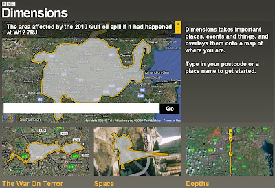

BBC Dimensions howbigreally map
Use your Postcode or Town to recenter the map and see in scale terms historical events with this map tool.

How do you make the Dimensions maps?

We've built a system that can quickly take scale illustrations of historical events and superimpose them on zoomable, clickable maps. Information designers at the BBC research and produce these illustrations based on a range of library and on-line resources to make them as accurate as possible. If you think it got something wrong, get in touch. http://howbigreally.com/contact/

BBC Dimensions example maps

More Examples of events across the globe are available.

Can I make a Dimensions map?

The BBC hope to open up the ability to create Dimensions maps in a future version, so that local historians, experts and enthusiasts can use it as a tool for communicating what they know.

What's next for Dimensions?

BBC will evaluate the prototype based on your feedback, and hopefully integrate it into the BBC's online history and news coverage

Try the BBC Dimensions (Prototype) Mapping

http://howbigreally.com/

Labels: , , , ,

23 June 2010

Met Office Events Weather Maps

Met Office Events Weather Maps

Whether your interested in The World Cup in South Africa, Wimbledon Tennis Championships or the Music at the Glastonbury Festival the Met Office has released weather map events.

Met Office Weather Events Glastonbury Map
Check out the Glastonbury Temperature, UV, Pollen Forescast weather is continously updated to provide you with warning (Thunderstorms, high ultraviolet rays and hopefully sun.)

Met Office Weather Events Wimbledon UV Map
See UV Sun Index guidance with the interactive symbols on the Wimbledon Weather Map


"The World Cup finals will, for the first time, be taking place in Africa, with South Africa playing the host nation for what is regarded as the world's largest sporting spectacular.

The tournament is taking place between 11 June 2010 and 11 July 2010.

The Met Office are providing a weather forecast for the venues of the World Cup finals, click on the weather symbols on the map to get more detailed information on the venue of interest. "

Met Office Weather Events World Cup Map
Looks like Sunny all the way in South Africa for the World Cup 2010.

Map Links
http://www.metoffice.gov.uk/public/pws/events/worldcup/
http://www.metoffice.gov.uk/weather/uk/wimbledon.html
http://www.metoffice.gov.uk/weather/uk/glastonbury.html

Source:
http://www.metoffice.gov.uk/public/pws/events/

update: 24th June 2010
Met Office News - Press Release on these Events
http://www.metoffice.gov.uk/corporate/pressoffice/2010/pr20100624.html

Labels: , , , , , , ,

11 December 2009

Planning a big event? - Marquee Venues Mapped

Planning a big event? - Marquee Venues Mapped

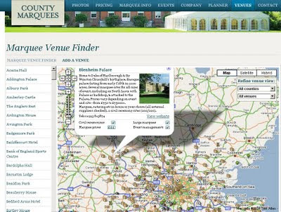
There are maps for almost anything, here is a site that can give you access to marquee sites and locations in South East England.
These are for small to very large events (weddings, rock festivals, sport events and corporate events.

Marquee Venues Mapped
Numerous locations that can accommodate large marquee events

http://www.countymarquees.com/venues.htm

This site does well due the integration of locating, planning events and gives clear and full specifications of all types of marquee's available.

In additional users can update this map with locations that accommodate these large shelters.

Geographical Areas covered:
  • London
  • Sussex
  • Surrey
  • Oxfordshire
  • Kent
  • Hampshire
  • Essex
  • Hertfordshire
  • Berkshire
  • Bedfordshire
  • Buckinghamshire
Equipment

Map

Neat 'undercover' Marquee Planner

Labels: , , , , , ,

25 September 2008

Map Channels Events - New!

Map Channels Events - New!

Map Channels Events - New
Find sporting events or concerts by location fast.

Map Channels is an exceptional website portal and provider of a range of free mapping tools and custom mapping services:

It has now expanded and now integrates events, mapping and ticket purchase in one website.

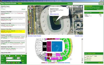
Map Channels Events Paris
Quickly locate events all over the world and select the event by map or city search, also different currencies are supported.

"A world of events at your fingertips"
• Interactive event calendars and venue maps
• Find events by name, category, date or location
• Ticket price comparison
• View city tours, attractions and activities
• Explore venues with Google Street View and Google Earth

Well done the Map Channels Team [again]
To see their progress visit http://mapchannels.com/News.aspx

Labels: , , , , ,

09 August 2007

Open Street Map - Cycle Map

Open Street Map - Cycle Map

Open Street Map - Cycle Map
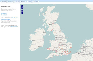
A nice implementation 'in progress' using free data. A positive move to community based mapping and you can see the results from this map.

The Cycle Map is based on data from the openstreetmap project. At low zoom levels it is intended for overviews of the national cycle network; at higher zoom levels it should help with planning which streets to cycle on.
Key:

  • Routes in red are national cycle routes.
  • Routes in blue are local cycle routes.
  • Cycleways are shown in green and yellow.
  • Toucan crossings are shown as green circles.

An up and coming event for UK Cartographers
Society of Cartographers - 43rd Annual Summer School 3rd - 6th September 2007
http://www.port.ac.uk/special/soc/

Programme Details are available from
http://www.port.ac.uk/special/soc/programme/

The 'Learning Technologist' Richard Treves interviews the Chairman of SOC has a blog called
http://googleearthdesign.blogspot.com


Labels: , , ,

22 May 2007

BBC, Nokia & Ymogen = GeoStories

News has location
BBC, Nokia & Ymogen team up to create GeoStories

GeoStories is a project combining GPS, News and Innovation together. Students from Brighton University have started this unique project.

This is a very likely and useful way of reporting news and adding location to the story.


Geo-Stories Project
GeoStories uses Google Maps to show locations of events per story

"Ymogen are working with Nokia and BBC Innovation to produce Geo-Stories, an innovative 'citizen story' project, which explores how content (video, pictures and text) combined with location and time can most effectively be used to create crowd pulling stories."

Nokia N-series mobile phone(s) are used to store location and record video and geotagged photos

View the GeoStories

Posted by Mapperz in Canada

Labels: , , , , ,

21 February 2007

Google Map Public Calendars

Google Maps Public Calendars

Google Maps Public Calendars
example
http://www.google.com/calendar/events?q=Marathon
&ql=London&qt=&qtd=&sa=N&page=vl&afp=393d85a865eecf88

A New Feature in Google Calender is to be able to search Public Calenders and Events

"Now you can search the web for events and add them directly to your Google Calendar. Within Google Calendar, type an event search into the search box like "Symphony in San Francisco" and click "Search Public Events". You'll see a list of events that you can easily add to your Google Calendar."

more new features
http://www.google.com/intl/en/googlecalendar/new.html

There is also a Google Calendar API

The Maps for calendar only work when the user has inputted the location of the event.
All Events should have a location, therefore should be mapped.

Source:Mapperz

Though please remember Google Calendar is still Beta.

Labels: , , , , ,