->

17 June 2010

New! Explore Yell.com in 3D Photo-real Maps UK

New! Explore Yell.com in 3D Photo-real Maps UK

Yell_Beta_Photo_Real_3D_Cities_UK
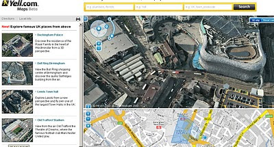
3D Photo-real imagery comes to a few cities in the United Kingdom in Yell Maps Beta.

"In a UK-first, the photo-realistic 3D maps were created from actual film footage shot from light aeroplanes using sophisticated aerospace technology, which is then merged with other film taken from ground level. They can be used for free on the Yell.com website, which is the online version of the Yellow Pages directory. "

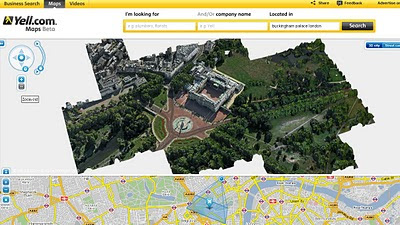
Yell Beta Photo Real 3D Cities UK - Buckingham Palace
Rendering in 3D Buckingham Palace.
Discover the residence of the Royal Family in the heart of Westminster from a 3D perspective.

View the Bull Ring shopping centre of Birmingham and discover the quirky Selfridges building from the air.


Explore Leeds from a new perspective and fly over one of the largest Town Halls in the UK.


View from the air Old Trafford the Theatre of Dreams, where the famous football club Manchester United play.

Full Url to the Birmingham Bullring

Source:
Slashgeo

Labels: , , , , , ,

22 March 2010

Online Spatial Database Clouds - SQL Azure

Online Spatial Database Clouds - SQL Azure
(spatial database support coming due to demand of user feedback)

SQL Azure Spatial POI Along Route
Using a Spatial database (SQL Azure) to find Gas (petrol) Stations along a route.
New Functionality - Azure Spatial Database Support using cloud computing related topic - http://en.wikipedia.org/wiki/SQL_Azure


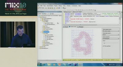
Last Wednesday (March 17th), Dave Robinson of the SQL Azure Team announced upcoming support for spatial data in SQL Azure. You can view the announcement at the MIX Conference in the video of Dave’s presentation, Building Web Applications with Microsoft SQL Azure (go to 18:40 on the timeline for the start of the spatial data portion of his talk).
SQL Azure - Spatial Buffer
Spatial buffering a polyline - but across the web (not local database) - Windows SQL Azure will have spatial capabilities - to be released April 2010.

"SQL Azure provides a highly available and scalable relational database engine in the cloud. In this demo-intensive and interactive session, learn how to quickly build web applications with SQL Azure Databases and familiar web technologies. We demonstrate how you can quickly provision, build and populate a new SQL Azure database directly from your web browser. Also, see firsthand several new enhancements we are adding to SQL Azure based on the feedback we’ve received from the community since launching the service earlier this year."

This uses the same technology as Microsoft SQL 2008 Server
basically it supports latitude and longitude.

A "Flat Earth" (GEOMETRY or planar) data type represents geospatial data which has been projected from its native, spherical, coordinate system into a plane.
A "Round Earth" data type (GEOGRAPHY) uses an ellipsoidal model in which the Earth is defined as a single continuous entity.

source:
Video
http://live.visitmix.com/MIX10/Sessions/SVC07 (46.45) jump to 18.36if have no time.

Related blog
http://blogs.msdn.com/edkatibah/archive/2010/03/21/spatial-data-support-coming-to-sql-azure.aspx

SQL Azure Labs
http://blogs.msdn.com/sqlazure/archive/2010/03/19/9981936.aspx

Labels: , , , , , , , ,

01 January 2010

Met Office Data - Visualisation with Maps

Met Office Data - Visualisation with Maps

See the power and innovation of Opening up Government Data.
*in less than a month.

In late 2009 the UK Government launched an Open Data initiative, headed by Sir Tim Berners-Lee, along with a call for innovations challenging the developer community to make this data more accessible.
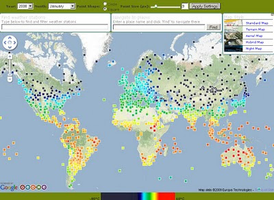
Geo.me Temperature Map
Geo.me Solutions is showcasing a number of concept demonstrations using map-based visualisations. Like the Temperature Map Above.

The Met Office might supply xml/rdf based data in the future.
But to get the raw data into a useable format Chris Wallace and assistance from Dave Challender make it available now.

Met Office Data Temperature Mashup
All the Met Offices data linked via xml to the stations data.

Background of the Data released last month by the Met Office
Land surface climate station records

The data down-loadable from this page are a subset of the full HadCRUT3 record of global temperatures, which is one of the global temperature records that have underpinned IPCC assessment reports and numerous scientific studies.

The data subset consists of a network of individual land stations that has been designated by the World Meteorological Organization for use in climate monitoring. The data show monthly average temperature values for over 1,500 land stations
http://www.metoffice.gov.uk/climatechange/science/monitoring/subsets.html


Now the Visualising of the data....

Met Office Temperature Mashup Chart
Temperature data that is interactive with the user temperature/timeline with a static map of the location.

Climate Data - An XML/XQuery implementation
Introduction

The UK Met Office recently released the temperature records for about 1600 stations world-wide. Each station record is available online as a text file, for example Stornoway.

"It is expected that longer-term, the MET office itself will make the data available in more readily programmable format. In the meantime, this site offers a number of XML-based resources for access to the data."

The station data and temperature record is available in two forms:


Source
http://www.cems.uwe.ac.uk/xmlwiki/Climate/index.html
http://labs.geo.me/climate_trends

So UK Government opening up the data will encourage innovation and business - so get on with open up the data - by April 2010 (please).

Labels: , , , , , ,

25 October 2008

New BBC Weather Maps (Beta v1.0)

New BBC Weather Maps (Beta v1.0)

New BBC Weather Beta Maps
The BBC are looking into revamping thier current weather service for 2009.
The are currently looking into adding more interactive features the visual weather portal.


New Features: *subject to feedback and beta status.
A 'one-stop shop' (no need to wait for another page to load)
Better Navigation to Maps in the users 'area of interest'
Flash based maps - animation is smoother and faster [tested with Flash Player 10]
More updates from the Met Office = Better accuaracy and currency of weather.
More localised weather particularly in the United Kingdom.

New BBC Weather Beta - North America Pressure Maps
Maps are now embedded in Flash - faster loading and smoother animations.

BBC Weather is now location based vs the old version by type of forecast.

"all forecast information is now organised by location rather than by type of forecast it might look like there is less information on the site."

More to be added in later beta versions
"The map presenter will also be more interactive and you will be able to view maps for surrounding areas without leaving the page. Later in 2008 we will be adding embedded video forecasts."

"We are currently sourcing forecast temperatures for coastal waters and will add these to the site when they are ready."

Try the BBC Beta Weather Maps
Click to See BBC Weather Beta Maps
(click the image to view)

Please review the site and request new features like - georss, archive weather maps by date, 3D option, transparent overlays (cloud+radar etc) are just a few as examples.
maybe rainfall charts, wind factor, chill factor...

More information
http://www.bbc.co.uk/weather/bbcweather/features/website_redesign.shtml

Mapperz

Labels: , , , , , ,

22 May 2008

Nokia Maps 2.0 Goes Mainstream

Nokia Maps 2.0 Goes Mainstream

Finally after many months of 'Beta' status the Nokia Maps 2.0 has made it available to the normal users.
Nokia Maps 2.0 Goes Mainstream
So whats changed?
Well from version 1.0 lots but from the 2.0 beta version not very much (a few bugs)

A quick summary:
Car Navigation
Pedestrian navigation
Multimedia city guides

Car Navigation has navigation carousel with three pre-defined navigation views (navigation, arrow and bird-eye) with multi-stops route planner.

(Purchase required based on region 3 day, 1 month, 1 year subscriptions - there is a option for 3 days free trial - this now tied to the SIM card not the IMEI of the Phone - meaning if you change your phone you can keep you licence.)
SIM to SIM licence copying can be done.

Satellite images
Hybrid mode


**Note these two modes use either Wifi or GPRS for displaying the layer they DO NOT come with the MapLoader pre-installed onto a memory card.

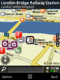
Nokia Maps 2.0 Goes Mainstream - London Bridge

Nokia Maps 2.0 uses digital vector data provided by Navteq and TeleAtlas
Either download directly to the nokia device or by using the Nokia Map Loader on a PC. Nokia Maps 2.0 and the current commercial version of the Nokia Maps Loader are freely available for selected devices.

Downloads
Nokia Maps 2.0
http://europe.nokia.com/A4984199
(select your device)

Nokia Map Loader v1.3.8 (for Vista/XP on the PC - use this to save money on data transfer fees)
If your feeling brave there is a new beta version of Nokia Maps 2.0

Created Feb. 11, 2008 but updated on May 08, 2008
nokia_maps_2.0_1803_3.1_u.sis
http://www.nokia.com/betalabs/applications


Other Nokia useful applications recently released.

Nokia Step Counter
Nokia Step Counter New! [Free]
Every step you take

Location Tagger (Updated) [Free]
http://www.nokia.com/betalabs/locationtagger

Mapperz

Update of Nokia Maps 2.0 source:
http://www.infosyncworld.com/news/n/9390.html

Labels: , , , ,

18 March 2008

UK Debt Maps

UK Debt Maps

UK Debt Map Experian via the BBC News

http://newsvote.bbc.co.uk/1/hi/business/7301082.stm

"Nearly a third of the 5.7 million new problems dealt with by staff at Citizens Advice bureaux in 2006-7 concerned debt, making it the biggest single issue they faced."

Most indebted
1. Richmond-upon-Thames
2. Putney
3. Kingston-upon-Thames
4. Windsor
5. Wandsworth
Least indebted
1. Dumfries
2. Chesterfield
3. Merthyr Tydfil
4. Skegness
5.Bangor


Highest rises
1. Penzance
2. Bromley
3. Skipton
4. Eastleigh
5. Bromsgrove
6. Abergavenny
7. Newbury
8. St Helens
9. Beverley
10. Newark On Trent

PDFs (hosted on the BBC Site)
Total Debt Levels (2mb)
Year on Year Change (2mb)

Mortgage Debt (2mb & spot the mistake!)
Credit Card Debt (2mb)

Sources: BBC News
Experian and Experian Micromarketer G3

Labels: , , , ,