->

29 January 2010

Mobile GeoRSS Maps *Beta* (Map Channels)

Mobile GeoRSS Maps *Beta* (by Map Channels)

"The easy way to add mapping for mobile websites"

Mobile GeoRSS Maps combines the Google Maps v3 API and Google Feeds API to display a GeoRSS feed on a map that is optimized for mobile phone display.
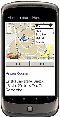
Mobile GeoRSS Maps
Create your own Map with feeds for your mobile, mymaps or georss feeds can auto-update and provide you with latest information whilst on the move.

Use Mobile GeoRSS Maps to simply add your map to your mobile website, or to generate a map link for emailing.

Google My Maps are supported. Use Mobile GeoRSS Maps to generate a mobile version of a My Map in seconds.

Mobile GeoRSS maps works on any phone which supports the Maps v3 API, such as the iPhone and Android or Symbian platforms.
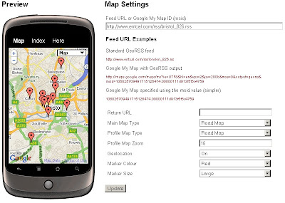
Mobile GeoRSS Maps Preview
Simple instructions to set you up for adding your own feeds to your mobile.

Technical Notes:

This map is a *beta* project, please contact us if you notice any bugs.

Only placemarks in a feed are displayed (lines and polygons are not displayed)

A maximum of 200 placemarks are displayed on the map

Custom Marker styles contained in a My Map are not displayed

base url for the following parameters
http://data.mapchannels.com/mobmap/100/map.htm

f = Feed URL or My Maps ID
r = Return URL
mt = Main Map Type (1=Road Map, 2=Satellite, 3=Hybrid, 4=Terrain)
pt =Profile Map Type (1=Road Map, 2=Satellite, 3=Hybrid, 4=Terrain)
z =Profile Map Zoom (between 1 and 20)
g =Geolocation (0=Off 1=On)
c =Marker Colour (0=Red 1=Blue 2=Green 3=White)

example:
http://data.mapchannels.com/mobmap/100/map.htm?g=1&mt=1&pt=1&z=16&c=0&s=1&f=http://www.entcal.com/rss/bristol_826.rss&r=
(will appear a full page map on a web browser)

Try it out here
http://www.mapchannels.com/MobileGeoRSSMaps.aspx

Nice, clean simple you set up and use, good work by the Map Channels keep up with developments at http://www.mapchannels.com/News.aspx

Labels: , , , , , , , ,

27 November 2009

Golfshot.com - World Golf Courses Mapped and App'ed

Golfshot.com - World Golf Courses

Golfshot Touchpoint

Golfshot is now available for the iPhone and available from the App Store.

  • Golfshot makes it easy
  • Over 22,000 courses ready to play
  • No software to install on your computers
  • Show up and golf

Golf is a game. It should be fun.

We designed Golfshot to be easy to use, understand and share.
No computer downloads...simply add Golfshot to your iPhone and go play golf.
Scorecards, Statistics and now GPS Aerial View and GPS List View, are all included with
Golfshot: Golf GPS.

Example Golf Course
Golfshot Map Preview
http://golfshot.com/Courses/Detail/12681/Shanklin-Sandown-Golf-Club

but many more from (23,000+)
http://golfshot.com/Courses

and On the iPhone
Golfshot

Distances calculated and touch screen controls for the golfer.

We have over 23,000 courses mapped – mostly in the US, but we’re adding them worldwide. You can search and view courses at golfshot.com/courses. You can also request new courses for free from the same page.


Golfshot: Golf GPS is now featured in the Apple App Store at introductory pricing and no subscription.
More details:
http://golfshot.com/Home/Easy

Full Users Guide
http://resources.golfshot.com/userguide.pdf

*Google [Aerial images and API] requires an internet connection to view images for the course.
Tip - You are able to download images with WiFi and they will be available on the course if you keep the app open.

Labels: , , , , , ,

16 October 2009

The Running Map

The Running Map

A useful map for the likes of runners, joggers, cyclists, hikers, horse riders & walkers.
A clean fast way to prepare for your running routes

Running Map Route in Miles
Nice clean interface, self explanatory - simple to use map.
Even a show elevation option displays at the bottom of the map.

Based in Flash (Flex) and using the Yahoo Flex API
http://developer.yahoo.com/maps/flash/flexGettingStarted.html

The speed of the map load is much improved and the tools and functions (ie switching from miles to kilometres) is extremely fast.
The very helpful 'save route' is a permalink like:
http://www.runningmap.com/?id=145338
(the map above) WITHOUT requiring to have a user account.
Though having a registered user account does give you more control on multiple routes.
Tip: is if you have previous permalinked route(s) and then sign up - you can apply those routes to your newregistered account.

"RunningMap.com is a website for runners, cyclists, hikers or outdoor enthusiasts who want to plan, save and share their routes. Since 2003 Runningmap.com has been helping runners determine the distance of their routes in a way that was not previously possible."

more helpful information and guide is available at
http://www.runningmap.com/news/how-to-get-started-with-runningmap/
http://www.runningmap.com/news/faq/

Running Map - Trackometer on iPhone
If your interested in this and also have an iPhone then you will be wanting to try out
http://www.runningmap.com/news/iphone/

or the direct link on itunes.


Labels: , , , , , , , ,

31 July 2009

Free Ordnance Survey Maps for the iPhone

Free Ordnance Survey Maps for the iPhone

iOSMaps v1.0 has launched.
"Get the OpenSpace Ordnance Survey© mapping application for the iPod Touch© and iPhone© from the iTunes© Store for FREE right now!"

"The application is intended to be free, making use of newish technologies to showcase the awesome possibilities/fun of marrying different technologies. I see iOSMaps being used in replacement of paper Ordnance Survey maps. For what every your outdoor pursuit, be it mountaineering, skiing, fell running, hiking, cycling or a good old fashioned walk, just enjoy using the application on your iPhone"
Author of this application

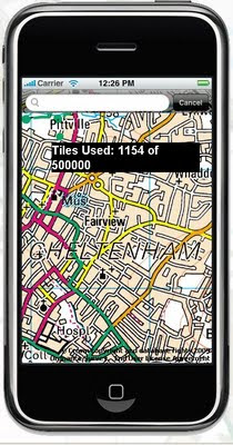
What is looks like on screen? (minus the tile number)

Free OS Maps iPhone
This service is not the fastest, but does work well, though you will find high data transfers costs using this service. But the idea is right, if caching of data is allowed on the phone in theory the user can 'cache os maps' before they venture out with the device.

iOSMap uses the new the mapping data provided by the OpenSpace API from Ordnance Survey, to show feature rich geographic, geotopic and cartalogic data of Great Britain. The application make use of OpenLayers, gmaps and prototype libraries and was written using the mighty iPhone sdk in Objective-C 2.0 and C.

Geeky info:
client:
iPhone/iPod Touch.

OpenLayers:Map,Control,GridProjection
OpenSpace 0.72:Map, Gazetter, GridProjection
Prototype1.6:prototype.js, scriptalicios.js
Google:gMapsAjaxSearch, googlemaps (check terms of use using google maps api and openspace api together?)

But very promising and will be the future of mapping, though not sure it will replace paper/book maps as they never run out of batteries...
Mapperz

To get the free OS Maps App on the iPhone website is:
http://www.publicfootpaths.com/

Labels: , , , , , , ,

22 June 2009

iPhone MobileNavigator [NAVIGON]

iPhone MobileNavigator [NAVIGON]

Navigon iPhone GPS Navigator
Now Available via iTunes Apps

"Turn your iPhone into a first-rate navigation system with MobileNavigator. Try the feature for yourself and enjoy the excellent user control and superior design that allow simple and intuitive operating. The application includes the latest map material from the market leader NAVTEQ and can be used without an Internet connection, which is of enormous benefit abroad, for example, as no extra charges are incurred. With MobileNavigator you can turn your iPhone into an equally handy and convenient route guidance system."

Features and range of functions:

  • 2D and 3D map displays
  • Can be used in portrait and landscape format
  • Precise voice announcements
  • Intelligent address entry
  • Reality View Pro (realistic display of motorway interchanges and exits)
  • Lane Assistant Pro
  • Real signpost display
  • Speed Assistant with adjustable audio-visual warning
  • Day and night mode for map display
  • Direct access and navigation to contacts saved in the iPhone's address book
  • The latest NAVTEQ map material including more than two million (EU version) places of interest (POIs)
  • Navigation is automatically resumed after an incoming phone call
  • Quick access to user-defined POIs in the area and along the route
  • Take Me Home function with a single click
  • Automatic language selection to match the iPhone's user language
Cost:
Navigon’s MobileNavigator Europe app (iTunes link) is now listed on the App Store for a one-time price of $94.99 [£58] but a note in the description claims that the “special introduction price is valid only until June 30th.”

Similar Products for Windows/PDA's

also S60 3rd Edition Phones

Source:
http://blogs.zdnet.com/Apple/?p=4220

Labels: , , , , ,

08 June 2009

Scoot Maps and Filters

Scoot Maps and Filters

Scoot Maps
Find many things fast using the scoot database and overlay it on google maps

http://tinyurl.com/scoot-maps

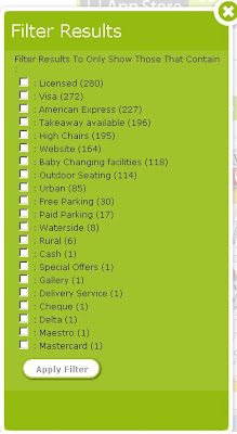
The unique feature here is in the filter options: Even the option to filter by payment.

Scoot Maps Filter

iPhone users will be happy to know there is a Free iphone app created by scoot.
http://www.scoot.co.uk/about-us/scoot-iphone-app.html
(maps and directions available) hopefully more mobile devices will be available in the near future.

Labels: , , , , , ,

14 May 2009

OffMaps - OpenStreetMap - iPhone

OffMaps - OpenStreetMap - iPhone

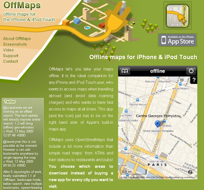
Offmaps OpenStreetMap on the iPhone

OffMaps allows you to access maps and location bookmarks wherever you are, even offline and abroad. This stores maps directly on your device for any area and zoom level you request. This gives you true offline maps for any region and city.

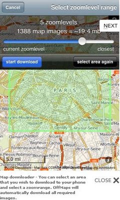
Offmaps OpenStreetMap on the iPhoneOffmaps OSM iPhone downloader
Image Sources: http://offmap.net/screenshots-offline-maps-appstore.htm

OffMaps does not come with one limited set of maps preloaded: It lets you download as many maps as you like for any area at no additional cost.

OffMaps has two modes: online and offline mode.

Online mode you can pan and zoom normally through the world map. Map images that have not been cached will automatically be loaded and saved to the cache for later offline use.
You can also search for locations around the world, add bookmarks and preload whole areas in a zoom range of your liking. Of course you can view your own location too.

Offline mode you can only view maps of areas that you have previously seen or preloaded. You can view your current location and bookmarks, but can't use the search as this requires the large CloudMade database that is only available online. You can even add local bookmarks by tapping the map at any location.

Features
OpenStreetMap Maps (Online Community Created Maps)
Maps with cache and download function
Online Search for places, cities and features
Bookmarks (offline and online) with internal search
Display of own current location with accuracy indicator
Map scale in kilometres or miles
Data roaming disabled (default), OffMaps will automatically go to offline mode when abroad.

For an Online Video of the map application see http://offmap.net/video-offline-maps-iphone.htm

Map source to see the level of detail:
http://maps.cloudmade.com

Source:
http://community.cloudmade.com/blog/2009/05/13/cloudmade-is-powering-the-1-and-3-iphone-apps-in-the-uk/


Labels: , , , ,

27 December 2007

iPhone GPS

iPhone with GPS

  • better fix
  • better accuracy
iPhone LOCO GPS
iPhone with GPS Module


iPhone LOCO GPS dimensions
Loco GPS

Images courtesy of
http://partfoundry.com

More Information:
http://partfoundry.com/iphonegps.html


The GPS module will work on both the iPhone as well as the iPod touch

price
$89
£44.98

Labels: , , , ,

01 July 2007

iPhone or N95?

Okay in simple terms why Mapperz bought an N95 and not an iPhone.

The iPhone has:
  • Touch Screen (3.5-inch (diagonal) widescreen multi-touch display))
  • Auto rotate
  • Maps (Google)
  • Quad Band (850, 900, 1800, 1900 MHz)
  • Wifi -Wi-Fi (802.11b/g) no n?
  • 2 Mega-pixel camera (my 5 year old camera has 3mega-pixel)
  • Limited Software available
  • A Polishing Cloth.
iPhone with Map no GPS!
Image:geothought.blogspot.com

Though it lacks one fundamental feature. GPS

If your going to have mapping on your phone, you want to know where you are, not Steve Jobs Office Location.

Just this one missing feature stops Mapperz pursuing the iPhone.

Location based information is useless unless it is providing information around your position or desired destination.

Now if Nokia and Apple produced a product together then it would be a better solution. But this is unlikely.

The N95 has done and is still doing it's job, however the information that phone has in its needs to be updated and cleaned. It is only a computer and can only give you the information it has.
(more map updates from TeleAtlas needed)

N95 has
  • GPS - Locates you in a few seconds (faster in the car with 12v of power)
  • Built in Maps - if you pre-load onto your memory card.
  • Built in Sat Nav with voice commands (if purchased)
  • 5 Mega-pixel camera.
  • Lots of supported software available.
N95 Maps GPS Active
Image:Allaboutsymbian.com

Mapperz own views, comment if you like.

Labels: , , , ,

11 January 2007

iPhone Maps

Update on the Device Name.
Apple seem to have forgotten an internet search on 'iPhone'
hence CISCO Systems are suing them for using their trademark name.

New names for Apple (for Free)
"Wireless Dog and Bone" (Cockney (East London) slang for Phone)
"ILMTCMD" (Internet lightweight multi-touch communications mobile device)
iTelephone is also CISCO

but PhonePod more likely

The CISCO iPhone (yes little "i")


Like creating a search engine or map search and calling Google 2.0/Google Maps 2.0
(no not intending to Google Inc)

More on this from BBC News

iPhone works with Google Maps see here (quicktime required)

iPhone with Google Maps

"With Google Maps and iPhone’s amazing Maps application, you can view maps and satellite images, or get directions and traffic information, all from iPhone’s remarkable, easy-to-use touch interface."


But wheres the GPS? to tell you, your not lost.

Might look pretty but who has used one?

Nokia might have the edge with the N95 (has GPS integrated)

One question for both products. Battery Life?

Update with Phone Specifications (Official)
iPhone Spec
N95 Spec

Remember at the end of the day it is your choice

Mapperz

Labels: , , , , ,