->

12 February 2010

Google Maps Gets Beta Labs

Google Maps Gets Beta Labs
*Google Account signin required
Google Map has now enabled Google Labs experiments that you can now add some nice and useful functionality.
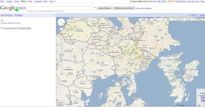
Google Maps Labs Rotated
A new prespective - Note the Map Labels (Text) are correct way up but the map is upsidedown.
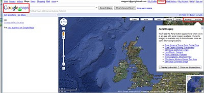

Google Maps Labs New
New Features and Tools in Google Maps via Google Maps Labs - Rotate Map Types (Sat

Google Labs experiments that you can now add the following functionality:

Drag 'n' Zoom
Zooming in on a specific part of the map is now fast and easy. Simply click the Drag 'n' Zoom button, draw a box on the map.
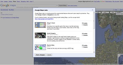
Google Maps Labs

Google Maps Labs Drag Zoom
New Button for Drag Zoom - Useful!

Click on the Green beaker New! to access the new features (simliar to gmail labs)

The Options are as follows
Aerial Imagery (Includes Rotate)
Add Aerial imagery to the map! Aerial imagery gives you rotatable, high-resolution overhead imagery presented in a new perspective. Currently imagery is only available in certain areas, but we're adding more all the time.

Back to Beta
Gmail isn't the only one that can enjoy a BETA tag.

Where in the World Game
Test your knowledge of world geography. Guess the name of the country from satellite imagery, and try to beat your top score.

Rotatable Maps
Tired of North always being up? Add rotatable map types and give East, West and South a fair go.

What's Around Here?
Adds a second search button that searches for "*", returning the top results in the current view. A great way to browse the map.

LatLng Tooltip
Displays a tooltip next to the mouse cursor showing the latlng directly underneath it.

LatLng Marker
Adds an option to the context menu that lets you drop a mini marker showing the latlng of the position that the cursor was pointing at when the context menu was evoked.

Smart Zoom
Ever zoom in too far and get the message "We don't have imagery at this zoom level"? Ensure you don't see it again, with Smart Zoom, which will check in advance what imagery exists, and ensure you can't zoom in beyond it.

source:
http://blogoscoped.com/archive/2010-02-12-n86.html
Related
http://googlemapsmania.blogspot.com/2010/02/google-maps-in-google-labs.html
Official Post
http://google-latlong.blogspot.com/2010/02/introducing-google-maps-labs-your.html

Labels: , , , , , ,

03 March 2009

CloudMade Map Editor

CloudMade Map Editor

update 05/03/2009
CloudMade feedback (see comments) looks promising. Thanks for the kind remarks, always willing to help a brilliant minded concept.

Ever wished you can create your own style of map online?
Well CloudMade Map Style Editor might be what you have been waiting for.

"Tired of the same old maps? CloudMade's Style Editor lets you create customized cartography that you can use to distinguish your applications. With the Style Editor, you can easily create a unique map style in a matter of minutes without having to install any special software or have any previous cartography experience"
source:Cloudmade

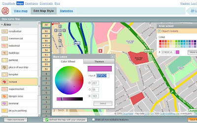
It uses data from Open Street Map, then allows a logged in user to edit the colour of Roads, Points of Interest [POI], Area features.
Cloudmade Editor School colour picker
Selecting and editing colours is made easy using this CloudMade Map Style editor.

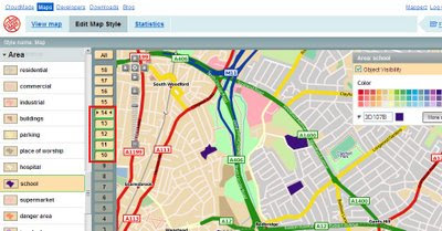
But what happens if you want different representations of a feature at different scales?
Cloudmade Editor School colour picker - Zoom Levels
Note the zoom scales selected, at these scale you will see a strong purple representation, zoom in and it will be transformed into a more subtle colour (this is only for demonstrating this technique).

Mapperz wish list: (now this is just a very short version)
  • Edit Fonts (Annotation) but notoriously difficult to implement
  • Text Placement, Centre, North,South,East,West placement of point/symbols with text.
  • CMYK colour picker option (for printer), RGB and Hexidemical colours only useful for Screen/Web. See ColorBrewer for this type of usefulness.
  • Polygon to Point Representation [e.g.When a School is at an unsuitable scale for area representation is can be displayed by a point/symbol instead)
  • Preview/Outline Mode (with Auto Refresh) - currently the user requires to click 'refresh the map with your changes' button. Outline mode for seeing the nodes and segments. Similar function is in Adobe Illustrator.
  • Reorder Layers, ranking structure - sometimes having polygons above features can be useful, like a masking out polygon.
  • Export File like Illustrator. (maintaining styles and line widths with attributes).
  • Grid or Graticule Option.
  • Fix the Help [http://www.cloudmade.com/site/products%2Fstyle-editor%2Fhowto] The requested URL /site/products/style-editor/howto was not found on this server.
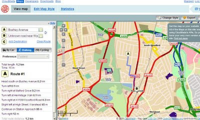
CloudMade Custom Map Directions
And finally you can already add routing/directions to you customised map, this is because the underlining data has not been changed. Only the graphical representation of the data has been customised.

This is just one of many products CloudMade is offering - here is a full list of all.
http://cloudmade.com/products


Some have already created their own map styles, this are available to view
http://cloudmade.com/products/style-editor/gallery


Below is Mapperz first attempt at showing the schools changing colours when zooming in.


Labels: , , , , , ,

01 July 2007

iPhone or N95?

Okay in simple terms why Mapperz bought an N95 and not an iPhone.

The iPhone has:
  • Touch Screen (3.5-inch (diagonal) widescreen multi-touch display))
  • Auto rotate
  • Maps (Google)
  • Quad Band (850, 900, 1800, 1900 MHz)
  • Wifi -Wi-Fi (802.11b/g) no n?
  • 2 Mega-pixel camera (my 5 year old camera has 3mega-pixel)
  • Limited Software available
  • A Polishing Cloth.
iPhone with Map no GPS!
Image:geothought.blogspot.com

Though it lacks one fundamental feature. GPS

If your going to have mapping on your phone, you want to know where you are, not Steve Jobs Office Location.

Just this one missing feature stops Mapperz pursuing the iPhone.

Location based information is useless unless it is providing information around your position or desired destination.

Now if Nokia and Apple produced a product together then it would be a better solution. But this is unlikely.

The N95 has done and is still doing it's job, however the information that phone has in its needs to be updated and cleaned. It is only a computer and can only give you the information it has.
(more map updates from TeleAtlas needed)

N95 has
  • GPS - Locates you in a few seconds (faster in the car with 12v of power)
  • Built in Maps - if you pre-load onto your memory card.
  • Built in Sat Nav with voice commands (if purchased)
  • 5 Mega-pixel camera.
  • Lots of supported software available.
N95 Maps GPS Active
Image:Allaboutsymbian.com

Mapperz own views, comment if you like.

Labels: , , , ,

07 June 2007

MapInfo Professional 9.0 - Released

MapInfo Professional 9.0 - Released

MapInfo Professional 9.0


Top New Features are:

  • Save Window as GeoTiff (Georeferenced ScreenShot)

  • Direct Access to ESRI Geodatabases (File and Personal GDB), DWG,DXF and DGN files.

  • On-the-fly Indexing (Geocoding TAB files and Remote Tables)

  • Curved Text Placement (Wow! about time)

  • Time Based Analysis of Data - Change over time.

  • Supports Windows Vista (Ultimate only)

More Info and PDF's

Source: http://slashgeo.org/

http://technology.slashgeo.org/technology/07/06/07/1345221.shtml


Mapperz

Labels: , , , ,

01 April 2007

Nokia N95 - part 1, The Navigator (Smart2go)

Nokia N95 - part 1, The Navigator (Smart2go)

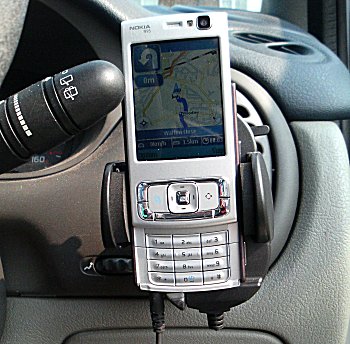
N95 in Action in Car
Image source: allaboutsymbian

A first clear and detailed review of the N95 (super duper smart phone) and the Smart2go mapping application.
Officially Released Tomorrow (2nd April 2007) in the UK.

in summary the review points out:
the pluses +
  • maps are basically completely free
  • option to have all maps stored on your expansion card or to grab them as needed over GPRS or 3G (cheaper to get them via wifi)
  • Navigation always intuitive
  • Route planning was as good as any other
  • 2D and 3D view Mapping (like a TomTom)
  • The zoom/scale is adjusted dynamically
minuses -
  • Navigation is not free (approx £30 (€50)) per year for turn by turn info
  • tediously slow, nokia maploader servers are slow due to high demand (leave overnight to download)
  • Battery life in GPS mode is approximately 1 hour from a full charge (best used with 12v car charger for navigation)
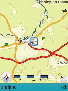
N95 in Action Reading Map
Image source: allaboutsymbian

Overall this combination of an all in one smart device and mapping is the start of bring all the 'now' technologies (gps,wifi,3g etc) together to make a very useful and handy for everyday life.

read in more detail at http://www.allaboutsymbian.com/reviews/item/Nokia
_N95-part_2_the_Navigator.php

Labels: , , , , , , ,

08 January 2007

Golf Course Finding Map

Golf Course Finding Map

Golf Course Finding Map

But with some clever integration
  • Search 10,20 or 50 Mile Radiuses
  • Dynamic Pan (Auto updates finding new courses in the radius range)
  • Dynamic Overview Pan as above but the overview map syncronized with the main map
  • Interactive Sidebar
  • Hotels Listed
Very fast retrieval of Markers and a well thought out map.
Well done The Golf-Finder.net Team

Full instructions on use

Labels: , , ,

19 December 2006

Google Maps 2007....

A post for all to post requests on what users would like to see in Google Maps 2007.

continuation from http://googlemapsbook.com/

(Possible) New Features include:

UK Geocoding (even if that means buying Ordnance Survey and Royal Mail!)
Directions but including with Air and Sea (distance/time).
Power Find - not only finds nearest but suggests based on search.
Load from local machine or Google Spreadsheets (fields with lon/lat in)
Gmail Mapping contacts addresses - with quickest route plus via.

Possible New Layers
4 D Time (Temporal) Mapping (example, London over time 4th Century to Present 2007)
Underground mapping?
Sea Bed (bathymetry) mapping layer.
Population density/migration

post a suggestion - your chance to speak to google maps!
(they have been known to read this blog now and then.)

mapperz

Labels: , , , ,

07 November 2006

Live Local - 3D London bits

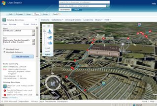
3D London Local Live with Driving Directions
Live Local in 3D in London with driving directions.

The good bits:
Free, 3D Views with tilt (Ctrl+left mouse click)
Aerial Photography (orthorectified) is better than other app (google earth/maps, world wind, skyline globe etc)

The poor bits
It does not work in FireFox.
But is a bit clunky on a 2MB broadband connection (yes the hardware is accelerated to max).
Why the user needs to install plugins (that failed). Used VirtualEarth3D.msi to solve the problem.

Tips Navigate 3D maps with the mouse or keyboard
Pan the map

Choose any of the following options:

* Click one of the four directional arrows in the compass to pan the map in that direction.
* Click a point on the map, and then drag the map in any direction.
* Use the arrow keys.
Pivot the map

Choose any of the following options:

* Click on the ring of the compass, and then drag the ring in any direction.
* Press the CTRL key while you drag the map to the left or to the right.
* Press the CTRL key, and then press either the left or right arrow key.
Turn the map view

Choose any of the following options:

* Press the SHIFT key while you drag the map to the left or to the right.
* Press the SHIFT key, and then press either the left or right arrow key.
Tilt the map

Choose any of the following options:

* Drag the small slider inside the ring of the compass.
* Press the CTRL key while you drag the map up or down.
* Press the CTRL key, and then press either the up or down arrow key.
Change your pitch

Choose any of the following options:

* Press the SHIFT key while you drag the map forward or backward.
* Press the SHIFT key, and then press either the up or down arrow key.
Change your altitude

Choose any of the following options:

* Press the SHIFT key while you rotate the mouse wheel.
* Press the page up or page down key.

Zoom in or out on the map

Choose any of the following options:

* Rotate the mouse wheel forward or back.
* Press the CTRL key and rotate the mouse wheel forward or back to zoom toward or away from the pointer.
*
Press the hyphen (-) or the equal (=) key on the keyboard.

Labels: , , ,

Virtual Earth 3D Launches

Official News Blog

Local Live updated - Virtual Earth Version 4

Virtual Earth 3DVirtual Earth 3D

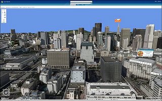
Microsoft uses aerial cameras that take photos of cities and render the images into Microsoft's Virtual Earth 3D, announced on Monday, allows advertisers to buy banner ads that float above buildings in photorealistic environments. The application, which downloads into a browser, melds together Virtual Earth's 3D features and Microsoft map and local search. In this screen shot, Zip Realty ads appear on virtual billboards

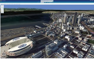
3D graphics for the new Virtual Earth 3D application, which downloads into a browser. The rendering creates photorealistic scenes featuring buildings, roadways and bodies of water.

Microsoft's Virtual Earth 3D melds together photorealistic cityscapes with its existing online mapping services, such as traffic reports shows color-coded freeways in Los Angeles indicating which roadways are congested and which are clear.

Microsoft's new Virtual Earth 3D online mapping interface allows people to "fly" through cities much as they would in virtual reality scenes and online games, with graphics that are as realistically rendered.

Three-dimensional models are available initially for 15 U.S. cities: San Francisco, San Jose, Seattle, Boston, Philadelphia, Los Angeles, Las Vegas, Detroit, Phoenix, Houston, Baltimore, Atlanta, Denver, Dallas and Fort Worth. Terrain imagery in 3-D is available globally, and Microsoft expects to offer 3-D imagery in an ever expanding set of cities. Other features provided by Live Search include access to real-time traffic information in select major U.S. cities, and access to business listings "yellow pages" and people listings "white pages" that allows consumers to easily find local information and act on it.

Update:
IE6 & IE7 only
to view 3D you need this plugin (but who wants to install another plugin?)
Mircosoft Servers are having serious issues at the moment (surprise, surprise).
Looks good when works!
Mapperz

Labels: , ,

02 November 2006

New Features in Google Earth 4 Beta

New Features in Google Earth 4 Beta (4.0.2416+)

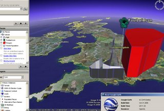
Google Earth 4 Point Line Polygon

Now Supports:
Drawing of paths and polygons (was only available in Google Earth Plus)
Point Lines and Polygons can be Extruded with elevation or made floating in space.
New Icons for Placemarkers
Faster 3D model rendering
Improved lighting for models
Print of driving directions

More info
Google Earth Blog

Download Google Earth 4 beta (Free)

Official update

Labels: , , , ,