->

08 April 2010

OSM edits with OS Streetview 10k Rasters

OSM edits with OS Streetview 10k Rasters (GB only)

This layer is now in the main OSM editor (Potlatch) on http://www.openstreetmap.org
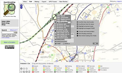
switching to 1:10,000 UK:Streetview Raster Background in Open Street Map Editor

Before you go to far please read this
http://wiki.openstreetmap.org/wiki/Ordnance_Survey_Opendata

take note of:

When tracing over OS StreetView

  • When everything is derived from OS StreetView source=OS_OpenData_StreetView
  • When just the name is derived from OS StreetView source:name=OS_OpenData_StreetView

When adding OS vector data

Choose an appropriate tag for the object based upon the OS OpenData product. For example source=OS_OpenData_Boundary-Line
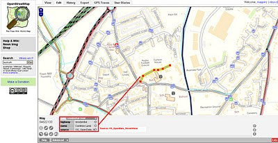
OS OpenData StreetView OSM editor Potlatch
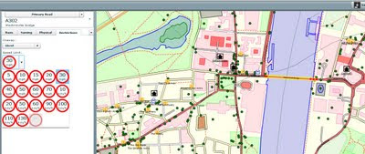
OSM edits with OS StreetView 10k Rasters - adding a Residential Road.
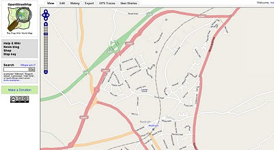
OS OpenData StreetView OSM Potlatch Redruth
http://www.openstreetmap.org/?lat=50.23952&lon=-5.22222&zoom=15&layers=B000FTF

Redruth, Cornwall has always been a bit thin on the ground with OSM data but the Ordnance Survey Open Data Rasters (re-projected)to WGS84 can now help as a background to trace. If tracing from OS Rasters please use the tag source=OS_OpenData_StreetView (if both Name and Road have be derived from OS opendata)
if just the name source:name=OS_OpenData_StreetView

source & thanks to: http://twitter.com/richardf/statuses/11754544110
OS StreetView is now in #osm potlatch editor at zoom levels 15/16 - just click the options icon and select 'OS StreetView'

Labels: , , , , ,

30 November 2009

OpenSteetMap Potlatch 2 Development Preview

OpenSteetMap Potlatch 2 Development Preview
"It's not just an online map editor - it's a Live Cartographic Online Editor"
Potlach 2 Editor

OpenStreetMap users are getting a brand new online 'cartographic' editor in the form of Potlatch TWO (2.0)
Potlatch 2 is a complete rewrite.

Aim:

  • Speed

  • Ease-of-use

  • Flexibility

Four big new features :

1.New feature – friendly tagging system Potlatch 2 has a friendly, intuitive tagging system. The mapper can use graphical menus, dedicated fields, and icons to get the tagging just right – without the need to remember tag names and values.

Graphical Presets - no need to lookup or remember tags

Potlach 2 has a friendly, intuitive tagging system. The mapper can use graphical menus, dedicated fields, and icons to get the tagging just right – without the need to remember tag names and values.

2.New feature – 'What You See Is What You Get' (WYSIWYG) rendering Potlatch 2 has an all-new rendering engine far in advance of the current one.


Potlach 2 Editor MapCSS


source:http://www.opengeodata.org/2009/11/30/introducing-a-new-osm-editor-potlatch-2/
With road names, patterned fills, rotated icons, and much more,form a Cartographic editing experience can be like working live on the familiar Mapnik rendering, the cyclemap, Osmarender, or anything you like -making it much more approachable for the beginner.Thumbs ups for this!

3.Cascading Style Sheets - CSS but for Maps = MapCSS


Just like the tagging, the rendering is easy to customise. It uses a special form of CSS, called MapCSS, which lets you create wonderful-looking maps with just a few lines of text. The tagging and rendering together make Potlatch 2 ideal for ‘vertical’ mapping applications, such as a cycle-specific editor or a building/addressing editor. Stylesheets aren’t just about making the map look pretty: you can create stylesheets to help your mapping, such as one that highlights roads without names.
So if your only interested in Footpaths then only show footpaths


Because this integrates fully with MapCSS stylesheets, you can choose to temporarily hide background data, or show (say) only footpaths… whatever you like.

So Potlatch 2 will have an accompanying ‘OSM Guide’, explaining the basics with friendly, illustrated text. It will be concise, focused and clear.

4.New feature – vector background layer Mappers are working more and more with imports. But the approach until now has been to import data directly into the map – and many people have pointed out the problems this can lead to.Highly requested


Potlatch 2 will support vector background layers.

You can load OSM-formatted data from servers or files, and work on bringing it into the map the way you want, at your own pace.
Fully rewritten in ActionScript 3 Potlatch 2 is written in ActionScript 3, a Java-like language with an open source compiler and full docs available online. The Potlatch 2 source comes with instructions on getting started and is, of course, permissively licensed under the WTFPL.
Potlatch 2 thus far has been written by Dave Stubbs and Richard Fairhurst (Great Work). But we would love to see more people hacking on the source. There’s a potlatch-dev mailing list especially for this.

New Existing Features likely to be coming:
Some other features, like Yahoo and tiled backgrounds, are finished but not currently exposed through the editor: they’ll be along shortly. Others, such as GPS track support, the Beginners’ Guide and the vector background layer are not coded yet but are intended for the initial release.Load Import Shapefile? Export Shapefile options?? Would be good. [Hint]


Potlatch 1 has some three years of development behind it, of course, and much of this feature set has not yet been ported to Potlatch 2. There’ll be countless little UI tweaks (no keyboard shortcuts yet, for example!); and as you’d expect for an in-development version, performance can sometimes be sluggish and there’s a lot of optimisations we’d like to do.
But with work progressing so fast, this seemed a great time to talk about it. Both the tagging system and the renderer are enormously flexible and we’d like to see people hacking on them as soon as possible.
Live Version
at:http://www.geowiki.com/potlatch2/
Renderer alone at:
http://www.geowiki.com/halcyon/

Should you want to try a particular area, just put the lat and lon in the URL like this:


http://www.geowiki.com/potlatch2/?lat=52.2&lon=0.1http://www.geowiki.com/halcyon/?lat=52.2&lon=0.1

Source Code is at:http://trac.openstreetmap.org/browser/applications/editors/potlatch2

More on MapCSS and documentation at:http://wiki.openstreetmap.org/wiki/MapCSS

Full Credit and Original Post
http://www.opengeodata.org/2009/11/30/introducing-a-new-osm-editor-potlatch-2/

Labels: , , , , , , ,

17 August 2009

Easy OpenStreetMap Editors

Easy OpenStreetMap Editors


One early frustration with wanting to help the OpenStreetMap project was how do you edit the data easily?

OpenStreetMap has lot and lots of data already, though more and more people are required for their local knowledge and to do the mamouth task of keeping the 'map up-to-date'

Well there are lots of different applications from online editors to compiled source code are out there. Which is easiest and user friendly?

These two are mapperz best picks

Merkataartor (v0.14) - fairy new software - but nicely laid out user friendly. Has great potential and is supported by most OS
see the list
http://wiki.openstreetmap.org/index.php/Merkaartor#Download
http://www.merkaartor.org/Download/

Small download, very simple to use - download by area/map of your choice.
No knowledge of OSM to start using. (But advise you to research first)
uploading does require a osm account so you can contribute but downloading and viewing data (in cartographic map-form) does not require a login.
Merkaator Yahoo Imagery - London Bridge

Software is updated regularly and many features have been added - recently Area digitising and tagging tools have been introduced.
Offline mode.
Map Style mode - set one from the list or make your own.
Documentaton: http://wiki.openstreetmap.org/index.php/Merkaartor_doc_0.12
(requires an update to v0.14)


Potlatch - long standing Open Street Map 'online editor' but now more user friendly than ever (thankfully).
Back along mapperz liked the idea of editing in a browser (as all GIS will be in the future).
But Potlatch back then was slow,buggy and choked the browser up - all those issues are long gone and now it is a really fast and easy way to edit 'live'.

Potlatch POI drag and drop editing
Potlatch has greatly increased productivity due to the 'drag and drop' POI (Points of Interest) tool. Tip you reuse tag names with the 'r' button (repeat tag) remember to give as much infomation as you know.
Note: There are many tag names (too many to list) please visit
http://wiki.openstreetmap.org/wiki/Map_Features
for a full list of tags.

Yes, there are many, many other OSM editors out there but this is for the curious potential new user, that just wants to help out.

others:
JOSM is currently the most popular desktop editor. It is a standalone Java application (requires Java 1.5) which allows fluid zooming, panning, and editing of a locally stored dataset, before uploading changes in a batch.

OSM2Go is a mobile mapping solution currently supporting the Nokia Internet Tablet family (N800 & N810), can also be compiled for the Linux/GTK+ desktop.

Vespucci [1] for android devices.

Amenity Editor is a simple online editor for creating and editing nodes and POIs. (ATM only in German)
source:
http://wiki.openstreetmap.org/wiki/Editing

Labels: , , , , , , ,

29 May 2009

Up2Maps Thematic Maps Editor

Up2Maps Thematic Maps Editor

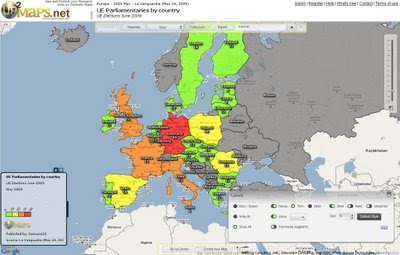
Up2Maps Europe - using Google Maps Flash API
Create Thematic Maps Fast with Up2Maps

Feature List
:
  • Maps can be exported to image (png) or embedded in blogs.
  • Data can be uploaded in excel files or typed directly in the application.
  • There are 2 levels of detail for each country.
  • Runs on Google Maps Flash API
  • Data includes territory names, zip/postal codes and international codification like FIPS and ISO.
Up2Maps Europe Editor
Map Editor - Build your own Thematic Map - Maps can be edited in many ways (colors, labels, legend etc)

Thanks to Moisés García
http://www.up2maps.net/

Ready Made Map EU Parliamentaries by Country
http://www.up2maps.net/maps/Gamusin23/Europe/ue_parliamentaries_by_country.html

Labels: , , , ,

03 March 2009

CloudMade Map Editor

CloudMade Map Editor

update 05/03/2009
CloudMade feedback (see comments) looks promising. Thanks for the kind remarks, always willing to help a brilliant minded concept.

Ever wished you can create your own style of map online?
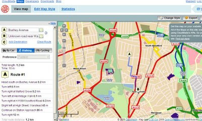
Well CloudMade Map Style Editor might be what you have been waiting for.

"Tired of the same old maps? CloudMade's Style Editor lets you create customized cartography that you can use to distinguish your applications. With the Style Editor, you can easily create a unique map style in a matter of minutes without having to install any special software or have any previous cartography experience"
source:Cloudmade

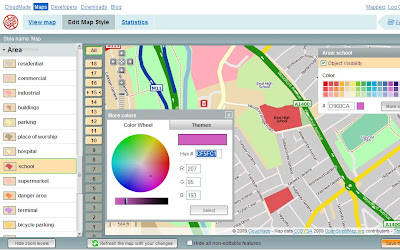
It uses data from Open Street Map, then allows a logged in user to edit the colour of Roads, Points of Interest [POI], Area features.
Cloudmade Editor School colour picker
Selecting and editing colours is made easy using this CloudMade Map Style editor.

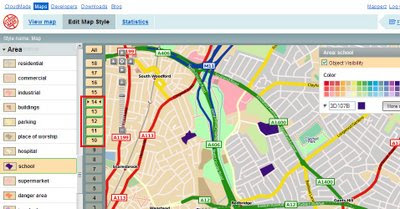
But what happens if you want different representations of a feature at different scales?
Cloudmade Editor School colour picker - Zoom Levels
Note the zoom scales selected, at these scale you will see a strong purple representation, zoom in and it will be transformed into a more subtle colour (this is only for demonstrating this technique).

Mapperz wish list: (now this is just a very short version)
  • Edit Fonts (Annotation) but notoriously difficult to implement
  • Text Placement, Centre, North,South,East,West placement of point/symbols with text.
  • CMYK colour picker option (for printer), RGB and Hexidemical colours only useful for Screen/Web. See ColorBrewer for this type of usefulness.
  • Polygon to Point Representation [e.g.When a School is at an unsuitable scale for area representation is can be displayed by a point/symbol instead)
  • Preview/Outline Mode (with Auto Refresh) - currently the user requires to click 'refresh the map with your changes' button. Outline mode for seeing the nodes and segments. Similar function is in Adobe Illustrator.
  • Reorder Layers, ranking structure - sometimes having polygons above features can be useful, like a masking out polygon.
  • Export File like Illustrator. (maintaining styles and line widths with attributes).
  • Grid or Graticule Option.
  • Fix the Help [http://www.cloudmade.com/site/products%2Fstyle-editor%2Fhowto] The requested URL /site/products/style-editor/howto was not found on this server.
CloudMade Custom Map Directions
And finally you can already add routing/directions to you customised map, this is because the underlining data has not been changed. Only the graphical representation of the data has been customised.

This is just one of many products CloudMade is offering - here is a full list of all.
http://cloudmade.com/products


Some have already created their own map styles, this are available to view
http://cloudmade.com/products/style-editor/gallery


Below is Mapperz first attempt at showing the schools changing colours when zooming in.


Labels: , , , , , ,

09 August 2008

Sliverlight Map - Editor with Exporter

Sliverlight Map - Editor with Exporter

IDV Solutions Sliverlight with SQL & KML Output Map
Idvsolutions.com have produced a neat Virtual Earth based mapping editor that allows a user to create point,line and polygon overlays, all three have attributes attached and can be exported to KML (Google Earth) or SQL Server 2008 formats.

SQL 2008 output for the Features above:

CREATE TABLE VisualFusionShapes (fid int IDENTITY (1,1), title nvarchar(120), description nvarchar(500), geo geometry);
INSERT INTO VisualFusionShapes (title, description, geo) VALUES ('Georgia', '', geometry::STGeomFromText('POLYGON((39.919084 43.463258,40.358537 43.622528,41.017717 43.542946,41.347306 43.399432,41.632951 43.303566,42.138322 43.287574,42.445939 43.287574,42.731584 43.207550,43.434709 42.918592,43.632463 42.757471,43.720353
42.595930,44.225724 42.725196,44.511369 42.805851,44.972795 42.805851,45.456193 42.628272,45.719865 42.482602,45.697892 42.125089,46.269181 41.978249,46.510881 41.880166,46.269181 41.732761,46.379045 41.486331,46.620744 41.436932,46.686662 41.288510,46.488908 41.156295,46.313127 41.238960,45.631974 41.354517,45.236467 41.371008,44.621232 41.222436,44.159806 41.222436,43.764299 41.172836,43.368791 41.172836,42.995256 41.420457,42.819474 41.585016,42.599748 41.634302,42.511857 41.535692,42.094377 41.535692,41.567033 41.535692,41.742814 41.798316,41.654924 42.157674,41.545060 42.466395,41.457170 42.660597,41.281388 42.773602,41.017717 42.821970,40.973771 43.031126,40.446427 43.239572,39.919084 43.463258))', 0));
INSERT INTO VisualFusionShapes (title, description, geo) VALUES ('Area of Interest', '', geometry::STGeomFromText('LINESTRING(37.414201 46.606405,50.422013 46.636587,50.465959 39.827914,37.502092 39.811038,37.414201 46.591307)', 0));
INSERT INTO VisualFusionShapes (title, description, geo) VALUES ('Icon', '', geometry::STGeomFromText('POINT(317.461308 186.55787)', 0));

Loads straight into SQL 2008 Server.

Required is Sliverlight 2
Google Earth or SQL Server 2008 to import the exported files


Bug? Not Sure if this is a bug but when a polygon is created and then the user wants to place a point on top the polygon the polygon becomes editable and no point is placed.

Suggestions

Annotation (Text not attached to any specific geometry)
Predefined Shapes (Circle, Rectangle, Triangle geometry)
Clicking on the edges allows the move the shape
Export to other formats GPX,XML etc.


More information is available
http://idvux.spaces.live.com/blog/cns!2EB6AAF6C3AC1EBE!980.entry


IDV Solutions US Demographics Map
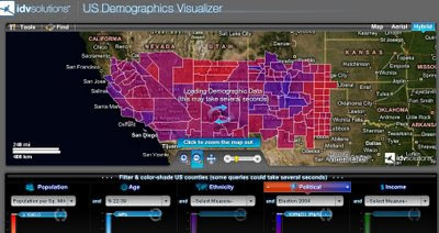
US Demographics Visualizer is also a very good thematic map generator for US Census data.

http://demo.idvsolutions.com/apps/censusdemo/flash/map.html

Labels: , , , , , ,

26 June 2008

Google Map Maker

Google Map Maker

Google Map Maker
Google is now allowing certian areas in the world to be edited by the user


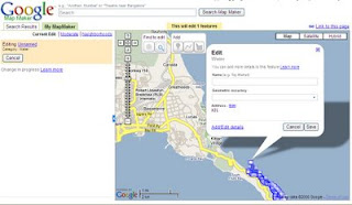
"Google Map Maker is a Google Maps service that allows you add or edit features, such as roads, businesses, parks, schools and more"


Google Map Maker displays in your web browser. The service appears similar to Google Maps, but displays a set of tools that allows you to mark locations and add information. These tools

New Tools allows you to edit content live - but requires a 'google' review before making it to google maps tiles.

Use the Placemark tool to mark a location such as a business or school.
Use the Line tool to mark roads, rivers, etc.
Use the Polygon tool to mark regions, such as a park or neighbourhood. You can enter similar information as with the Placemark tool, but the Polygon tool enables you to mark an entire area.


Scale Dependant for Editing Mode
You need to zoom to a range of 50m to 1km to be able to use Google Map Maker tools. If you use see these tools, try zooming in. To zoom in, use the zoom slider, mouse scroll wheel or right click > Zoom in. To center a point on the map, right click on the appropriate location and choose Center the map.

Metadata (information about the data)

Overview - Basic information about the feature. (name, address, etc.)
Attributes - Specific details about the feature. (road speed, driving direction, photo URL, etc.)
Description - Longer description and comments for reviewers. For example: Comment to moderator - This building has been torn down recently.
Events - Occurrences that pertain to the feature (such a concert that occurs in a park)
History - Record of past edits to the feature (changes made by other users)

Available Locations to be edited (Subject to change)

Antigua and Barbuda
Bahamas
Barbados
Bermuda
British Virgin Islands
Cayman Islands
Cyprus
Grenada
Iceland
Jamaica
Netherlands Antilles
Pakistan
St. Kitts and Nevis
St. Lucia
St. Vincent and the Grenadines
Trinidad and Tobago
Vietnam


Note on Privacy
While you may mark your home on the map by adding the same as a point of interest, Google suggests that you do not reveal such private information in Google Map Maker.
Consider marking it as a Point of Interest

More on this visit
http://googlemapsmania.blogspot.com/2008/06/google-map-maker.html
http://www.google.com/mapmaker/mapfiles/s/support.html
http://google-latlong.blogspot.com/2008/06/making-your-mark-on-world.html#links

Mapperz

Labels: , , , ,

23 November 2006

Google Map Editor - in Alpha (A GIS)

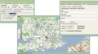
Stefan Blanke has been working on a very sophisticated Google Map Editor

Map Editor in Alpha
The screenshot does not do the 'Editor' justice as there are many editing functions hidden in the tabs.

The Map Editor use a very up-to-date version of the Google Map API (version 2.68 to the coders)
The includes creating Polygon though not implement (maybe version 2.69 needed)
Very Good work though.

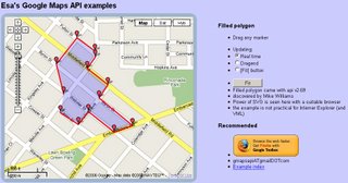
To see editing polygons using that 2.69 version pop over to ESA.
Very good Example of Editing Live on Google Maps.
ESA Edit Polygon Live on a Google Map

So how long before Google Maps becomes 'GOOGLE GIS API'?
At this rate "Early 2007"

Another High End Database (Oracle XE) potential is Oracle XE and Google Maps (though we haven't actually seen the map and data working yet - pre Alpha?)

Labels: , , , , , ,