Sliverlight Map - Editor with Exporter
Sliverlight Map - Editor with Exporter

Idvsolutions.com have produced a neat Virtual Earth based mapping editor that allows a user to create point,line and polygon overlays, all three have attributes attached and can be exported to KML (Google Earth) or SQL Server 2008 formats.
SQL 2008 output for the Features above:
CREATE TABLE VisualFusionShapes (fid int IDENTITY (1,1), title nvarchar(120), description nvarchar(500), geo geometry);
INSERT INTO VisualFusionShapes (title, description, geo) VALUES ('Georgia', '', geometry::STGeomFromText('POLYGON((39.919084 43.463258,40.358537 43.622528,41.017717 43.542946,41.347306 43.399432,41.632951 43.303566,42.138322 43.287574,42.445939 43.287574,42.731584 43.207550,43.434709 42.918592,43.632463 42.757471,43.720353 42.595930,44.225724 42.725196,44.511369 42.805851,44.972795 42.805851,45.456193 42.628272,45.719865 42.482602,45.697892 42.125089,46.269181 41.978249,46.510881 41.880166,46.269181 41.732761,46.379045 41.486331,46.620744 41.436932,46.686662 41.288510,46.488908 41.156295,46.313127 41.238960,45.631974 41.354517,45.236467 41.371008,44.621232 41.222436,44.159806 41.222436,43.764299 41.172836,43.368791 41.172836,42.995256 41.420457,42.819474 41.585016,42.599748 41.634302,42.511857 41.535692,42.094377 41.535692,41.567033 41.535692,41.742814 41.798316,41.654924 42.157674,41.545060 42.466395,41.457170 42.660597,41.281388 42.773602,41.017717 42.821970,40.973771 43.031126,40.446427 43.239572,39.919084 43.463258))', 0));
INSERT INTO VisualFusionShapes (title, description, geo) VALUES ('Area of Interest', '', geometry::STGeomFromText('LINESTRING(37.414201 46.606405,50.422013 46.636587,50.465959 39.827914,37.502092 39.811038,37.414201 46.591307)', 0));
INSERT INTO VisualFusionShapes (title, description, geo) VALUES ('Icon', '', geometry::STGeomFromText('POINT(317.461308 186.55787)', 0));
Loads straight into SQL 2008 Server.
Required is Sliverlight 2
Google Earth or SQL Server 2008 to import the exported files
Bug? Not Sure if this is a bug but when a polygon is created and then the user wants to place a point on top the polygon the polygon becomes editable and no point is placed.
Suggestions
Annotation (Text not attached to any specific geometry)
Predefined Shapes (Circle, Rectangle, Triangle geometry)
Clicking on the edges allows the move the shape
Export to other formats GPX,XML etc.
More information is available
http://idvux.spaces.live.com/blog/cns!2EB6AAF6C3AC1EBE!980.entry

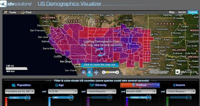
US Demographics Visualizer is also a very good thematic map generator for US Census data.
http://demo.idvsolutions.com/apps/censusdemo/flash/map.html
Labels: 2.0 Mapper, Editor, Export, KML, Silverlight 2, SQL Server 2008, Virtual Earth


1 Comments:
Hey, alright! Thanks for checking out the demo and we're glad you like it! Those are helpful points of feedback. We're having fun refining this tool; check back often for new stuff.
-the IDV team
Post a Comment
<< Home