->

14 January 2010

Edmonton Opens Up City Data

Edmonton Opens Up City Data

The City of Edmonton in Alberta, Canada is following suit of Vancouver and Toronto and opening up city (public) data.

Data available now (more available after review of the community preview Feb 2010).
  • 2009 Census - Age and Gender
  • 2009 Census - Dwelling Unit Ownership
  • Bus Stops Edmonton Transit Locations
  • City Council Meeting Schedule
  • City Parks Locations of various City parks in Edmonton
  • Community League Centres Locations in Edmonton
  • Locations of all Fire stations in Edmonton
  • Locations of historical buildings in Edmonton
  • List of Planned Road Closures throughout the City of Edmonton
  • Police Stations Locations in Edmonton
  • Locations of School buildings in Edmonton

Though Edmonton take it a stage further and provide feeds and data overlay map ready so users can quickly make use of the data.
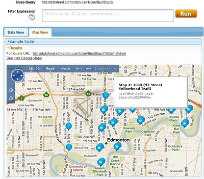
Edmonton Bing map
Default View of Bus Stops Overlay on the Edmonton City of Edmonton Website

Getting to the Data
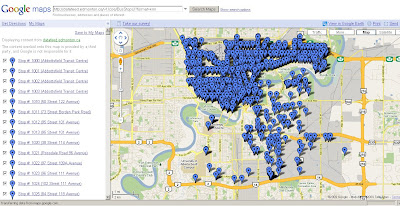
Edmonton KML
This example show the direct feed http://datafeed.edmonton.ca/v1/coe/BusStops/ as a KML (Google Earth) file loaded directly on Google Maps.
To view this Data as above - http://maps.google.com/?q=http://datafeed.edmonton.ca/v1/coe/BusStops/?format=kml

There is a stage futher, not only do City of Edmonton provide Scripts ready made so it makes it much easier for non programmers to create their own web maps.
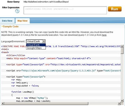
Edmonton bing map source
Default is Bing (Virtual Earth) Maps though drop-down Language Environment reveals Google Maps API source code.
Mapperz edited mashup
This a mapperz example taken from the code above. Though there are two important changes for the examples to work.
1. jquery-1.3.1.min.js needs to be fully mapped to your server/website
2.Google Maps API requires a specific API Key for YOUR site (API Key signup)

Other changes mapperz made are simply moving the latitude and longitude to centre on Edmonton and not Washington DC.

Links - and Well done to the City of Edmonton making this available.
http://data.edmonton.ca/

mapperz version (tweaked to work)
http://mapperz.googlepages.com/edmonton_google_map_source.html

source:
http://www.calgaryherald.com/Edmonton+releases+downloadable+databases/2438135/story.html

Labels: , , , , , , ,

25 August 2009

Open Street Map gets Official Isle of Man Data

Open Street Map gets Official Isle of Man Data

The OpenStreetMap gets a pleasant boost for #OSM Mappers for the Isle of Man.

This is excellent to see. Encouraging for the whole aspect of the project.

Isle of Man 1:25000
OpenStreetMap now has access to Isle of Man Government 1:25,000 data - this contains much detail that can be used to improve the already abundant data in OpenStreetMap.

OSM now has access to two datasets from which can be derived from for the project:
  • the 1:25,000 tourist map (2007) [above], provided as a set of four GeoTIFF images
  • the high resolution aerial imagery (2001) [below], provided as a set of three MrSID images

Isle of Man Aerial Imagery
High Resoultion imagery will help capture detials with out the leg work, and anyone can help contribute to the data capture.

"There is a massive amount of information which we can gain from these datasets still, and I will be posting some ideas soon about different possibilities, such as collecting place names, paths and tracks, historic sites, outlines of the national glens, open rambling land, etc. as well as using the data for error checking and correction in the existing OpenStreetMap dataset.

I am planning to make these datasets available as a WMS server that can be used in JOSM (and Potlatch) for editing, once I've had a chance to organise it, and have had an official license document through."

Dan Karran


Isle of Man Aerial Imagery & 1:25000 overlay

This is a good way to see cartographic features and imagery overlaid - making digital data capture much easier for users.

acknowledgement:

Isle of Man Government map data and aerial imagery © Crown Copyright, DLGE; OpenStreetMap data © OpenStreetMap and contributors, CC-by-SA.

Now would the UK Ordnance Survey allow this? I think not.

source and more information:

http://www.dankarran.com/blog/2009/08/using-official-isle-of-man-map-data-in-openstreetmap

Labels: , , , , , , ,

12 May 2009

Lake District Map - Updated +Heritage Paths Scotland Routes

Lake District Map - Updated + Heritage Paths Scotland Routes

The Lake District Map [3D] has been updated making over 70 different camera views available using a familiar nested link structure. User will find it a good way to explore the different features in the area.

Lake District Map Updated
Fly through tours guide you around the Fells, Lakes, Valleys and Villages of Cumbria, England.

Source: Email from Justin Farrell (Lake District Map Author)


Heritage Paths for Scotland

Another map has just been released from the Heritage Paths covering Scotland
(Heritage Paths Project - ScotWays - Scottish Rights of Way and Access Society)

Heritage Paths Map
View this Map: http://www.heritagepaths.co.uk/map.php?lat=55.85699&long=-2.142191
(use the slider to control transparency of the map tile layers)

This includes some unique features:
  • Roman roads
  • Drove roads
  • Pilgrimage routes
  • Miners’ paths
  • Smuggling routes
  • Trading paths
  • Military roads
  • Turnpike roads
  • Shieling paths
  • Peat-cutting paths
Source:
http://googlemapsmania.blogspot.com/2009/05/taking-high-road-on-google-maps.html

Well done to both for making this data available for all to use.

Labels: , , , , , , ,

12 April 2007

Canada Adopts Free Model for Map Data

Ordnance Survey take note!
Rationale for charging has gone, says government information expert

"If you've got a computer and a fast connection, you can now download all the maps and satellite pictures you could ever want of Canada. Its government has decided to abandon the charging model that it used until last month for the use of its map data and move to a "free data" model - as being urged for Britain by Technology Guardian's Free Our Data campaign"

What about the copyright of the data?

"Another part of the move loosens the ties on the data - although Canada still uses Crown Copyright, it only asks for acknowledgement of the source. We suspect Canada will see the benefits quite soon. Will the UK follow?"
Source: The Guardian - reported by Charles Arthur

Yes Please -sooner rather than in 50 years (when the map data will be out of copyright) by the time they have unwrapped the red tape from the crown copyright issues.
Free our data!

So if you want Canadian Data - and have plenty of free disk space download from these sources

http://www.geobase.ca

http://geogratis.cgdi.gc.ca/geogratis/en/index.html


Labels: , , , , ,