->

13 October 2010

Travellerspoint.com

Travellerspoint.com helps you plot future and past trips on a map. Control trip colours, curves, transport modes.

"The goal of Travellerspoint is to create an international meeting point for travellers worldwide, whether they are planning their travels, currently travelling or have returned from their travels and want to stay in touch with (or find) those travel friends they met while travelling in the past."

TravellersPoint.com Map

http://www.travellerspoint.com/guide/

Labels: , , , , , ,

16 June 2010

Transport for London - Data Released June 2010

Transport for London Data Released June 2010

Transport for London Data Release
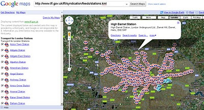
Tube Stations Data (but not up-to-date) in KML format

Data is Available from Here [Feb 2010]
Metadata is Here

Mapped


What is Free?

The London Datastore currently hosts the following travel-related data sets: Via the TfL developer page:

Station Locations

TfL Pier Locations

Live Traffic Cameras

Oyster Ticket Stop Locations

Static files on GLA servers

Cycle Hire Locations

London Underground Signals Passed at Danger

TfL Investment Programme

TfL Business Plan

Riverboat Timetables

The LDS says it is "currently working" on also releasing more datasets by 30 June 2010, including

- Bus Stops

- Bus Routes

- RODS Data (Rolling Origin and Destination Survey Data).

[Note: LIVE FEEDS ARE NOT AVAILABLE signing up required.]

Links to Examples:

http://www.tfl.gov.uk/tfl/businessandpartners/syndication/example-feeds.aspx

Thanks to the Guardian and it's campaign

Labels: , , , , , ,

23 February 2010

TfL Bus Route Maps (now using Google Maps)

TfL Bus Route Maps (now using Google Maps)

Transport for London (TfL) have launched Bus Maps using Google Maps.
*almost a contender for best UK Map Mashup Ever.
TfL Bus Routes Google Map Mashup
Example route 38 Daytime with all bus stops listed
TfL Bus Routes Google Map Mashup Night Time
Night-time Route 38 - with all stops.

Optional Night or Daytime Routes

Clear Directions and all stops included

Nice 'search for routes near here' feature
TfL Bus Routes Google Map Mashup Routes Near Here
Search other nearby routes or plan your journey - or check for planned disruption.


Bus Stops Times and Frequency
Timetables and Bus frequency is available for all bus stops making it much easier to find your best routes.

If this were in 'real-time' - similar to Real-Time Buses on Google Maps 'University of Michigan Magic Bus' then this would be one of the best Google Map UK Mashups ever >> Met Office Invent still leads that in @mapperz opinion. Still a very good update to what was on offer before.

View the Map with Bus Routes
http://www.tfl.gov.uk/tfl/gettingaround/maps/buses/default.aspx

old maps [pdf's still exist]
http://www.tfl.gov.uk/tfl/gettingaround/maps/buses/busdiagrams.asp


found blogged by Mapperz

Labels: , , , , , , , ,

06 November 2009

Network West Midlands - Live Bus, Train and Metro Map

Network West Midlands - Live Bus, Train and Metro Map

Network West Midlands - Live Bus, Train and Metro Map
Interactive Travel Map - this is information overlaid on to Google Maps showing live information from http://www.networkwestmidlands.co.uk/

The Interactive Live Map shows:
  • Bus stops (real time bus timetables, where available) rail stations (train departure and arrival times) and Metro stops.
  • See forthcoming departures (live for rail and bus)
  • Link through to full timetables relevant for each station and stop
  • See the 8-letter bus stop code for a particular bus stop.
The map functions:
  • Search box Type a road, town or village, postcode, bus stop name or bus stop code list matching bus stop results in the left panel.
  • Map top strip Tick/untick a checkbox to show/hide those map icons.
  • Map & markers You can pan, zoom and scroll using your mouse and the Google map controls (and the small map view in the bottom right-hand corner).
  • Left side links Select Rail or Metro to list local rail or metro stops
  • Left panel Bus stops matching your search are displayed as lists of links.
  • Quicklist Moves the map to an locality on the drop-down list.

View the Live Interactive Map
http://netwmtravelmap.com/

Labels: , , , , , , , ,

18 February 2009

More Google Transit Cities - Canada & Brazil

More Google Transit Cities - Canada & Brazil

Google have quietly added a few more cities to Google Transit.

The New Cities are:
Calgary, Alberta Canada (provided by Calgary Transit)


View Larger Map

[Embedded Map cannot be seen in RSS Readers please go to
Mapperz Blog to see the Map]

Edmonton, Alberta Canada (unlisted here) provided by Edmonton Transit


and Belo Horizonte Brazil provided by BH Trans


Labels: , , , , ,

21 August 2008

Transport for London - Cycle Maps - New!

Transport for London - Cycle Maps - New!
Transport for London Cycle Map
Transport for London first by using Google Maps for showing Cycle Parking and best routes.

Routes preferences:
  • Cycling on quieter roads
  • Cycling near to busy roads
  • Cycling through parks and canal tow paths
  • Cycling that may be on busier roads
  • Cycling is not permitted
Google Map viewable here
http://www.tfl.gov.uk/tfl/roadusers/cycling/maps/maps-and-guides.aspx


Transport for London Cycle Map - Many Options
Though the routing 'wizard' has different mapping (bespoke TfL created?).

There is a really good amount of options, 'I don't want to cycle more than xx minutes' very handy.

See the Cycle Planner and Map


The video shows the 'wizard' in action - suggestion speed and time might be a useful addition.

Labels: , , , , ,

05 February 2008

London Low Emission Zone Maps

London Low Emission Zone Maps
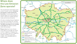
The Low Emission Zone (LEZ) commenced on 4 February 2008.

Updated post (4th January 2012)
http://mapperz.blogspot.com/2012/01/low-emission-zone-map-london-uk.html

London Low Emission Zone Maps
bigger than you thought?
Image source page 10
http://www.tfl.gov.uk/

"The Low Emission Zone (LEZ) affects older, diesel-engined lorries, buses, coaches, large vans (exceeding 1.205 tonnes unladen weight) and minibuses (over eight seats and below 5 tonnes)."

  • The LEZ does not apply to cars and motorcycles.
  • The LEZ applies to all roads and some motorways across most of Greater London NOT just the central London Congestion Charging zone
  • The LEZ operates 24 hours a day, every day of the year which is different to the central London Congestion Charging hours.
  • Your vehicle must meet Euro III standards for particulate matter to be driven within the zone or you will need to pay a £200 daily charge
Over 257 Maps for the fringe boundaries.
** All maps in PDF format some are large file sizes (14mb+)

Labels: , , ,

05 October 2007

Real-Time Travel Information Map - Leeds

Real-Time Travel Information Map - Leeds

The Map shows the location of all traffic affecting Road Closures, Roadworks and Planned Events active now or in the near future.
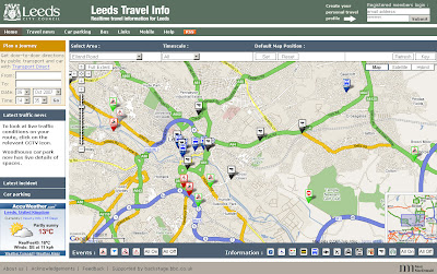
Leeds Travel Information Map
An excellent 'mashup' using numerous data sources including BBC Backstage and Leeds City Council.

Tips on Use: If the map looks cluttered when you visit first use the content panel and switch off all then click individual icons for that layer to be displayed.
Also available is a set your last selected default map position and also remembers your last selection of travel information types and time.

Full Features of the Leeds Travel Information Map
  • Map: the map shows the locations of all traffic affected by road closures, roadworks and planned events that are active now or in the near future
  • Car Parking: A list of up to the minute information on car parking spaces
  • Travel News: This tab contains a searchable list of all traffic affecting road closures, roadworks and planned future events.
  • RSS Feeds: subscribing to the RSS feeds you can receive up to the minute travel information of your choice for the Leeds area
  • Mobile Services: live travel information to mobile phones with Google Maps for Mobile
More Information from the Help Guide
and for a Full Legend for the Map Icons go to the Key

Leeds Travel Information Map


More like this please! Mapperz

Labels: , , , , ,

05 June 2007

Map Transport Icons Clickable - Google Maps

Map Icons Clickable - Google Maps this means that you can plan your bus, train, tram, monorail journey quicker from Google Maps.

Clickable Icons in Google Maps Show Transportation Timetables

http://maps.google.co.uk/maps?f=q&hl=en&q=
waterloo+international&sll=54.162434,-3.647461&sspn=
9.515488,20.43457&ie=UTF8&z=16&iwloc
=0x487604b9cea6720f%3A0x12774cef7cbe6037&om=1


Now click on the tube icon.

Here is a list of the available transport information (Official)
0 - Tram
1 - Subway (Tube)
2 - Rail
3 - Bus
4 - Ferry
5 - Cable car
6 - Gondola
7 - Funicular (Cliff Railway)


Seems to work better in Switerzand and North America - UK just links through to


http://journeyplanner.tfl.gov.uk/ but with the locational information.


Another useful though little know tip for Google Map users out there.

Mapperz

update:
Official Blog Post: Hop on the bus, Gus. Or the train. Or the subway.

And if you know of an online transit site that could provide live feeds directly to the map users there is guidelines available here to do this.
http://code.google.com/transit/spec/transit_feed_specification.htm

Labels: , , , , , , ,

01 March 2007

'Faulty' Fuel Map

'Faulty' Fuel Map locations spreading across the UK.

Faulty Fuel UK Map
Image Source: BBC News

Fuel Outlets have been suppling the UK with Fuel that has been "contaminated"
More on this here:
http://news.bbc.co.uk/1/hi/uk/6409025.stm

But if you have a Vecta-DeLoran your be okay

"I have a nano-silver nutron converter fitted to my Vecta-DeLoran. I just empty waste material into its processor to generate the power I require. I have used empty Tesco carrier bags and wrappers in the past but I found McDonalds waste produces a nice smell."

said StevieB, from Staines

update: traces of silicon have been found in petrol taken from the cars

final update: A Result
http://news.bbc.co.uk/1/hi/uk/6421783.stm

Labels: , , , ,