->

10 May 2011

Bing Maps Interactive SDK (AJAX 7,0)

Bing Maps Interactive SDK (AJAX 7.0)

Bing Maps v7 Interactive SDK

New Features:
  • Create map with map options > Map with inertia intensity: Try varying the inertiaIntensity parameter in the source code window. Set it anywhere between 0 and 1, hit run, and then see what happens when you click and drag the map.
  • Create map with map options > Map with background color: Pull the fully zoomed out map down to see the background color and hit the "Run" button. This shows off the new backgroundColor option and gives you a random color every time. Try typing in your own RGB values and see what you get.
  • Get user location > Get location: If the browser on your phone or PC supports the W3C GeoLocation API, then try out the new getCurrentPosition method to easily find yourself on the map. (Note that the accuracy of this function varies depending on the capabilities of the requesting client. For example, desktop users may see lower accuracy while mobile users see much higher.)
  • Loading dynamic module > Load module - clustering: This shows you how you can use the new module loading methods to register and load your own custom modules (or modules built by other Bing Maps developers).
http://www.bingmapsportal.com/ISDK/AjaxV7

Labels: , , , ,

10 August 2010

MCZ Project Interactive Map

MCZ (Marine Conservation Zone) Project Interactive Map

MCZ Project Interactive Map
Find a huge amount of maritime information, this example shows bathmetry and ship wrecks along the coast of the SW England..

But this map project goes much further:

This project has been jointly funded by Defra, Natural England and the Joint Nature Conservation Committee.
MCZ Project Interactive Map Marine Species
The map contains a huge resource of Marine and Coastal Zone data from Tide Wave Projects to reported Species of marine life surrounding the diverse waters of the United Kingdom.

What is the MCZ Project Interactive Map?

The Interactive Map is a web based Geographic Information System, which is essentially a way of displaying interactive maps online. The MCZ Project Interactive Map allows you to view maps of the United Kingdom and display additional relevant information above it, using layers selected from our marine spatial planning database. The tool also allows you add your own information to the map by drawing and labelling areas that you use or have information about. The MCZ Project Interactive Map is based around the Open Layers interface which is similar to Google Maps, and in many cases the controls will be exactly the same. This similarity will be become apparent as you start to use the tool.

We are using the Interactive Map to achieve two goals:

  1. To communicate the diversity and range of information that is being used by the MCZ Project. We hope that you find the investigation of the spatial data to be an interesting experience and that you discover more about the relationship between mankind and the coasts and seas of the United Kingdom.
  2. To collect information from commercial fishermen who are using the seas around England; however this may be extended to other stakeholder groups such as sea anglers and SCUBA divers. Using the Interactive Map, users can draw and label areas they use or places where they know certain species and habitats occur.
Map Help - and you can become and editor!
http://www.mczmapping.org/WebHelp.aspx#1

View the MCZ Project Interactive Map
http://www.mczmapping.org/#

This Map is another Open Street Map based project

Labels: , , , , , , , , ,

04 June 2010

Historypin - Streetview with History

Historypin - Streetview with History
*
Historypin was built with Google and they provided invaluable support throughout the process.

update: Nice introduction to HistoryPin with this video.


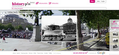
"Historypin is a online tool that acts as a digital time machine, allowing people to view and share history in a totally new way."

Historypin beta - Streetview with History
Sharing Past memories and important events with Google Streetview and Historical Photography display correctly in 4D space.

"Historypin invites the public to dig out, upload and pin their own old photos, as well as the stories behind them, onto the Historypin map. Uniquely, Historypin allows users to layer their old images onto modern Street View scenes, revealing a series of windows into the past."
http://www.wearewhatwedo.org/generations/

Interactive Timeline
One of the most useful tools for finding historical photographs is the interactive timeline that can span as far back as 1840's.

Historypin beta - Streetview with TimeLine Slider
Use the time-line interactive slider to find more recent or past photographs whilst in the map/streetview mode.
Using Google Maps and Street View technology, Historypin aims to become the largest user-generated archive of the world’s historical images and stories.

The site invites the public to dig out, upload and pin their own old photos, as well as the stories behind them, onto the Historypin map. Uniquely, Historypin allows users to layer their old images onto modern Street View scenes, revealing a series of windows into the past.


Trafalgar Square, London.
http://www.historypin.com/photos/search/streetview/1/radius/969778/bounds/56.523139564372194,9.99755859375,50.90303283111257,-18.12744140625/zoom/0/geo/53.800651,-4.064941/date_from/1840-1-1/date_to/2010-6-3/yaw/292.37/pitch/5.95

same link in human terms: http://tinyurl.com/historypin-trafalgar-sq

More information:
http://googlemapsmania.blogspot.com/2010/06/largest-archive-of-photos-on-google.html

Main website: http://www.historypin.com/

Go straight to the Map - http://www.historypin.com/photos/


Creators -
http://www.wearewhatwedo.org/

Labels: , , , , ,

10 February 2010

New York Times - 3D Olympic Venues Map

New York Times - 3D Olympic Venues Map

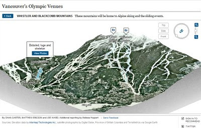
If you want just one map to locate events for the Winter Olympics in Vancouver 2010 then this Interactive and Animated 3D Map created by The New York Times is it.

New York Times Olympic Venues Mapped - 3D Animated
  • Highly Detailed
  • Smooth Animated Zooms to Event Locations
  • Interactive (Users can control 3D aspects panning and zoom)
  • Informative Details on the Sport persons to look out for
  • High Quality Action Photographs.
Clicking from the Map above smoothly zooms to:
New York Times Olympic Venues Mapped - 3D Animated Bobsled
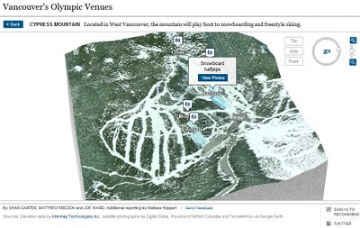
Users can control Aspect using the controls in the top right corner.

New York Times Olympic Venues Mapped - 3D Animated Halfpipe
Using Flash there is a quick response to load up a very impressive 3D Animated Map

Well done to
SHAN CARTER, MATTHEW ERICSON and JOE WARD; Additional reporting by Melissa Hoppert


Sources: Elevation data by Intermap Technologies Inc.; satellite photographs by Digital Globe, Province of British Columbia and TerraMetrics via Google Earth

Visit the New York Times - 3D Olympic Venues Map
http://www.nytimes.com/interactive/2010/02/09/sports/olympics/2010-olympics-venue-map.html


Labels: , , , , , , ,

06 November 2009

Network West Midlands - Live Bus, Train and Metro Map

Network West Midlands - Live Bus, Train and Metro Map

Network West Midlands - Live Bus, Train and Metro Map
Interactive Travel Map - this is information overlaid on to Google Maps showing live information from http://www.networkwestmidlands.co.uk/

The Interactive Live Map shows:
  • Bus stops (real time bus timetables, where available) rail stations (train departure and arrival times) and Metro stops.
  • See forthcoming departures (live for rail and bus)
  • Link through to full timetables relevant for each station and stop
  • See the 8-letter bus stop code for a particular bus stop.
The map functions:
  • Search box Type a road, town or village, postcode, bus stop name or bus stop code list matching bus stop results in the left panel.
  • Map top strip Tick/untick a checkbox to show/hide those map icons.
  • Map & markers You can pan, zoom and scroll using your mouse and the Google map controls (and the small map view in the bottom right-hand corner).
  • Left side links Select Rail or Metro to list local rail or metro stops
  • Left panel Bus stops matching your search are displayed as lists of links.
  • Quicklist Moves the map to an locality on the drop-down list.

View the Live Interactive Map
http://netwmtravelmap.com/

Labels: , , , , , , , ,

02 February 2009

New BBC Weather Maps Website (Revamp)

New BBC Weather Maps Website

[8.30am currently this has not 'switched over' - probably because of 'snow' on the internet]
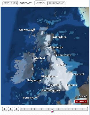
BBC Weather - Revamp New Maps
New, Faster and more Interactive Maps from the BBC
(now supports tabs and is updated much more often)


Today the BBC have launched the biggest re-vamp for the Weather Pages of the BBC site.
Huge improvements across the board.

"The BBC Weather site has been redesigned and from Monday 2nd February accessible to all users."
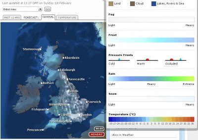
BBC Weather - Revamp New Maps Legend
Compasion legend made more accessible for users.
The Beta version of the new site has been live since September 2008 to give you a preview of the new look and a chance to try the new site slowly the BBC have been adding new features and content and fine-tuning it based on users feedback.

"The new site is designed to give you all the information you need for your local area, from a detailed forecast for the next 24 hours and 5 day outlook to maps, video and any other relevant information we have."

Technology has also developed since the Weather site was first created and we have been able to take advantage of this to improve your experience of our site.

The Changes:
Indication of confidence frequency with which the forecasts are recieved from the Met Office.

All forecasts have a margin for error. BBC Weather developing a new feature that will allow our forecasters to publish an ongoing discussion of confidence in the forecast.

Detailed Forecasts
Today's forecast for UK locations on the main weather site will no longer be illustrated by one summary symbol.

A three-hourly breakdowns to show more clearly how the weather will change over the 24 hours to come.

Local Forecasts:
The design of the new site is based on giving you all you need for your local area - BBC has been creating a 'one-stop shop' for each location.

Forecast Videos
Embedded forecast videos on each local forecast.

For UK locations, you will be able to watch your latest regional TV weather forecast, as broadcast on TV, during the week in addition to our UK and World Summaries.

Easy access to all forecast data - page modules so that you can 'close' content you don't use so often.
(These settings will be stored so each time you come back, the page will be as you left it. The content won't disappear from the page so you know you can always get it if you need it).

Better navigation
The site is now much 'flatter' which means that it is easier to navigate.

All forecast information for a location on one page this means that once you've searched for your location you won't need to go looking for other content that relates to it.

The search is also being improved to accommodate spelling mistakes and identify the nearest forecast for a location you are looking for even if the Met Office don't provide an exact forecast.

Personalisation
You will be able to save up to 6 favourite locations in the 'My Weather' module so you can access these forecasts quickly.

More interactive elements
Each module is interactive - you can open and close them depending on whether you are interested in the forecast info or not.

The map presenter will also be more interactive and you will be able to view maps for surrounding areas without leaving the page.

"Although on the 2nd February the main content will be available in the new look and feel, some content will still only be available on the old site. We will continue to move information from the old to new site over the next few months as well as develop new features on the site."

View the new Website
http://www.bbc.co.uk/weather/

(users can access the new site by clicking the 'new site arriving' image)

Labels: , , , ,

23 January 2009

Interactive Google Maps API - Playground - New!

Interactive Google Maps API - Playground - New!

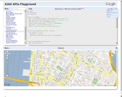
Confused by code? Want to see how the pieces of code fit together to create Google Maps API mashups? Interactive fully editable code and then click Run to see the result.

Interactive Google Maps API Playground

Code Menu button allows the user to save the source
Export creates an id and uses the 'http://savedbythegoog.appspot.com' (Google App Engine) to make a page live, login and and this is saved in a 'Saved Code' Menu

Custom Saved AJAX Playground
Saved Code [requires login]

Here is an excellent new section to the Google Maps API Documentation http://code.google.com/apis/maps/documentation/reference.html Code Samples > Code Playground - New!

Hopefully this inspires more developers and people interested in creating their own maps based on Google Maps. This new interactive page gives users a jump start in the right direction.


Virtual Earth has had an Interactive SDK page for quite a while now available at:
http://dev.live.com/Virtualearth/sdk/

(not editable code unless copy and paste into an editor (notepad or dreamweaver etc))

The Google Interactive Playground is now also available for:

Visualization API (includes Chart API)
Search API
Language API (Translate)
Blogger Data API
Libraries API
Earth API
Feeds API
Calendar Data API


Source:
http://google-code-updates.blogspot.com/2009/01/playing-around-with-googles-ajax-apis.html

Labels: , , , ,