->

04 June 2010

Historypin - Streetview with History

Historypin - Streetview with History
*
Historypin was built with Google and they provided invaluable support throughout the process.

update: Nice introduction to HistoryPin with this video.


"Historypin is a online tool that acts as a digital time machine, allowing people to view and share history in a totally new way."
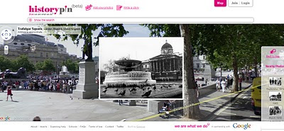
Historypin beta - Streetview with History
Sharing Past memories and important events with Google Streetview and Historical Photography display correctly in 4D space.

"Historypin invites the public to dig out, upload and pin their own old photos, as well as the stories behind them, onto the Historypin map. Uniquely, Historypin allows users to layer their old images onto modern Street View scenes, revealing a series of windows into the past."
http://www.wearewhatwedo.org/generations/

Interactive Timeline
One of the most useful tools for finding historical photographs is the interactive timeline that can span as far back as 1840's.

Historypin beta - Streetview with TimeLine Slider
Use the time-line interactive slider to find more recent or past photographs whilst in the map/streetview mode.
Using Google Maps and Street View technology, Historypin aims to become the largest user-generated archive of the world’s historical images and stories.

The site invites the public to dig out, upload and pin their own old photos, as well as the stories behind them, onto the Historypin map. Uniquely, Historypin allows users to layer their old images onto modern Street View scenes, revealing a series of windows into the past.


Trafalgar Square, London.
http://www.historypin.com/photos/search/streetview/1/radius/969778/bounds/56.523139564372194,9.99755859375,50.90303283111257,-18.12744140625/zoom/0/geo/53.800651,-4.064941/date_from/1840-1-1/date_to/2010-6-3/yaw/292.37/pitch/5.95

same link in human terms: http://tinyurl.com/historypin-trafalgar-sq

More information:
http://googlemapsmania.blogspot.com/2010/06/largest-archive-of-photos-on-google.html

Main website: http://www.historypin.com/

Go straight to the Map - http://www.historypin.com/photos/


Creators -
http://www.wearewhatwedo.org/

Labels: , , , , ,

07 July 2009

Land of Britain | Map Viewer (Historical)

Land of Britain | Map Viewer (Historical)

Update: 08/07/09

Looking for Vision of Britain Maps?
"A vision of Britain through time - Including maps, statistical trends and historical descriptions"
Vision of Britain - Historical Maps
Mapping includes:
  • Topographical Maps
  • Land Utilisation Maps
  • Administrative Maps
http://vision.port.ac.uk/maps/
(hint:click bigger map)

Update: 4pm [07/07/09] The BBC have created a video on this mapping application (hopefully all users can see the video not just UK users)
http://news.bbc.co.uk/1/hi/england/8138486.stm

"The Land of Britain web site was created by the
Great Britain Historical GIS Project, based at the University of Portsmouth, with funding from the Frederick Soddy Trust.
A Vision of Britain through Time (new site) covers the whole of Britain, but not at this level of detail."

More information on this can be found here
A GENERAL INTRODUCTION TO LAND USE MAPPING IN BRITAIN
http://riga.iso.port.ac.uk/django_projects/doc/pamphlet/chapter1/

Land of Britain 1800's Brighton & Hove
The First Edition Maps, dating back to the 1800's

"We are deeply grateful to Rex Walford, director of the Land Use UK Survey, for letting us draw on the teacher's pack he created with Tony Binns, featuring Brighton area maps from the 1960s and 1990s survey, and to the copyright holder for the Land Utilisation Survey of Great Britain for allowing us to re-publish Dudley Stamp's maps. We thank the British Library of Political and Economic Science for scanning the Stamp field survey sheets, and the British Library for scanning the Ordnance Survey First Series sheet."


A GENERAL INTRODUCTION TO LAND USE MAPPING IN BRITAIN
http://riga.iso.port.ac.uk/django_projects/doc/pamphlet/chapter1/

The Historical Maps overlayed together using opacity side-bars can show users the urbanisation of Brighton and Hove over many years.


Land of Britain 1934 Brighton & Hove
More recent (1934) colourful maps show the large development along the coastal towns

Land of Britain 1967 Brighton & Hove
Full colour, largescale highly detailed mapping (1967) of Brighton & Hove. Showing the full and large urbanization sprawl of the town and city

The Map Viewer
http://riga.iso.port.ac.uk/django_projects/maps_full/

Full Acknowledgments
http://riga.iso.port.ac.uk/django_projects/info/

Openlayers was used to develop this Mapping Application

Source:
http://www.craigbellamy.net/2009/07/07/a-vision-of-britain-through-time/

Labels: , , , , , , , , ,

26 March 2009

Cartifact Maps (Beta)

Cartifact Maps (Beta)

Cartographic Maps made available with Cartfact Labs and Google Maps API.

Cartifact Maps Custom Map Beta
Take Google Maps and add your own custom tiles, integrate local search, historic maps (1880, 1928 & 1981) and you get a nice cartographic mashup.

"Our goal to create a visually enhanced environment for custom cartography focuses on Los Angeles for this beta release."
Bruce Daniel

Director, Cartifact Labs

Cartifact Maps Historic Map Zoom Zens - Local Search
Lens Zoom - can display historic, Google maps/aerial of Cartifact's own custom tiles.

Additional Feature
s:
Lens control (see image above) - no need to zoom in - the lens does the work
Local searches on Hotels, Residential Properties and Commercial Spaces.
Drag zoom.

Try the Cartographic Mashup - http://maps.cartifact.com/

Mission
Cartifact Labs’ mission is to identify, explore and provide expertise in emerging technologies related to the creation and use of maps.

Labels: , , , , ,