->

16 June 2010

Transport for London - Data Released June 2010

Transport for London Data Released June 2010

Transport for London Data Release
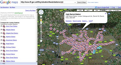
Tube Stations Data (but not up-to-date) in KML format

Data is Available from Here [Feb 2010]
Metadata is Here

Mapped


What is Free?

The London Datastore currently hosts the following travel-related data sets: Via the TfL developer page:

Station Locations

TfL Pier Locations

Live Traffic Cameras

Oyster Ticket Stop Locations

Static files on GLA servers

Cycle Hire Locations

London Underground Signals Passed at Danger

TfL Investment Programme

TfL Business Plan

Riverboat Timetables

The LDS says it is "currently working" on also releasing more datasets by 30 June 2010, including

- Bus Stops

- Bus Routes

- RODS Data (Rolling Origin and Destination Survey Data).

[Note: LIVE FEEDS ARE NOT AVAILABLE signing up required.]

Links to Examples:

http://www.tfl.gov.uk/tfl/businessandpartners/syndication/example-feeds.aspx

Thanks to the Guardian and it's campaign

Labels: , , , , , ,

16 September 2009

ALL 1,841,177 UK POSTCODES FREE'D?

ALL 1,841,177 UK POSTCODES FREE'D?


Example of UK Individual Postcodes

Example of UK Individual Postcodes (density)
image source:

http://da.vidnicholson.com/2006/12/uk-postcode-coverage-map.html


According to the Guardian:

"Wikileaks is hosting what it says is a copy of the entire UK postcode list, last updated on July 8 2009, that contains "all 1,841,177 UK post codes together with lattitude [sic] and longitude, grid references, county, district, ward, NHS codes and regions, Ordnance Survey reference, and date of introduction. The database ... is over 100,000 pages in size."

The 230MB file, zipped to 20MB, does indeed contain a huge slew of postcodes in comma-separated form, with those details as headers for each column.

Oh my. We have no idea who has leaked this, but it is the gateway to some valuable information: Royal Mail, as we ascertained previously in the Free Our Data campaign, sells the Postcode Address File (aka PAF) for a considerable sum, and makes a good profit on it: in August 2007 the postal regulator Postcomm revealed that PAF operations made a profit of £1.58m on revenues of £18.36m, all but £4m from resellers."

Data seems to be

Postzon™

"links Postcodes and addresses to geographical data"

http://www.royalmail.com/portal/rm/jump2?mediaId=400088&catId=400084

so there is a licence cost:

System licence £1,000
Multi-system licence £3,000
Corporate licence £25,000

Full story:

http://www.guardian.co.uk/technology/blog/2009/sep/16/wikileaks-postcode-file-free-data

More information on UK Postcodes

http://en.wikipedia.org/wiki/Postcodes_in_the_United_Kingdom

If you want a non-derived Royal Mail/Ordnance Survey and Free Postcodes without an annual licence.

http://www.freethepostcode.org/currentlist


Labels: , , , , , ,

24 April 2009

London Marathon Maps 2009

London Marathon Map 2009

Racing starts 9.00am BST on Sunday 26th April 2009

9am Elite Women's Race Starts
9.25am Wheelchairs Race Starts
9.45am Elite Men's Race Starts
9.45am Mass Starts

BBC Sport London Marathon Map 2009 - Virtual Earth
BBC using Virtual Earth - No Route. and have some issues with the users in the US not centering on London. (Overlay a KML file would provide a route)
http://news.bbc.co.uk/sport1/hi/athletics/8011891.stm

How 'live' is this map? [Race starts 9.00am BST on Sunday 26th April 2009]

New content is added to the map as soon as it becomes available - in many cases there is a short delay involved, as video, audio and images must be received and edited before being published.

But it looks like nothing had changed.

You need to refresh the page to see updates. Some points on the map, for example image galleries, update with fresh content as the marathon progresses. In other cases, older content is removed from the map and replaced by newer content from a similar area.

It would have been useful to see the full marathon route on this map.

We agree. This was not possible this year, but we expect to offer this in future.

Overlay a KML file would work.

For a Route Map see the Guardian
http://www.guardian.co.uk/lifeandstyle/interactive/2009/apr/22/london-marathon-route-map and click 'Runner'
Guardian London Marathon Route Map 2009
Image from The Guardian

Route Planner
http://www.realbuzz.com/flmroutes/map.html
links from the Official Site - http://www.london-marathon.co.uk/site/
(not the best - needs updating from last year)


View Larger Map
This route might incorrect as it is from an old source (2005) but took 0.22 seconds to find

Labels: , , , , , ,

11 March 2009

Mapping the News API (Guardian)

Mapping the News API

The Guardian is now Geocoding/Mapping it's News Articles with it's New OpenData APIMapping the News API - Guardian

A neat way of finding news articles by location.

Experiment with the new API
http://www.guardian.co.uk/open-platform/getting-started

Start Page for Guardian Map API
http://guardian.apimaps.org/index.html

GeoCode this! (try a search term)
http://guardian.apimaps.org/search.html

CloudeMade Mapping
http://guardian.apimaps.org/map.html


Note: Articles that do not have a location can be updated by readers

Example search
http://guardian.apimaps.org/search.html?q=London

For Budding Developers:
Data Structure of the API
http://guardian.apimaps.org/data.html

Map API integration:
News articles by The Guardian.
Maps © 2009 CloudMade, map data CC-BY-SA OpenStreetMap.org contributors.
Place searching by Flickr. Font reset by YUI. Cheerleading by SteveC.
Design and code by Stamen Design.

Source:
http://www.programmableweb.com/mashup/guardian-api-maps

Labels: , , , , , , ,

05 July 2007

Free Our Flood Mapping!

A recent article on this Mapperz Blog showed OnOneMap Maps (using Google Maps API) was better than the Environment Agency own Online Mapping.
http://mapperz.blogspot.com/2007/06/environment-agency
-adds-pollution-maps.html

But due to the nature of 'public' data the Environment Agency has told OnOneMap to remove this service as the data is their copyright - excuse me but this is UK tax payers money

"We have had to withdraw our popular and innovative flood map layer, ironically and sadly during one of the worst periods of flooding the UK has ever experienced. The Environment Agency claims they have copyright over the information, and despite the fact that tax-payers’ money has paid for it to be collected in the first place, apparently the tax-payer cannot benefit from innovations like our housing and flood map combination.

For more information on the lack of access the British public have to their data, visit The Guardian’s Free Our Data campaign."

Mapperz hoped the Guardian is reading about this!

Yes they have

http://technology.guardian.co.uk/weekly/story/0,,2118152,00.html

Free Our Data Please. So we can make use of it and provide useful services to the public - like property mapping. Knowing if your house is 'likely' to flood before buying it.

Labels: , , , , ,

04 January 2007

Crown Copyright crushing UK Mapping Innovations

This is a post to make people aware that government agencies are stifling UK innovations.


"Public money paid for it - but the public can’t view because of crown copyright"

Says the Guardians Free Our Data Campaign

"Imagine flying at rooftop height up the Thames. You dive under Tower Bridge, then twist between the Gherkin and Tower 42 skyscrapers. As the London Eye looms, you bank right and dive into a translucent globe which transports you into the middle of St Paul's cathedral."


But you can't put it online!

"Although Virtual London was funded by another state body, the computer model cannot be posted on the web without infringing Ordnance Survey's copyright."

"Public money funds it, yet "public" copyright keeps it shut away."

But how can Geographically data be locked down to some ceramic hard drive and not accessible to the people who paid for it?

Nicely timed just ahead of Christmas, the Department for Constitutional Affairs has put its Statute Law Database online. You can search for any extant law, and various others - including how upcoming legislation will affect existing laws.
This was protected under crown copyright so why can this be released to the public free of charge and available online?

Come on Ordnance Survey sort your out of date crown copyright.
Reduce your prices to commercial vender's and you will gain more consumers and increase your incomes 10 fold.

Sources:
http://freeourdata.org.uk/blog/
http://technology.guardian.co.uk/weekly/story/0,,1981821,00.html
http://www.ordnancesurvey.co.uk/oswebsite/aboutus/
yourinforights/copyright/index.html

Even little company Google are having issues with Ordnance Survey -

"The sticking point is understood to be Google's attempt to negotiate a fixed fee for the data, rather than accepting Ordnance Survey's practice of charging by the number of transactions. Ordnance Survey would not comment on the specific case, but said that a fixed fee would "wreck the level playing field for other partners" - and it should be noted that it is obliged to treat all customers (including itself) on the same terms. OS said it is happy for its data to be used in a "Google-type" environment. "Sites such as Multimap and Streetmap use our data and their services are freely available to the public over the web.""

Labels: , , , , ,