->

28 March 2011

Twitter Nano

Twitter Nano

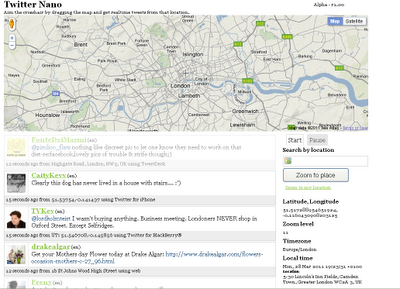
Search by Location (Cross-Hairs) and get real-time tweets from twitter.
Twitter Nano Map

A real-time geolocation Twitter experience Aim the crosshair by dragging the map and get realtime tweets from that location. It's that simple.

Twitter Nano
http://www.twitternano.com/

Source:
http://www.programmableweb.com/mashup/twitternano

Labels: , , , , ,

07 January 2011

#ukfuel Bing Maps

#ukfuel Bing Maps

#ukfuel Bing Maps

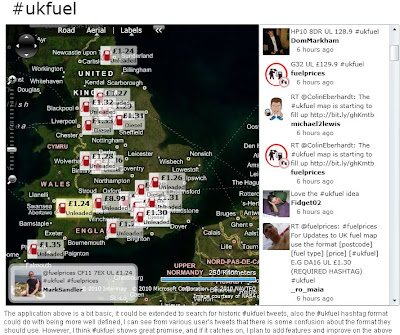
Same concept as Ben Marsh's http://uksnowmap.com/ but with UK fuel prices and UK Post Codes and twitter mapped out on Bing Maps

The format of #ukfuel tweets is as follows:
[postcode] [fuel type] [price]

For example:

DA16 UL £1.30

http://www.scottlogic.co.uk/blog/colin/ukfuel-a-twitter-bing-maps-mashup-for-tracking-fuel-prices/

cross-posted from http://bingmapswatch.blogspot.com/

Labels: , , , , ,

17 September 2010

Twitter: Tweet With Your Location

Twitter: Tweet With Your Location
(This additional service is now being rolled out across the world)

Twitter's Tweet With Your Location feature allows you to selectively add location information to your Tweets. This feature is off by default and you will need to opt-in to use it. You can find out how to start using this feature on the How to Tweet With Your Location help page; this article is an overview of the feature.Mapperz Twitter Tweet Location Map

Once you've opted-in, you will be able to add your location information to individual Tweets as you compose them on Twitter.com and with other applications or mobile devices that support this feature. The location information that is shared publicly can be either your exact location (your coordinates) or your place (like a neighborhood or town).

Tweeting with your place or coordinates can add context to your updates and help you join the local conversation, wherever you are.

Helpful links for Your Questions:

How do I tweet with my location?

http://support.twitter.com/articles/122236

http://support.twitter.com/articles/78525-about-the-tweet-with-your-location-feature


This service was first introduced in November 2009 [USA only] via the twitter api, now this is available in users settings (off by default).

Most likey because FaceBook Places has been rolled out globally too.
http://www.bbc.co.uk/news/technology-11342802

Labels: , , , , ,

07 July 2010

Google Maps v3 New Map Mashups - July 2010

Google Maps v3 New Map Mashups - July 2010

Here are some of the newest v3 Google Maps

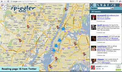
Spiggler.com Searches Twitter with your location.
Spiggler - Twitter Google v3 Map
Updates as you pan the v3 Google map nice integration with the twitter api.

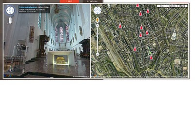
Streetview Inside
http://weblab.ab-c.nl/streetview v3 google map


Location Search Tool for Twitter
Find Geo-Twitter comments via this v3 Twitter Location search Google Map


The Grand Canyon - v3
Maptiler Custom v3 - The Grand Canyon
Using USGS DRG tiles as a custom tiled Google Maps v3.

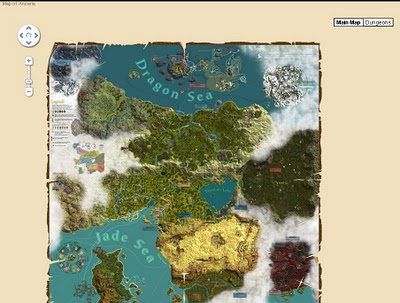
Game:Map of Ancaria
Map of Ancaria_v3 Google Maps
Very well illustrated Map of Ancaria [Sacred Game] - users can switch between this main map and dungeons custom map.

Missouri State Campus Map - Mobile
Missouri State University Campus v3 Mobile Map
Clean, Fast with campus overlay implemented in v3 for mobile users.

Don't forget that you can style your own map in v3 see the previous post.

Have you made your own v3 custom map like this? Add a comment and mapperz will post an update.

Labels: , , , , , ,

25 June 2010

State of the Map 2010 - Girona, Spain - Open Street Map

State of the Map (SotM 2010) will be held in Girona, Spain from the 9th - 11th July 2010

State of


the Map!

SotM 2010 location by using Open Street Map

http://www.openstreetmap.org/?lat=42.6&lon=3.11&zoom=6&layers=B000FTF&mlat=41.98523&mlon=2.81161

"The 4th Annual State of the Map is in beautiful Girona, Spain. Consisting of three days, you have fantastic opportunities to discover how OSM is used in business, meet new international OSM friends and tune up on your mapping skills.

Friday starts off with a bang on Business day. Want to use the freely available OpenStreetMap map data in your business? Opportunities abound to hear how other enterprises utilize OSM. You’ll also gain insight on tools that are available to hit the ground running with OSM! Business day is simply a powerful day not to miss. Check out our Friday program.

Community, community, community! The weekend is all about the great clan that is OSM. Packed with talks, panels and social events, all day and into the night! New to OpenStreetMap? Come and meet us and learn what we are passionately working on, who the movers and shakers are and join in on the fun! Have a look at our program for Saturday and Sunday."

Schedules is here: http://stateofthemap.org/schedules/
Mapperz interesting picks:

Friday 9th July 2010: http://stateofthemap.org/schedules/friday/
"Geodata from public sector sources" sounds interesting
Saturday 10th July 2010: http://stateofthemap.org/schedules/saturday/
"Outreach to Non-Technical Communities" sounds promising.
Sunday 11th July 2010: http://stateofthemap.org/schedules/sunday/
"What I’d like to do with Mapnik" cartographic changes coming?

Promotion links of State of the Map 2010
Twitter some of SOTM's tweets to your many followers: http://twitter.com/sotm

Or tweet something new, like this cool new video about the conference: http://stateofthemap.org/impressions/

Blog:Write a quick blog post - be inspired by some SOTM blog posts:

http://stateofthemap.org/program-announced-for-the-state-of-the-map-2010/

Labels: , , , , ,

05 May 2010

UK Election Map #ge2010

UK Election Map #ge2010
UK Election Geo.me tweets map

View live geotagged tweets over a constituency map of Britain. Recent geotagged tweets are shown, so the tweets you see have been sent from the actual locations shown.

Twitter Controls: Use the yellow search box to search for specific terms. You can disable automatic reloading, force a reload and clear the map using the panel controls. Loading status and popular hash-tags (#geo2010) are shown at the bottom of the panel.

Constituency Data: the constituency map uses the new 2010 boundaries released as Ordnance Survey Open Data, coloured by the notional 2005 election results, as provided by the Guardian Data Store. Zoom closer to see constituency names. Boundaries for Northern Ireland constituencies are not yet available as open data.

Important Note: the map shows only properly geotagged tweets, made by users who have enabled this feature. This represents only a small proportion of all tweets.

UK Election Map
http://www.geo.me/election

source:
http://googlemapsmania.blogspot.com/2010/05/uk-election-on-google-maps.html

Labels: , , , , , , ,

25 March 2010

@Nomads_land got Ordnance Survey Maps!

@Nomads_land got Ordnance Survey Maps!

What's the story here?

Ordnance Survey have helped the request for Ordnance Survey maps for a long walk (7,000 miles) around the United Kingdom for 3 UK Charities by Nathaniel Severs
Ordnance Survey
http://www.ordnancesurvey.co.uk/oswebsite/

The Three Charities:
  1. Southampton General Hospitals Paediatric Physiotherapy department
  2. The Stroke Association
  3. The Mammal Society
The request:
requested: 10:33 AM Mar 16th via Twitter on the web
S: Right Twitter,Nat is after some maps for the Scottish leg of the walk. SO, has anyone got OS Maps of scotland they could donate?Please RT

@mapperz picked up this request after following the daily tweets from @Nomads_land on his walk around the UK coast.

Basically mapperz has a number of good contacts, those contact have even better contacts.
Enter @StevenFeldman to the request and things really start moving and thanks to him Ordnance Survey have given the maps away for the Scottish leg of the 7,000 mile journey. That's over 40 1:25,000 Explorer Maps and a geo success of social networking that can be achieved.

More info on the guy doing the work:
"My names is Nathaniel Severs, I am 24 years old and in 2010, I am walking the entire coastline of mainland Britain (7,000 miles) for three great charities."Nomad's Land Big Walk Blog
Keep up to date on the Big Walk on http://natsevs.wordpress.com/

"I set out from Portsmouth on 10 January accompanied only by a large rucksack carrying my tent and kit. I camp most nights but am open to offers for accomodation! The entire journey will be completed using leg power and if there is a bridge, I will be crossing it (so Anglesey and the Isle of Skye will both be on the agenda). I will stay true to the coastline at all times, so if there is a ferry across a river (the River Dart, for example) that is not classed as coastline, then I will allow myself to take a ferry if one is available. But a ferry cannot be used at any other time. I aim to be home by Christmas!"

The journey so far
Nats Big Walk Route
Natathan is currently along Pembrokeshire Coast Path [Fishguard] (a very nice walk rain or sun)
Follow his progress here http://natsevs.wordpress.com/progress/

Many thanks to:

@Nomads_land for taking up the challenge to walk around the entire UK coast
http://natsevs.wordpress.com/

Steven Feldman (@StevenFeldman)
http://giscussions.blogspot.com/

Ordnance Survey for being so quick to respond and making the solution to the request.
hopefully a post on http://magazine.ordnancesurvey.co.uk/magazine/tscontent/editorial/exploremagazine/ about this soon?

Social networking Site Twitter - http://twitter.com/ connecting us all up.

and myself Mapperz @mapperz for helping a good cause.

Labels: , , , , , , ,

19 June 2009

Map Channels - June 2009

Map Channels - June 2009

A busy month for Map Channels: They have released the following 3 new features this month alone.


• 17 Jun 2009 : Iran Election Twitter Map

Iran Twitter Map - Map Channels
Mapping tweets about the Iran Election using twitter #tags

• 15 Jun 2009 : Map Feed Converter v1 (beta)

A utility to convert data between KML and tab-delimited format and text to KML.

• 1 Jun 2009 : Map Channels Version 3.02

Which helps you create maps for your own website quickly and easily.

Updated to fix some bugs and add new features.

Also see http://www.mashedworld.com/ for Google Maps and Street View Projects

Look forward to even more to come...

Recently Related:
http://googlemapsmania.blogspot.com/2009/06/iran-protests-on-google-maps.html
To keep up-to-date with the latest from Map Channels use the RSS Feed on the News page
http://www.mapchannels.com/News.aspx

If your bored on a Friday try the Quiz Maps:
http://www.mapchannels.com/QuizMaps.aspx

Labels: , , , , , , ,