->

17 September 2010

Twitter: Tweet With Your Location

Twitter: Tweet With Your Location
(This additional service is now being rolled out across the world)

Twitter's Tweet With Your Location feature allows you to selectively add location information to your Tweets. This feature is off by default and you will need to opt-in to use it. You can find out how to start using this feature on the How to Tweet With Your Location help page; this article is an overview of the feature.Mapperz Twitter Tweet Location Map

Once you've opted-in, you will be able to add your location information to individual Tweets as you compose them on Twitter.com and with other applications or mobile devices that support this feature. The location information that is shared publicly can be either your exact location (your coordinates) or your place (like a neighborhood or town).

Tweeting with your place or coordinates can add context to your updates and help you join the local conversation, wherever you are.

Helpful links for Your Questions:

How do I tweet with my location?

http://support.twitter.com/articles/122236

http://support.twitter.com/articles/78525-about-the-tweet-with-your-location-feature


This service was first introduced in November 2009 [USA only] via the twitter api, now this is available in users settings (off by default).

Most likey because FaceBook Places has been rolled out globally too.
http://www.bbc.co.uk/news/technology-11342802

Labels: , , , , ,

22 April 2010

Unlock Places API - Geo Data Finder

Unlock Places API - Geo Data Finder

"The Unlock Places API was recently upgraded to include Ordnance Survey’s Open data. This feature rich data from Code-Point Open, Boundary-Line and the 1:50,000 gazetteer includes placenames and locations (points, boxes and shapes) and is now open for all to use"

Unlock API Map OSM

Results Clearly displayed on Open Street Map using the API.

Unlock services are middleware, which means they're intended to be used by another application- a script, or a web site.

Unlock places gazetteer search can be used in "real time" - looking up the coordinates of postcodes to search against your own database - or in "batch mode", using the gazetteer to georeference a large collection of media files.

Unlock API Examples

Display in Google Earth - Image http://unlock.edina.ac.uk/map.html

Example Request:

http://unlock.edina.ac.uk/ws/nameSearch?name=edinburgh&format=html

You can see the results in different formats by using a different format parameter

  • 'html' to see results on a web page, with individual features on a map
  • 'kml' to see KML data suitable for import into Google Earth
  • 'json' for a Javascript Object Notation suitable for re-use in web applications
  • 'xml', which is the default option.

Other Output formats:

  • GeoJSON
  • GeoRSS
  • TXT
More Examples and More Detials on the API

http://unlock.edina.ac.uk/queries.html#examples

http://unlock.edina.ac.uk/api.html

Get Started: http://unlock.edina.ac.uk/getstarted.html

source :http://unlockdata.wordpress.com/2010/04/21/unlock-places-api-version-2-2/

Labels: , , , ,

19 November 2009

PublicEarth 'Wiki for Places'

PublicEarth 'Wiki for Places'

PublicEarth is a'wikipedia for places' that can be extended by users. Using Google Maps to display 'crowdsourced' Points of Interest [POI] locations.
Guests can view the data in a read-only format whereas registered users rate places,create collections and can personalise their suggestions.

Public Earth Points of Interest Southampton
Clean, Fast Public Earth Points of Interests [POI] Layers.

example:
http://www.publicearth.com/explore/2c51606a-c99f-11de-addb-00163e75a173?swx=-1.5652084350585938&swy=50.844538088124565&nex=-1.2411117553710938&ney=50.96534632163772#page=0


PublicEarth has currently 4 million + POI's and rising, all grouped into a number of categories. PublicEarth has over 450 categories, these include the usual categories such as restaurants and entertainment but also more unusual topics.

Full List of Catergories
http://www.publicearth.com/categories/browse
include
Arts, Culture & Entertainment
Recreation & the Outdoors
Shopping
Community Essentials
Places to Stay
Food & Drink.

Some different catergories to the norm.
Fossil Sites, Kiteboarding Locations, Public Rooftops, Shipwrecks, Sundials, Street Art

The site allows the user to plan a trip or a day out and then send the saved locations to a GPS device, a mobile phone or e-mail them to friends. PublicEarth also lets you display your saved places on your own website or blog by creating and embedding a widget.

The site even comes with an API that allows developers to access PublicEarth's huge database of recommendations.

Labels: , , , ,

19 May 2009

Wolfram Alpha Maps

Wolfram Alpha Maps

Wolfram Alpha Maps
The new 'computational knowledge engine' creates maps for distances between 2 locations in the world on the fly.

Example
http://www29.wolframalpha.com/input/?i=London+to+Sydney


For more tips on find out facts and geographical (geography) start here
http://www29.wolframalpha.com/examples/PlacesAndGeography.html

Labels: , , , ,

26 July 2008

Channel 4 - Big British Food Map

Channel 4 - Big British Food Map

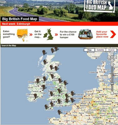
Channel 4 Big British Food Map
Channel 4 (UK TV Channel) has launched a Google Map that displays over 50,000+ places...

"
I love talking about food almost as much as I love eating food. I don’t think I’m alone in that. It’s the one topic of conversation that EVERYONE has got an opinion on. If I were to ask you to tell me about an interesting place you‘ve been to where you ate or bought something delicious, what would your recommendations be? What is so great about that place? That’s where the Big British Food Map comes in. It’s about finding and sharing those great little places that people know"
Catherine Jackson, 4Food, Channel 4

Users can add their favourite food places and maybe win a prize.

We [Channel 4] want to know about that little place you know, and why you love it. By adding a place, you could be in with a chance of winning a fabulous hamper of food. We'll be giving away one each month until November 2008.

Before you add your place, check to see if we've already got it by searching. (If it is already on the map, we still want to know what you think of it).

View the Map
http://www.channel4.com/food/big-food-map/explore-map/

Labels: , , , ,

04 July 2007

Intelligent Free UK Geocoder - All in One.

Update: Just added [Map-Satellite-Hybrid] Controls
Please use the Official Method
http://gmaps-samples.googlecode.com/svn/trunk/geocoder/singlegeocode.html


Twickenham RFC in Satellite Mode

So you can now see Sports Stadiums

Mapperz looked into revamping the UK Geocoder.

and now rolled it into one.

You can now search UK Addresses, UK Postcodes, Global Airports and Global Place names and find the Latitude and Longitude for all of them - to those who don't know what this is called, it is called Geocoding.

Here are a few Examples to get you searching

London Heathrow Airport, you can use the code 'LHR'
Under the Map is the Latitude and Longitude displayed 'up to' full 12 decimal places (but you only need 6 decimal places for the likes of using Google Maps)

UK Geocoder Airports - LHR


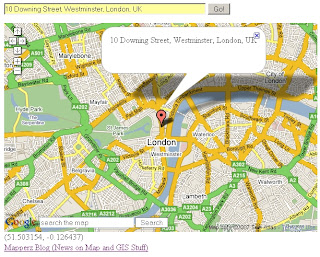
Now for a famous Address
10 Downing Street, Westminster, London, UK

UK Geocoder Addresses - 10 Downing Street

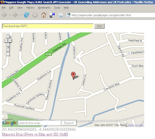
Now how about a large sporting venue?
Twickerham Rugby Football Club. You got it

UK Geocoder Points Of Interest - Twickerham RFC

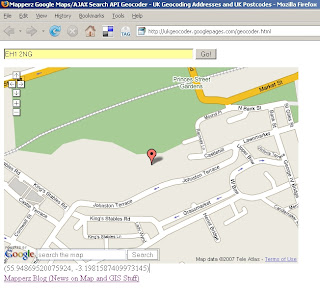
And Famous Postcodes
EH1 2NG
(Edinburgh Castle)

UK Geocoder Postcode - EH1 2NG
Please note if you move/pan on the map the lat and lng is automatically updated.
This is simple and smart. Hence why Mapperz likes it.

How is this done?
This is using Google Map API and Google AJAX Search API - Local Search which was improved for UK last week.
Mapperz just displays the returns the Latitude and Longitude at centre of the map after the information is parsed and centred using Local Search.


to remove the icons - just reload the page 'Ctrl F5'.

The Code is available via View>Page Source 'Ctrl+U'

If you want to have your own version you will need change the
Google Maps API Key
Google AJAX API Key
And find a Webserver (Mapperz using Google Pages in this case)

Labels: , , , , , , ,