->

22 August 2011

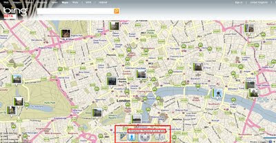
Bing Maps Streetside - London UK

Bing Maps Streetside - London UK

Bing Maps Streetside - London UK
Streetside is now available for some parts of London, England

Bing Maps Streetside - Westminster Bridge London UK
Westminister Bridge, London Bus and London Eye Iconic Landmarks, but do not expect 'Google Streetview' type functionality this is more a slide-show of images.


More information on Streetside
http://www.microsoft.com/maps/en-GB/streetside.aspx

View Streetside - London UK (click the icon next to Traffic)
http://www.bing.com/maps/?v=2&cp=51.50085314131346~-0.12088798043215165&lvl=14&dir=0&sty=r&trfc=1&form=LMLTCC

cross-posted from BingMapsWatch

Labels: , , , ,

15 January 2010

New Bing Streetside Coverage: Vancouver and Whistler

New Bing Streetside Coverage: Vancouver and Whistler for the Winter Olympics 2010

Streetside Bing Maps Vancouver
Blue represents the Bing Streetside coverage for Vancouver show here.

Streetside Bing Maps Vancouver
Downtown Vancouver, lots of big features gearing up the Winter Olympics 2010 will be held on 12th–28th February.

Streetside Bing Maps Whistler
Whistler is also in the streetside coverage. Lot of building and construction works in preparation of the big events next month.

Google also have Streetview Coverage of Vancouver & Whistler

View Bing New Streetside in Vancouver
http://www.bing.com/maps/explore/#5872/lat=49.282699&lon=-123.119823&alt=13.53&z=30&h=44.9&p=11.7&pid=5082/5003/0.5071=WNB&1.6002=q:Vancouver:lat:51.5120151209378:long:0&o=&a=0:1&n=0

Related links
http://www.vancouver2010.com/

http://en.wikipedia.org/wiki/2010_Winter_Olympics

Previous Post
http://mapperz.blogspot.com/2009/12/big-street-view-update-for-canada.html

Source:
http://www.bing.com/toolbox/blogs/maps/archive/2010/01/15/new-streetside-coverage-vancouver-and-whistler.aspx

Labels: , , , , ,

14 December 2009

Mapquest Streetview (called 360) - Street Level Imagery

Mapquest Streetview (called 360) - Street Level Imagery
Mapquest Steetview 360
You can now view MapQuest Maps in a whole new way. We have developed a simple, easy-to-use interface that fits seamlessly into the MapQuest mapping experience you have come to know and understand. 360 View provides fantastic panoramic views (360° horizontally and 160° vertically) of any given image within the 360 View coverage area
*selective USA Cities only
Mapquest Steetview 360 mode
orange glow represents 360 street level imagery available when the '360 view' option is on.

The quality of the imagery is not as high resolution as Google (Streetview) or Bing Streetside but then they require post-processing bluring faces, mapquest does not.
The Orange 'bubbles in' 360 mode could be made transparent but do indicate direction of the next photo in a simple manner.


Mapquest API
currently 360 mode is not available in the mapquest api
http://developer.mapquest.com/web/products/beta-releases

source:
http://blog.mapquest.com/2009/12/11/street-level-imagery-comes-to-mapquest-com-as-360-view/
screen shots:
http://www.mapquest.com/360-details

Labels: , , , ,

03 December 2009

BING Maps Explore (Streetside)

BING Maps Explore (Streetside)
*Sliverlight required & in beta
**Streetside mode is in some USA Cities only currently

BING Maps Explore Streetside
Looks familiar to Google StreetView but is a light blue indicating 'StreetSide' coverage.

BING Maps Explore Streetside - Streetside Mode
Streetside mode - has similar features to streetview, controls are slightly different.

BING Maps Explore Map Apps
Apps for your BING Maps - Nearby App (useful), Traffic, Twitter App displays geo-tweets, many more to explore.

BING MAPS BETA NEARBY CLUSTER MARKERS
Nearby Map App- Markers(Icons) group in clusters when there is not enough space to display all markers at zoom levels.

BING MAPS BETA STREETSIDE
BING Maps Explore has new controls - automatic 'finds' the best map mode for your zoom level

try it
http://www.bing.com/maps/explore/

warning to firefox users - can cause memory leaks and freeze up your browser.

source:
http://www.bing.com/community/blogs/maps/archive/2009/12/02/bing-maps-adds-streetside-enhanced-bird-s-eye-photosynth-and-more.aspx

Labels: , , , , , ,