->

07 October 2010

Google Latitude Goes Desktop

Google Latitude Goes Desktop
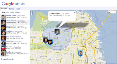
Google have launched Latitude with a desktop iGoogle gadget to help you stay in touch with friends and family that may not have a smartphone. Google learned that a desktop experience is important to you even if you’re already using Latitude on your phone. Today, you can now visit a dedicated site that makes it easier than ever to use Latitude when you’re already on your computer. From the Friends tab, you can:
  • See where your friends are on Google Maps
  • Add friends and accept sharing requests
  • Control your privacy settings

Google Latitude Goes Desktop

Do more with Latitude
You’ll also now find Latitude and Latitude apps together in one place. After browsing your friends list, go to the History or Apps tabs to turn on optional Latitude apps such as:
Google Latitude Apps (must be signed into Google)
https://www.google.com/latitude/apps

Labels: , , , ,

25 March 2010

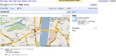
Google Bookmarks Your Maps

Google Bookmarks Your Maps

Simple, no lon
g urls can be private or public (to share)

"
Today we’re debuting lists in Google Bookmarks, an experimental new feature that helps you easily share those sites with friends."

Google Bookmarks Share Maps
Google bookmarking your maps - Tip: With the Google Toolbar simply click the star and it will be saved in your favourite bookmarks. No need to worry about very long urls that can be broken in emails etc.

https://www.google.com/bookmarks/l (Google Account Required)

Privacy
http://www.google.com/support/bookmarks/bin/answer.py?hl=en&answer=159231

Using Maps with Google Bookmarks
http://www.google.com/support/bookmarks/bin/answer.py?hl=en&answer=162168

source:
http://googleblog.blogspot.com/2010/03/collaborative-bookmarking-with-lists.html

Labels: , , , ,

01 May 2009

ArcGIS 9.3.1 - GIS Data Portal - Share Geospatial Data

ArcGIS 9.3.1 - GIS Data Portal - Share Geospatial Data

ArcGIS 9.3.1 - GIS Data Portal
Find available datasets with the new ArcGIS 9.3.1 - GIS Data Portal

Version: 9.3.1.25

Features of the GIS Portal Toolkit Include:

Data Categories:
Web pages that help you discover and access a wide variety of geographic information for a particular data theme or data community.

Current Event or Application Topics:
Web pages that help you discover and access a wide variety of geographic information for a special application area or current event.

Search Page:
The Search page enables you to discover and access a wide variety of geographic information within the GIS Portal Toolkit. This geographic information, provided by government, commercial, and non-commercial organizations, includes map images, map services, geographic datasets, geographic activities, spatial solutions, clearinghouses, and land references.

Performing a Search:
To find content, you can set a search area by place name or you can use the Map Viewer to define your search. Once your search area is established, you can set your search criteria based on content type, such as map service, geographic datasets, activities, etc., data theme, keywords or date ranges. The results of the search are displayed along with metadata and if appropriate a map.

View Metadata:
You can use the metadata detail and the full metadata view to browse through information to locate what you are looking for. Map data can be viewed in the Map Viewer or with GIS software to display multiple data sources from the GIS Portal Toolkit along with data from local sources.

Map Viewer:
The Map Viewer tool allows you to interact with map services referenced in the metadata, and to browse through federal baseline datasets. The Map Viewer also allows you to save maps for later use, set transparency levels, query map information, and provides rich functionality to overlay map services.

Publish Data:
You can provide geographic data by publishing map services and images, geographic datasets, geoservices, spatial solutions, geographic and land reference material, and geographic activities or events to share with others through submission of on-line provider forms within the GIS Portal Toolkit portal. Publishing is performed via an online form or an upload utility.

http://gptogc.esri.com/GPT931/catalog/content/about.page
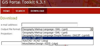
ArcGIS 9.3.1 Download data no shapefile?

Just odd that ESRI don't have ESRI Shapefile or File Geodatabase formats available... but do have their competitors formats...
A new version of http://www.geographynetwork.com/


source:
http://mandown.co.nz/esri/arcgis-9-3-1-arrives/ [Twitter Feed Sidebar]

On Friday, May 01 2009 At 9:10 PM
"Better to download than to get the DVDs by regular snailmail. I still do not understand why large software companies just stop to send DVDs by regular mail and just offer them for download instead. The copy protection is still the same and by using bittorrent- technology it will even go fast without too heavy load on their servers!"

Yes, why not save on costs and delivery ESRI and make your products download-able [with secure and authorized access]
All the Service Packs and Patches are only available as download (some are a big as the original installer too).

Labels: , , , , , ,

01 August 2008

ESRI Geoprocessing Center Now Open

ESRI Geoprocessing Center Now Open

ESRI Geoprocessing Center Now Open
Finally ESRI have opened up the 'Geoprocessing Center' for all, users can upload and share geoprocessing models and scripts.

There are 4 parts to the Geoproccessing Center:

Geoprocessing Blog - News and Posts

Models and Scripts Gallery - Where users can upload/download and share.ESRI Geoprocessing Center Models & Scripts

Forums - Discussions on Geoprocessing Models

Knowledge Base - Technical Articles

Not much content currently but in the coming months hopefully will be as popular as the Arcscripts portal has been for many years.

*Important*
Please read these important guidelines if you wish to upload a model or script to the Geoprocessing Center - the more people share the more everyone will get out of this.
http://blogs.esri.com/Dev/blogs/geoprocessing/archive/2008/07/29/Guidelines-for-submitting-tools-to-the-Model-and-Script-Tool-Gallery.aspx
or direct link to the Guidelines for submitting Model and Script Tools [PDF]

Labels: , , , , , ,

13 March 2007

Google Earth in Tandem

Your friends can now follow along with you in Google Earth

Unype via Skype sharing Google Earth locations

required
  • a friend
  • Skype (voice/video over ip)

Synchronising two users with Google Earth installed on each others pc, using the popular skype program to send the information and unype sends basic kml to the viewers google earth app.

Good for demo's and showing friends places.

more info and video
http://digitalurban.blogspot.com/2007/03/skype-goolge
-earth-multi-user-google.html

http://www.gearthblog.com/blog/archives/2007/03/
skype_unype_multiuse.html

Source: Nafcom

Labels: , , , , ,