Virtual Earth News & Weather Silverlight Demo
Virtual Earth News & Weather Silverlight Demo

Very impressive Silverlight Demonstration showing weather (cloud/radar) across the USA.
(Hurricane Ike can be seen in the bottom right)
Silverlight 2.0 interface and Virtual Earth tiles with real time weather feeds showing current weather conditions.
There also is a radar refresh rate 5 minutes or 15 minutes
http://demo2.ischosting.net/weathersldemo/
[requires Microsoft Sliverlight]
Other geospatial applications that can be used with Virtual Earth:
* Windows Communications Foundation (WCF)-based web services
* Windows Presentation Foundation (WPF) Map and Tile renderer
* Virtual Earth Base Map Data and Imagery
* Silverlight 2.0 Map Control
* Spatial Data Import (Shapefile, SQL Server 2008, ArcSDE and PostGIS)
more information
http://www.mapdotnet.com/Pages2.0/index.aspx
An Up and Coming Virtual Earth Events
| | 26 September 2008 11:00 GMT, London (so 12 noon as UK is on BST) |
Following the success of the previous webcast, the second of our quarterly Virtual Earth technical briefings is once again presented by Johannes Kebeck, EMEA Virtual Earth Technology Specialist.
This webcast is aimed at developers and offers an opportunity to get an update on the Virtual Earth platform. Additionally you will learn some of the latest tips and tricks and can take part in an online Q&A with Johanne.
http://msevents.microsoft.com/CUI/WebCastEventDetails.aspx?EventID=1032385964&EventCategory=4&culture=en-GB&CountryCode=GB
The New Version of Virtual Earth
| | Thursday, October 02, 2008 9:00 AM Pacific Time (US & Canada) (5pm BST) |
Microsoft is excited to announce the latest version of the Virtual Earth platform, which can now deliver the Virtual Earth mapping experience on the desktop, on mobile devices, and via broadcast. The new release features mobile support, expanded international mapping, richer imagery, a broader range of data, and improved functionality. Organizations using Virtual Earth can see more and do more than ever, with enhancements that allow users to find, discover, and visualize data in new and innovative ways.
http://msevents.microsoft.com/CUI/WebCastEventDetails.aspx?EventID=1032388370&EventCategory=4&culture=en-US&CountryCode=US
Virtual Earth Globalisation BBC
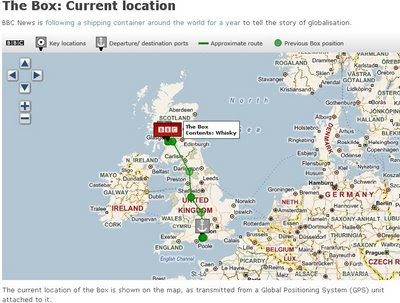
'The BBC BOX' that is getting tracked around the globe using a GPS beacon that is attached to a Shipping Container.
Not very exciting stuff currently but in a year hopefully the paths of the all the routes it has taken will be shown on the Map.
Update: They have just filled the BBC Box with whiskey in Glasgow.

This Shipping Container is going to be tracked for a year.
BBC Virtual Earth is being used to track the box at a 12 hourly rate.
(Thanks to Keir Clarke for finding that one)
Labels: GPS, Mapping, Sliverlight, Tracking, Virtual Earth


0 Comments:
Post a Comment
<< Home