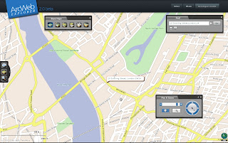
ArcWeb Explorer (Beta) 2.0
ArcWeb Explorer (Beta) 2.0
ArcWeb Explorer 2.0 application, which offers powerful Web map rendering with desktop-like functionality.

source: ESRI
The rotating map is a clever bit of code - the text flips (renders) itself when it goes beyond 180 degrees.
ArcWeb Explorer 2.0 Application | ArcWeb Explorer 2.0 Flex API | ArcWeb Explorer 2.0 JavaScript API |
Exposes ArcWeb Services functionality through easy-to-use widgets | Enables developers to build and/or customize applications | Offers the use of a powerful subset of ArcWeb Services functionality |
| Offers the ability to quickly find locations, pan and zoom, and choose a map type | Provides access to all ArcWeb Services | Provides access to ArcWeb Services content |
| Provides access to street, street tile, aerial imagery, hybrid (integrated street and aerial), shaded relief, and topographic maps | Allows for easy and powerful ArcWeb integration inside Adobe Flex Builder | Enables easy integration of mapping functionality and content into HTML Web applications |
source: ESRI
To use this service you will be required to login in.
ArcWeb 2.0 Home Page

JavaScript Sample

Flex Example
Both have the code generated on the fly - therefore it is faster to get up and running with your own apps and data.
Is this to challenge the likes of Google Maps, Virtual Earth and Yahoo Maps API's?
We will see...
Mapperz
Labels: 2.0, API, ArcWeb, Beta, ESRI, Explorer, Flex, Javascript


1 Comments:
Cool post - check out my post where you will find tips and tricks on how to use AWX.
Post a Comment
<< Home