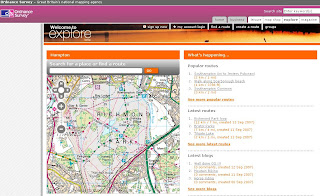
Ordnance Survey Explore (Beta)
Ordnance Survey Explore

Ordnance Survey have launched 'OS Explore', a website designed for walkers, runners, hikers, cyclists, anyone with the interest with the great outdoors and sharing their routes and personal favourite places.

Though there is room for improvement:
- No Help or FAQ - to get non map people to 'get started'
- No Editing of your own routes (that's a bit silly)
- No 1:25,000 (Explorer) Mapping is all 1:50,000 (Landranger) (OS have copyright on their own data surely?)
- No Polygon creation (Area) - only Lines and POI Points.
- No Export so cannot use the route in a GPS
Well it's a start from the Ordnance Survey - but clearly in Beta.
Needs to be more 'MyMaps' in functionality
Add your comments on the service - maybe they take note, maybe not.
*Routes are British National Grid not WGS84
Ed Parsons (ex Ordnance Survey) also mentions it in his blog
Official Reply on the editing of routes
"Unfortunately, at the current time, users are unable to edit routes once they have been saved. However, before saving, users are able to undo waypoints they have plotted and remove their points of interest. There are several usability changes envisaged for the next release and this is an area we would like to see improved. The site is still in its beta stage so obviously we are keen to hear about any issues encountered."
Labels: Explore, Explorer, Landranger, Ordnance Survey, POI points, Routes


0 Comments:
Post a Comment
<< Home