->

13 July 2009

Cartagen (0.5) - OSM Cartographic Mapping - New!

Cartagen (0.5) - OSM Cartographic Mapping - New!

Newly release of the dynamic mapping framework Cartagen.

"In this release, we’ve taken a shot at rendering any location on the planet (drawing, of course, on data from OpenStreetMap), and at rendering a much greater density of map features with richer styles. The has come a long way, and we hope it makes designing your own map easier while allowing even greater possibilities for unique and compelling designs."


Take 6 minutes to learn how to download, set up and customise OpenStreetMap vector data.
Very informative video.
Credit to Jeff Warren and Ben Weissmann

More information and setup instructions are on Cartagen’s wiki, and our live demonstration site at cartagen.org has been updated.

Suggestion: As mentioned on the Mapperz Cloudmade post.
"Reorder Layers, ranking structure - sometimes having polygons above features can be useful, like a masking out polygon."

More Information
Getting Started
http://wiki.cartagen.org/wiki/show/GettingStarted
Source:
http://unterbahn.com/2009/07/announcing-cartagen-0-5/

and the main site: http://cartagen.org/ where data can be downloaded (json format)

Downloads
http://code.google.com/p/cartagen/downloads/list

@mapperz

Labels: , , , , ,

20 May 2009

Google Maps Data API - New!

Google Maps Data API - New!
(so new not had chance to play with it!)

Google Maps Data API - New!

Why Use the Google Maps Data API?

  • Storage scales simply with usage. You shouldn't have to worry about maintaining a data store to build a cool Google Maps mashup. Focus on building the client, and we'll provide hosting and bandwidth for free.
  • Geodata is accessible across platforms and devices. With many client libraries and clients, accessing stored geodata is possible from anywhere, whether it's on the web, a mobile phone, a 3D application, or even a command line.
  • Realtime geodata requires realtime indexing. For a lot of geographic content, freshness is important. Geodata from the Google Maps Data API can be instantly indexed and made searchable in Google Maps.
  • Rendering geodata is better and faster with the right tools. Through JavaScript, Flash, 3D, static images and more, we'll continue to provide better ways to render your content to meet platform and latency demands.

Some Applications That Have Already Been Made:

  • My Maps Editor for Android allows users to create and edit personalized maps from an Android mobile phone. Integration with the phone's location and camera makes it easy to document a trip with photos and text on a map.
  • ConnectorLocal is a service that informs users about the places where they live, work and visit by gathering trusted hyperlocal information from many sources. Using the Google Maps Data API, ConnectorLocal makes it easy for users to import and export geodata in and out of Google Maps, and also improves their ability to have data indexed in Google Maps for searching.
  • My Tracks enables Android mobile phone users to record GPS tracks and view live statistics while jogging, biking, or participating in other outdoor activities. Stored with Google Maps Data API, these tracks can be accessed, edited and shared using the My Maps feature in Google Maps.
  • Platial, a social mapping service for people and places, uses the Google Maps API to host geodata for community maps on both Platial and Frappr.
More information and Source:
http://googlegeodevelopers.blogspot.com/2009/05/
introducing-google-maps-data-api-in.html

Labels: , , , ,

22 October 2007

MapCruncher (VE beta Version) +Quick Guide

MapCruncher (VE beta Version) Quick Guide

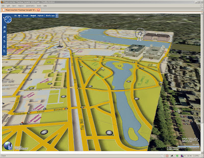
Custom Map in 3D MSVE
Your own Custom Map in Virtual Earth in 3D (London is a bit too flat) Buildings are from Microsoft Virtual Earth.

What is it?
Crunches Maps!
Generates Custom tiles in from one image into tiles at different zoom levels

Okay what do I need?
MapCruncher VE version (beta)
some space on your pc
*not much knowledge on web programming

.net version 3.0 framework is required to use this program (but it's worth having anyway)

How to use it
have a digital version of your map - and make sure you have copyright on the map source.
(tif,gif.jpeg,pdf,png can be used.)
at least 150dpi, try at 300 and your map will be clearer (less fuzzy)


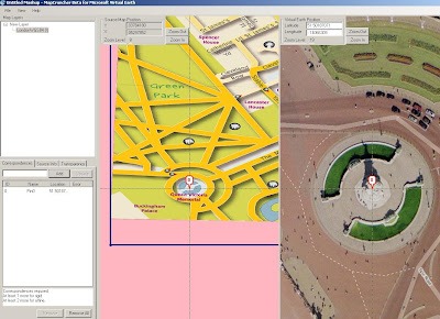
Georeference the image - this shows you how - at least 3 points are needed - 4 is best.

Map Cruncher Georeferencing
locate both 'locations' and add a marker on virtual earth base, once three locations are done it can be locked.

Lock the Image to the Virtual Earth (VE) map

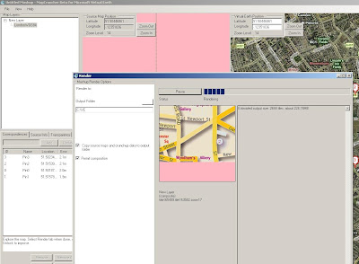
Rendering.... THE MAP CRUNCHING BIT! (can take a while with big images) - this one took 20 minutes.
The good thing here is that it is an automated process - only 'map crunching' computer time

Map Cruncher Rendering
This is automatic - just have a new folder for the images and html to go.


This even creates a sample html page to get you up and running.

But I want 3D!

OK you cannot view 3D on your local computer - but you can if the 'map crunched' data is uploaded to a webserver (http only)

File sizes - ok the little issue here is that many images created for zoom and panning.
This map is 236MB so it can take a while to upload to a webserver..

But then once on the webserver - you can view it in 3D

try
http://www.mapsinternational.co.uk/ve/samplepage.html
try and let the image load up first (post-cache)

(ok, ok London is a bit flat!)

But this can be done for more undulating areas!

Can this be used for other mapping API's?
Looking into this using Google Maps API, Multimap API and Yahoo Maps API.
(in theory yes)

Mapperz

Labels: , , , , , ,