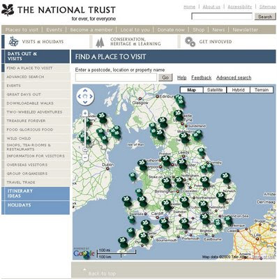
National Trust Map (Beta)
National Trust Map (Beta)

The hundreds of locations of National Trust owned properties are now available on a Google Map, the large national trust icons are 'clusters of' properties zooming in allows individual places of interest be click-able with summary and open times tabs.
"Welcome to our brand new map."
"We are still developing this super tool that will help you make the most of your days out with us.
Let us know whether we're on the right track or if we have room for improvement by leaving some feedback."
So how does it work?
- Each small pin represents a National Trust property. Click on the pin and you will get some property information, local weather, travel directions and more.
- Larger pins represent clusters of places to visit. When you click on one you will get a zoomed-in map showing the area in more detail. Each National Trust property is then shown with a small pin, and as before, you select the pin you are interested in for further information."

Need Inspiration? Then the "Inspiratior" can help you find a day out - just use your desired location Town or Postcode in the tool and choose a distance.
Mapperz - leaving feedback:
Nice work National Trust - now putting both those excellent tools into one box would be a really powerful tool.
Good for school summer holidays and getting families out into the countryside.
Labels: Beta, Days Out, Inspirator, Locations, Map, National Trust


0 Comments:
Post a Comment
<< Home