->

20 May 2009

Healthy Pet Mobile Vet - Service Area Map

Healthy Pet Mobile Vet - Service Area Map

Healthy Pet Mobile Service Areas Google Maps API
Brian Peyser has created Service Area Polygons for Healthy Pet Mobile Vet.
Provides both response by time and traffic overlay from New Market, MD.

Works really well:
how this was achieved?

"I did this with an adaptation of Marcelo's code:
http://maps.forum.nu/gm_driving_radius.html
I made the script return a pretty accurate set of points within the
limit of my algorithm based on both distance and time. You can see the results at:
http://www.healthypetmobilevet.com/area.shtml
Just keep this in mind--when I did a really accurate set of points it only took a few tries to exceed Google's limit. Also, it can take a little while to get the polygon. Make sure you've got it right before you start running the requests. When I did it, I actually made the polygons using OpenJUMP (which is a free GIS program) based on teh points output be the script, then converted to KML from Shapefile. You might be able to do this better than I did, but to get an accurate polygon you'll need a lot of requests. If you have a lot of regions to create it will take a long time, since you'll have to spread it over multiple days. However, you may be able to improve it by narrowing the search region. Instead of searching in a circle from each point, you just search a region that overlaps based on distance. In other words, do what you've already done to limit your search space."

If you want interactive 'Drive Time Zone' see the older post
http://mapperz.blogspot.com/2008/07/arcgis-javascript-extension-for-google.html

links to this:
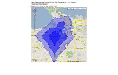
Interactive ESRI Drive Time Google Map
Mapperz Version is based in Vancouver, Canada, but also covers the USA.
(Uses the ESRI ArcServer sample server as the backend for geoprocessing)

http://mapperz.googlepages.com/DriveTime_ESRI_GMAP.html*

*note googlepages will be closing 1st July 2009 - will move this demo by then and update the link.

source: Google Maps API group
http://groups.google.com/group/Google-Maps-API/browse_thread/thread/9ef5ee515db6fe07#

Labels: , , , ,

10 July 2008

ArcGIS JavaScript Extension for the Google Maps API

Updated see red and blue below

ArcGIS JavaScript Extension for the Google Maps API
"The ArcGIS JavaScript Extension for the Google Maps API allows you to use your ArcGIS maps and tasks in the framework of Google Maps. There are many reasons to use this extension to expose your GIS data. Perhaps your audience already knows how to use Google Maps. Perhaps you're already familiar with the Google Maps API. Or maybe you just like the look and feel of the Google base maps."

Google Maps + Powerful GIS Analysis
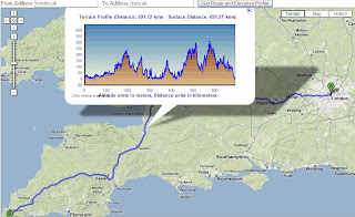
ESRI GMAP API Directions with profile UK
Here is a Google Maps Direction Route - with the added profile of the route generated by ArcServer. (click image to see live example)

Here is another example of adding GIS capabilities to Google Maps.

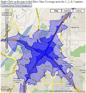
ESRI Google Maps API DriveTime
Drive Time Polygons (1,2 & 3 minute driving time polygons) on the fly - overlaid on Google Maps. (click image to see live example)
Custom version http://mapperz.googlepages.com/DriveTime_ESRI_GMAP.html
(Drive Time only works in the US and Canada)

How is this geo-processing action created?

Create Drive Time Polygons - ArcGIS Model
Image source: http://globe5.arcwebservices.com/arcgisoutput/Network_ESRI_DriveTime_US/CreateDriveTimePolygonsDisks.htm

ArcGIS comes with Model Builder here geoprocessing functions Make Service Area Layer, Add Locations are just some of the core processing elements to create Drive Time Polygons.

This is the start of some serious and powerful tools that will and can be built on to 'enrich' the map user.
This provides them with detailed information that can be manipulated and customized to the users specifications on the fly.

Other possibilities at the Geo-Processing Service examples here
  • Display your own maps on top of a Google Maps base map.
  • Execute a sequence of GIS models and display the results in Google Maps.
  • Search for features in your GIS data and display the results on Google Maps.
  • Find addresses using your own address locator and display the result on Google Maps.
  • Display attributes from your GIS data on the map using the Google Chart API.
  • Allows others to add GIS functionality from your server as a Google Mapplet.
The future looks bright with GIS software companies taking on popular mapping API's

Please note there is an ArcGIS JavaScript™ Extension for Microsoft Virtual Earth™ version as well.

Reported by Google Map Mania from this Blog


Labels: , , , , ,