Did you mean? Google Maps
Did you mean? Google Maps

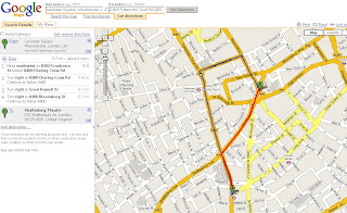
New yellow markers indexed to the sidebar help narrow down places of interest.
You can also get directions to each one.
Lots of 'GIS' going on underneath to do this.
Now you can find points of interest and do not need to have an end address/location to get map directions.

Driving Directions? But sometimes quicker to walk.
(red line would be shortest route to walk and still uses Teleatlas data)
**red line added by mapperz
Suggestion:
Would be handy in large cities to have a 'walk to' option as you can see in Leicester Square you get sent around the one way system. But Leicester Squaree is pedestrian only and would take only a few minutes to walk.
If driving you might miss the show.
based on the post
http://google-latlong.blogspot.com/2008/01/no-address-required.html
Labels: Did you mean?, GIS, Google Maps, new feature, walk it


0 Comments:
Post a Comment
<< Home