->

11 April 2011

New Zealand 1:50,000 Topo Maps

New Zealand Topo Map

New Zealand Topo Map is an interactive topographic map of New Zealand using the official LINZ's 1:50,000 / Topo50 and 1:250,000 / Topo250 maps.http://www.blogger.com/img/blank.gif

New Zealand 1:50,000 Topo Maps

http://www.topomap.co.nz/NZTopoMap/9432/Vampire/Westland

Lord of the Rings (and The Hobbit 2012) Fans will be interested in
http://www.topomap.co.nz/NZTopoMap/7770/Lindis%20Pass/Otago

Labels: , , , ,

11 July 2010

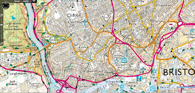
Ordnance Survey Map in Bing Maps - Silverlight

Ordnance Survey Map in Bing Maps 1:25k and 1:50k Mapping Scales

Ordnance Survey 50k Landranger Bing Maps Silverlight

Ordnance Survey 1:50,000 (Landranger series) scale mapping in Bing Maps

Ordnance Survey 25k Landranger Bing Maps Silverlight
Ordnance Survey 1:25.000 (Explorer series) scale mapping in Bing Maps

http://uslot.com/NewBingTestPage.html

Source:
http://bingmapswatch.blogspot.com/2010/07/ordnance-survey-map-in-bing-maps.html

more details on the implementation from this blog
http://jimlynn.wordpress.com/2009/11/12/ordnance-survey-maps-in-bing-maps-silverlight-control/

Labels: , , , , ,

18 December 2007

Defra UK Airport Noise Maps

Defra UK Airport Noise Maps Available


"In 1996 the European Commission issued a Green Paper in which it was stated that an estimated 20% of the EU citizens were exposed to noise levels that scientists and health experts considered to be unacceptable, at which most people become annoyed, sleep is disturbed and health may be at risk."

UK Airports Noise Maps from Defra
All available from
http://www.defra.gov.uk/environment/noise/ambient.htm#aviation
(1 to 4mb PDF's with Ordnance Survey 1:50,000 Rasters included, Arcview 3.2 was use - north arrow and scale bar giveaway there.)

Airports included:
Birmingham International Airport
Blackpool Squire’s Gate Airport
Bournemouth Airport
Bristol Lulsgate Airport
Coventry Airport
Leeds Bradford Airport
Liverpool John Lennon Airport
London City Airport
London Gatwick Airport
London Heathrow Airport
London Luton Airport
London Stansted Airport
Manchester International Airport
Newcastle International Airport
Nottingham East Midlands Airport
Shoreham Airport
Southampton Eastleigh Airport
Southend Airport

Glossary to help understand the maps

Decibel (dB)
The decibel (dB) is a logarithmic unit of measurement that expresses the magnitude of a physical quantity relative to a specified or implied reference level. Its logarithmic nature allows very large or very small ratios to be represented by a convenient number. Being a ratio, it is a dimensionless unit. Decibels are used for a wide variety of measurements including acoustics, and for audible sound A-weighted decibels (dBA) are commonly used.

dB(A)
A unit of sound pressure level, adjusted in accordance with the A weighting scale, which takes into account the increased sensitivity of the human ear at some frequencies

LAeq,T
The notional A-weighted equivalent continuous sound level which, if it occurred over the same time period, would give the same noise level as the actual varying sound level. The T denotes the time period over which the average is taken, for example LAeq,8h is the equivalent continuous noise level over a 8 hour period.

Lday
The A-weighted average sound level over the 12 hour day period of 0700 – 1900 hours.

Levening
The A-weighted average sound level over the 4 hour evening period of 1900 – 2300 hours.

Lnight
The A-weighted average sound level over the 8 hour night period of 2300 – 0700 hours.

Lden
The day, evening, night level, Lden is a logarithmic composite of the Lday, Levening, and Lnight levels but with 5 dB(A) being added to the Levening value and 10 dB(A) being added to the Lnight value

LAeq,16h
The A-weighted average sound level over the 16 hour period of 0700 - 2300

Noise Bands
Areas with similar noise exposure in 5 dB(A) ranges according to the key shown with the maps

Noise Contours
Lines showing the locations with the same noise exposure according to the key shown with the maps.

Labels: , , , , , ,

14 November 2007

New Draggable Geograph Map (Beta)

New Draggable Geograph Map

Geograph Map just got easier to use...

Geograph Draggable Map Beta
New draggable maps using Ordnance Survey 1:50,000 mapping (Landranger series)
What is Geograph?
"The Geograph British Isles project aims to collect geographically representative photographs and information for every square kilometre of the UK and the Republic of Ireland, and you can be part of it."

Draggable Geograph Map of Great Britain (beta)

64% complete for the British Isles
http://www.geograph.org.uk/numbers.php

How is this done?
Servers “Jam” “Toast”, “Scone” and “Crumpet” (a good start to any day)
http://blog.dixo.net/2006/07/28/geograph-servers-coming-to-life/

This site uses an Educational Licence from the Ordnance Survey
"Great Britain 1:50 000 Scale Colour Raster Mapping © Crown copyright Ordnance Survey. All Rights Reserved. Educational licence 100045616."

How is the done?
"But basically it just (JUST!?) involved cutting up 12GB of raw tiff files from the
OS, into more manageable png chunks using imagemagick, and then on
demand but cached on disk it cut into png tiles. The overlay is also
generated in php, ondemand and cached with memcached. And of course it
using openlayers as the client library."
Barry Hunter (nearby.org.uk)

Mapperz thanks Barry for sharing his time and tweaks on this. Well done and keep up the good work.


Just a quick note to UK Teachers out there - the 16th November is the last date to get Free Ordnance Survey Maps (for 11 year olds)
http://freemaps.ordnancesurvey.co.uk/freemapsfor11yearolds/

Labels: , , , , , , ,

25 September 2007

MultiMap Open API + Ordnance Survey Data

MultiMap Open API + Ordnance Survey Data

Ordnance Survey 1:50,000 Data is now accessible to API developers

is it true?

You can Zoom in and Pan.

A bigger version is available here
http://mapperz.googlepages.com/Multimap_Sample_OS50k_bigger.html

"At Multimap we’re [they are] very proud of the wide range of local and global mapping data available on our website and through our API, and are committed to providing as much of this data via the Open API as we [they] can. To that end, we’re very pleased to announce the availability of Ordnance Survey Landranger maps (at 1:50000 scale across zoom levels 13, 14 and 15) through the Open API.

The Landranger data covers England, Scotland and Wales and provides a wealth of topographic features, such as contour lines, tourist attractions and historic features such as Roman roads. These maps are great for walkers, cyclists, or for providing detailed maps of rural areas. We can’t wait to see how people make use of them through the Open API."


http://blog.multimap.com/


A good but probably expensive (regards to licensing) move by Multimap.

Mapperz

Labels: , , , ,