->

30 May 2011

Open Street Map Linked GeoData

Open Street Map Linked GeoData (RDF)

Making geographical data more discoverable and accessible:
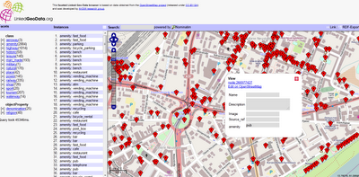
Open Street Map Linked GeoData


LinkedGeoData is an effort to add a spatial dimension to the Web of Data / Semantic Web. LinkedGeoData uses the information collected by the OpenStreetMap project and makes it available as an RDF knowledge base according to the Linked Data principles. It interlinks this data with other knowledge bases in the Linking Open Data initiative.


The Linked Geo Data Knowledge Base

"In order to employ the Web as a medium for data and information integration, comprehensive datasets and vocabularies are required as they enable the disambiguation and alignment of other data and information. Many real-life information integration and aggregation tasks are impossible without comprehensive background knowledge related to spatial features of the ways, structures and landscapes surrounding us."

LinkedGeoData uses the comprehensive OpenStreetMap spatial data collection to create a large spatial knowledge base. It currently consists of information about approx. 350 million nodes and 30 million ways and the resulting RDF data comprises approximately 2 billion triples. The data is available according to the Linked Data principles and interlinked with DBpedia.

Accessing the data:

The following interfaces exist for online access:

  • Rest Api: provides basic access to a database with a full Open Street Map (OSM) planet file loaded.
  • Sparql Endpoints: enable queries on databases with a reduced (but hopefully for many applications relevant) subset of the whole data loaded. The Sparql Endpoints come in two flavours:
    • Static: Contains the data extracted from a OSM planet file of a certain date
    • Live: Initially a copy of the static version that is then synchronized with the minutely updates from OSM.

Example Link
http://browser.linkedgeodata.org/?lat=51.063657689874&lon=13.750735172091&zoom=16&prop=amenity&val=

Access to the Data
http://linkedgeodata.org/OnlineAccess

Labels: , , ,

15 November 2008

Yellow Pages - Canada (Beta)

Yellow Pages - Canada (Beta) - using the Virtual Earth Platform

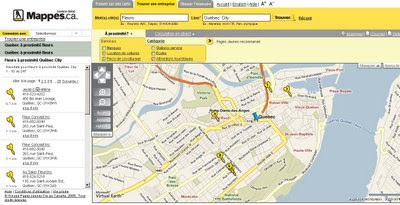
Yellow Pages Canada Maps French (Beta)
Both English and French Languages are supported.

Yellow Pages Canada Maps English (Beta)
Cluster Mapping works very well, clicking on them zooms to the area and icons are shown individually.

The hidden plus is the accessibility of the Text can be increased for users .
  • Use the instructions below to change the font size on Maps.ca: Use the Text Size Increase buttons at the top right-hand side of the page
  • Or You can adjust the text size in your browser. Please consult your specific browser’s help file for specific instructions on adjusting text size.

"Maps.ca Launches Beta Version of Yellow Pages Portal Featuring Microsoft Virtual Earth
Maps.ca has beta launched a new version of its Yellow Pages portal, utilizing Virtual Earth maps and imagery to help customers locate and save business and travel information. The “find on a map” feature uses Virtual Earth AJAX Control’s geocoding capabilities, and provides relevant results for address or place-of-interest queries. By searching through the new site, customers can quickly locate business information, and are provided with driving directions and updates, including Virtual Earth traffic data. In addition, visitors are able to customize maps, selecting and saving locations most pertinent to them for access later."

French Canadian Version http://www.mappes.ca
English Canadian Version http://www.maps.ca

*Note Live Traffic is only available for Toronto currently.

Source:
http://blogs.msdn.com/virtualearth/archive/2008/10/14/maps-ca-yellow-pages-canada-and-virtual-earth.aspx

Labels: , , , , , , ,