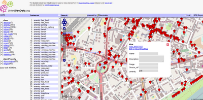
Open Street Map Linked GeoData
Open Street Map Linked GeoData (RDF)
Making geographical data more discoverable and accessible:

LinkedGeoData is an effort to add a spatial dimension to the Web of Data / Semantic Web. LinkedGeoData uses the information collected by the OpenStreetMap project and makes it available as an RDF knowledge base according to the Linked Data principles. It interlinks this data with other knowledge bases in the Linking Open Data initiative.
The Linked Geo Data Knowledge Base
"In order to employ the Web as a medium for data and information integration, comprehensive datasets and vocabularies are required as they enable the disambiguation and alignment of other data and information. Many real-life information integration and aggregation tasks are impossible without comprehensive background knowledge related to spatial features of the ways, structures and landscapes surrounding us."
LinkedGeoData uses the comprehensive OpenStreetMap spatial data collection to create a large spatial knowledge base. It currently consists of information about approx. 350 million nodes and 30 million ways and the resulting RDF data comprises approximately 2 billion triples. The data is available according to the Linked Data principles and interlinked with DBpedia.
Accessing the data:
The following interfaces exist for online access:
- Rest Api: provides basic access to a database with a full Open Street Map (OSM) planet file loaded.
- Sparql Endpoints: enable queries on databases with a reduced (but hopefully for many applications relevant) subset of the whole data loaded. The Sparql Endpoints come in two flavours:
Example Link
http://browser.linkedgeodata.org/?lat=51.063657689874&lon=13.750735172091&zoom=16&prop=amenity&val=
Access to the Data
http://linkedgeodata.org/OnlineAccess
Labels: Accessibility, Linked Geodata, Open Street Map, RDF


0 Comments:
Post a Comment
<< Home