->

11 August 2011

USGS Historical Map Release

USGS Historical Map Release (Coming Soon)

The USGS Historical Quadrangle Scanning Project (HQSP) is scanning all scales and all editions of approximately 250,000 topographic maps published by the U.S. Geological Survey (USGS) since the inception of the topographic mapping program in 1884.

USGS Map Locator
National Map Viewer can locate historical Maps for user to download

Because historical maps are stored in a limited number of collections and are not readily available, the USGS National Geospatial Program has begun a project to convert these historical printed topographic quadrangles to an electronic format (GeoTIFF and GeoPDF®). This project serves the dual purpose of creating a master catalog and digital archive copies of the irreplaceable collection of topographic maps in the USGS Reston Map Library as well as making the maps available for viewing and downloading from theUSGS Store and The National Map Viewer.
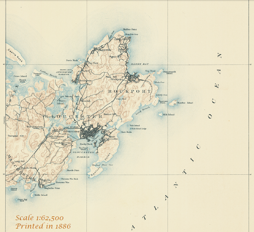
USGS Map 1886
One of the first Maps Created by USGS back in1886 will be available to download.

Source:
http://dracutlibrary.wordpress.com/2011/08/11/historical-maps/

Official PDF on the project
http://pubs.usgs.gov/fs/2011/3009/fs20113009_013111.pdf [PDF]

Link to the National Map Viewer [USGS Store]
http://store.usgs.gov/b2c_usgs/usgs/maplocator/%28ctype=areaDetails&xcm=r3standardpitrex_prd&carea=%24ROOT&layout=6_1_61_48&uiarea=2%29/.do

*Some maps will require a purchase - but most will be free of charge to download in GeoPDF and GeoTiff formats.


Labels: , , , , ,

09 September 2009

New Canadian Toporama WMS service - Examples

New Canadian Toporama WMS service - Examples

update:12/09/2009

Geospatial provides a little more information on ftp access {bulk downloads} to map data.
http://geospatial.blogs.com/geospatial/2009/09/nrcan-wms-service-for-canadian-vector-topo-maps.html


new link:
http://tinyurl.com/nuseox
(newer code)

WMS [Web Mapping Service]
is not new - in GIS and Technology terms is old.
But there are plenty of services, organisations, governments out there that do serve their content via this format.

So why this post - Well there was a Google Maps API Thread that was becoming very interesting:
"mentionned last week that canadian topo maps (NRCAN) are of poor quality. This is true. But a new service have been implemented in may by NRCAN to replace it. It seems this introduction passed unnoticed so far. I myself searched for a long time and to find information about this new service. NRCAN has introduced in may the Toporama WMS service. This gives access to the new CANTOPO, the new generation of Topographic Maps (1 :50,000) produced by NRCAN. Theses maps are in vector format. The availability of this new vector format for canadian topo maps gives us more precision and clarity as compared to the old Raster Maps format who where a scan of the Paper Maps. Texts describing rivers and local points of interest do not anymore collapse when zooming to lower levels. The map is also of higher quality at higher zoom level. And
the information shown on the maps is adapted to the zoom levels. "
PierreB

Then the talented google map api programmer PapaBear picked up on this and quickly developed this:
Canada Vector WMS Maps - Service - Google Map Mashup
the new generation of Topographic Maps from CANTOPO
The quality and content from this dataset is rich in detail, contours, very small lakes, buildings, rail road etc

Though the full credit goes to PapaBear for the example and PierreB for thier knowledge and skills to put this together in a very short space of time.

"This map is of a station (survey marker) very near the border in
Maine. It should open with USGS topo map type. These topos usually
overlap the border and show a short distance into Canada (usually to
the next 7.5 or 15 minutes of longitide, depending on the scale).

The map type is changed with the selector in the upper right. I have
kept the old raster version from NR canada (type "CanRas") as well as
the new vector maps (type "CanVec").

You can compare the USGS topos and the 2 Canadian types for the same
locale. The USGS map tiles are also raster data (and these have been
know to have missing areas and occasional mis-registration) but they
are higher resolution scans than the old NR Canada tiles..

The topography is not too interesting, since it's a swampy area, but
nevertheless the different map type are all visible. "

If you want to see a working example then go to:
http://members.bellatlantic.net/~vze2h6gy/papabear/BM_Station_GMap.html#FILE=Maine_Peaks.js&index=QF1769&title=1&width=960&height=720&showrm=1

{note: this is a testing environment and change be moved or changed without notice}

But hopefully users will be impressed with the resources and hopefully make use of the wms services still out there.

Well done.

Labels: , , , , , , ,

04 September 2009

TopOSM Updates

TopOSM Updates

The 'prettiest' form of Open Street Map has a nice clean update:

TopOSM Colorado
TopOSM has new coverage - Colorado

Permalink - http://toposm.com/co/?zoom=14&lat=40.0303&lon=-105.30387&layers=B0TT

(Links to the map above)

TopOSM Changes:
  • Released TopOSM Colorado
  • Colour-by-elevation in base layer
  • The hillshading, contour lines and map features are on separate layers. Use the layer switcher (top right "+") to toggle.
Techie talk:
"I created a Python script to generate map legend HTML snippets - complete with images - from mapnik description files and a short description file that specify what features to include. You can see the result at http://toposm.com/ma clicking on the "Show/Hide Legend" at the bottom right. Legends are specific to the current zoom level, so they will refresh when zooming in and out."

"I also added elevation labels for contour lines. The only issue is that the data from MassGIS (where the contours come from) is in meters (3 meter interval) and my map is entirely in ft, so the values look a bit funky sometimes. Not much I can do about that, though..."
Lars Ahlzen

Lots of minor other improvements too. There's a full change log at:
http://toposm.com/changelog.html

As always, the map is at http://toposm.com/

Full Credit to Lars Ahlzen in this excellent version of Open Street Map
he notes:
"It took longer than I thought, but I've finally released TopOSM (my OSM-based topographic map project) for the state of Colorado."


Source:
http://www.openstreetmap.org/user/Ahlzen/diary

Previous Posts:
http://mapperz.blogspot.com/2009/04/toposm-pretty-openstreet-map.html

Labels: , , , , , ,