->

30 April 2009

TopOSM [Pretty Open Street Map]

TopOSM [Pretty Open Street Map]

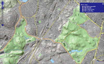
Well done Lars Ahlzen for creating one of the best Open Street Map raster/rendering layers, highly detailed at lower zoom levels and with the mixing of terrain and contours data layers you can clearly surrounding area in 2.5D perspective.
eye in on the details, individual buildings, walking routes visible and good cartographic symbology and text placement.

TopOSM - Open Street Map
Clear, defined cartographic rendering is TopOSM.
Hopefully the OpenStreetMap see's this and acknowledges your efforts.

Map by Lars Ahlzen. CC-BY-SA. Data from OpenStreetMap and Office of Geographic and Environmental Information (MassGIS), Commonwealth of Massachusetts Executive Office of Environmental Affairs.

View the TopOSM Map
http://toposm.com/ma/?zoom=15&lat=42.30382&lon=-71.11249&layers=B000

Mapperz

Labels: , , , ,

29 April 2009

A to Z London 1930's Map Online [Slippy Map]

A to Z London 1930's Map Online [Slippy Map]

A to Z London 1930s
A to Z have put the original 'A to Z' 1930's London Map online using Openlayers and Mapserver

"Discover the streets of a bygone age with a nostalgic look back in time at this early edition of the famous London A-Z."

View an extract taken from the 1930's London map


"The original printing of this paperback street atlas before the Second World War was in black only; however, this facsimile reproduction has been printed in colours which simulate the current condition after its ageing over many years."

"Geographers' Map Company was founded in 1936 by Phyllis Pearsall MBE (1906-1996) who, encouraged by her father Alexander Gross, took on the ambitious task of publishing up-to-date street mapping of London. This Historical Edition is a facsimile reproduction of one of her first publications featuring the now renowned A to Z logo on the front cover."

London Street Atlas - Historical Edition is available in paper form
http://www.a-zmaps.co.uk/?nid=60&iid=3554

Labels: , , , , , ,

27 April 2009

Microsoft 'Static' Birds Eye View [Staging Preview]

Microsoft 'Static' Birds Eye View [Staging Preview]

Virtual Earth April 2009 update:

"This release is a mere 9+ TB of data; however, it covers over 1 million square kilometers of Earth"

http://blogs.msdn.com/virtualearth/archive/2009/04/28/virtual-earth-imagery-release-april-2009.aspx


The Microsoft Virtual Earth Web Service SDK now allows you to access images in a static way

The are advantages to this including:
  • Creating seamless 'stitched' images
  • Generation for mobile devices (non-javascript or flash based)
  • Inserting into documents

Birds Eye View - Static


Getting Static Birds eye Images Using Microsoft's Virtual Earth Web Service

try it here
http://cp.cloudapp.net/GetBirdsEyeImage.aspx

Search Birds Eye View Static
courtesy of Chris Pendleton

Also available for road, aerial, hybrid tiles for use in desktop and mobile access.
see
http://blogs.msdn.com/virtualearth/archive/2009/04/23/rendering-static-virtual-earth-bird-s-eye-images.aspx
for more information

Labels: , , , , ,

24 April 2009

London Marathon Maps 2009

London Marathon Map 2009

Racing starts 9.00am BST on Sunday 26th April 2009

9am Elite Women's Race Starts
9.25am Wheelchairs Race Starts
9.45am Elite Men's Race Starts
9.45am Mass Starts

BBC Sport London Marathon Map 2009 - Virtual Earth
BBC using Virtual Earth - No Route. and have some issues with the users in the US not centering on London. (Overlay a KML file would provide a route)
http://news.bbc.co.uk/sport1/hi/athletics/8011891.stm

How 'live' is this map? [Race starts 9.00am BST on Sunday 26th April 2009]

New content is added to the map as soon as it becomes available - in many cases there is a short delay involved, as video, audio and images must be received and edited before being published.

But it looks like nothing had changed.

You need to refresh the page to see updates. Some points on the map, for example image galleries, update with fresh content as the marathon progresses. In other cases, older content is removed from the map and replaced by newer content from a similar area.

It would have been useful to see the full marathon route on this map.

We agree. This was not possible this year, but we expect to offer this in future.

Overlay a KML file would work.

For a Route Map see the Guardian
http://www.guardian.co.uk/lifeandstyle/interactive/2009/apr/22/london-marathon-route-map and click 'Runner'
Guardian London Marathon Route Map 2009
Image from The Guardian

Route Planner
http://www.realbuzz.com/flmroutes/map.html
links from the Official Site - http://www.london-marathon.co.uk/site/
(not the best - needs updating from last year)


View Larger Map
This route might incorrect as it is from an old source (2005) but took 0.22 seconds to find

Labels: , , , , , ,

23 April 2009

Google My Maps Directions [Save & Share]

Google My Maps Directions [Save & Share]


It is now possible to create your own custom directions in My Maps.
Snapping fixes itself to the centreline of the teleatlas data.

This can then be saved and shared to anyone.
Edit and customise your own routes.

Source:

Official Blog [Google LatLong]

Labels: , , , , ,

140,000 miles of African Roads into OpenStreetMap

140,000 miles of African Roads into OpenStreetMap (more to come too)

OpenStreetMap[Africa] is having a huge boost of data from http://www.africover.org/

"We just finished uploading 141,107.17 miles (67 MB) of road data for Congo DRC, Tanzania, Sudan, Kenya, Burundi, and Rwanda"

"OSM will play a crucial role in some of our upcoming mapping projects and these additions make significant improvements to the coverage, especially in rural areas. The data should go live sometime in the next several days. Here is a look at the country maps, before and after this work."


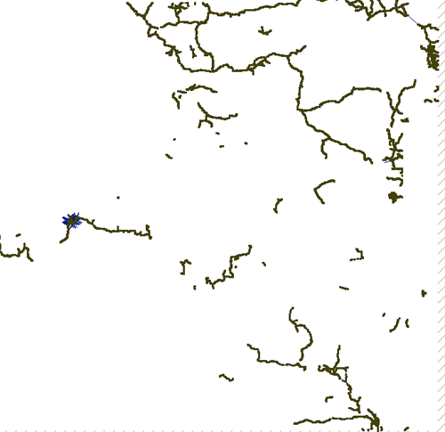
Congo DRC before
Congo DRC before


Congo DRC After
Congo DRC After

Image sources: http://www.developmentseed.org

As shown above, they have imported new street data for six countries.
Thanks to Africover and DEPHA, they have street layers for five other countries and will be adding them to OSM in the coming weeks.

Keep and eye on
http://www.openstreetmap.org/?lat=7.4&lon=15.7&zoom=3&layers=B000FTF
(available in a few days time) - Zoom in and see the huge amount of difference this will make.

For more thanks and detailed stats and images on this please visit
http://www.developmentseed.org/blog/2009/apr/22/thousands_of_miles_added_open_street_map

How Geospatial should be made available everywhere in the world.
Mapperz

OSM data related:
http://mapperz.blogspot.com/2008/02/tiger-tiger-openstreetmap.html
real-time updates on #osm (twitter)

Labels: , , , , , ,

20 April 2009

Via Michelin Revamp (Maps, Routes & Photo's)

Via Michelin Revamp (Maps, Routes & Photo's)

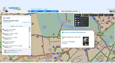
Via Michelin Maps Revamp - Points of Interest
Lot of new content availble in Via Michelin Maps - Speed Cameras, Traffic Incidents, Parking and Weather available across Europe.

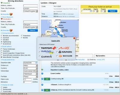
Via Michelin Maps Revamp - Routing
Full routing (Directions) right across Europe - France to Turkey in this case.

Via Michelin Send to GPS
GPS users can send themselves routes (directions) six different types are supported.
Note the good selection of alternative routes - sightseeing, economical quickest, shortest, pedestrian and bike.
Different types of automobiles (with caravan etc) and fuel cost calculator.
Display Hotels, Restaurant and Tourist site on-route.

Very impressive revamp from Via Michelin - the more you look the more there is with this site.

Via Michelin PhotoExplorer Labs (beta)
PhotoExplorer is currently in Labs (beta) with Via Michelin but looks familiar to the panorama layer google maps has (but it is Via Michelin own content).
more labs products:
http://labs.viamichelin.com/


Via Michelin is available in many more languages (Click the Flag Icon at anytime)
Native is French - http://www.viamichelin.fr/viamichelin/fra/tpl/hme/MaHomePage.htm

Labels: , , , , , ,

19 April 2009

The Times: Best walks in the British Isles with Maps

The Times: Best walks in the British Isles with Maps
The Times are promoting the best of British walks with the use of custom made route maps and Google maps.
The Routes are also available for Mobile Phones:
http://timesmobile.mobi/walks

Here are the 20 Walks in PDF Format

All have Blister Ratings, Pub Ratings and View Ratings.

1. Alfriston - Seven Sisters, East Sussex, by Alan Franks
2. Oxford - Wolvercote circular by Libby Purves
3. Branscombe to Beer, Devon, by Monty Halls
4. Land's End to Nanjizal by Alex Wade
5. Withypool, Exmoor, Somerset by Alice Thomson
6. Porlock Weir to Culbone Church, Exmoor, Somerset by Joe Swift (Porlock Weir spelling is wrong on the pdf)
7. Oxwich Bay, Gower Peninsula, Wales by Kate Humble
8. Brecon Beacons Horseshoe, Wales, by Damian Whitworth
9. Snowdon via the Pyg Track, Wales by David Aaronovitch
10. Malham Cove , Yorkshire Dales by Matthew Hoggard
11. Muker-Keld, Yorkshire Dales by Ann Treneman
12. Seathwaite - Scafell Pike, Lake District by Giles Whittell
13. Ullswater, Lake District by Hunter Davies
14. Arthur's Seat, Edinburgh by Hugo Rifkind
15. Skipness-Claonaig, the Kintyre Way, Scotland by Ben Macintyre
16. Sileve Binnian, Mourne Mountains, Northern Ireland by David Sharrock
17. Chew Green, Northumberland by Christopher Somerville
18. Blythburgh - Eastbridge, Suffolk by Simon Barnes
19. Wells-next-the-Sea to Cley, Norfolk by Richard Morrison
20. The New River and the Lee, Hertfordshire by Derwent May

**There seems to be a copyright acknowledgment issue here - some pdf's reveal that there is Ordnance Survey 1:50,000 rasters underneath the 'walking route maps' but there is no crown copyright acknowledgment on the map or pdf's. Hope the Times realize this is breaking crown copyright.
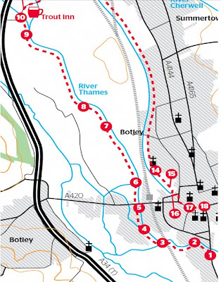
2 Botleys no Oxford
Two Botleys on the - map confusion - No Oxford? - Summertown sliced off and where are the toilets? No Scale? No copyright**? [image for illustration only]

Cartographically these maps are not the best - the editors missed the importance of Toilets on the routes and there are various spelling mistakes and label mis-placement but they do guide you for their purpose.

They do also presume you have the relevant Ordnance Survey Explorer Maps [1:25,000].
These can be viewed from Multimap [OS Map mode] and Where is the Path for free.

Labels: , , , , , ,

16 April 2009

Google Maps Adds Web Cam Layer - New!

Google Maps Adds Web Cam Layer - New!

Google Maps Web Cam Layer
Live Web Cams within Google Maps as a new layer in the 'More' tab.
Click the thumbnail images to view a live webcam - local time zones apply.

Labels: , , , ,

OpenStreetMap Going READ-ONLY* [upgrade]

OpenStreetMap Going READ-ONLY* [upgrade]
*for 2 days

This is now active...
http://www.openstreetmap.org/offline

"The OpenStreetMap database is currently in read-only mode while essential database maintenance work is carried out. "

Note: GPX Upload will also be unavailable.


Why can't I edit OpenStreetMap from tomorrow 10am British Summer Time?

OSM is Due Downtime for Upgrading - Read Only Mode
Due to major upgrading OpenStreetMap will say 'no' to editing.


This is due to a Major Upgrade of Hardware/API Software and many other components too much to list out.

OpenStreetMap API 0.6 is scheduled to go live on 17-19th April, 2009.

"Expect server downtime during that period. The current API will go into Read Only mode at 10:00am BST (9:00 UTC) Friday 17th April. You might need to upgrade your editor to use the new API after the work is complete. There may also be some hiccups in the following days."

http://wiki.openstreetmap.org/wiki/OSM_Protocol_Version_0.6/Information

Why so much downtime?

"Switching off" OSM for up to four days isn't something we take lightly, but we don't have much choice. We're moving the data from one database server to our shiny new one. Also there's a lot of processing to create changesets, fix utf8 bugs, deal with inconsistencies and stuff.

We will keep the API up and running in read-only mode for most of the weekend, and the website displaying maps, however we will need at least a short period of total downtime.

If you are a JOSM user, you will be able to download but not upload over much of the weekend, however you would be well advised to upload any mapping work before the weekend, and dont start any extensive editing work until you're up and running with API0.6 next week. Compatibility glitches are a possibility otherwise.

http://wiki.openstreetmap.org/wiki/OSM_Protocol_Version_0.6/Information#Why_so_much_downtime.3F

Mapperz hopes the upgrading goes smoothly and painlessly as possible. Good luck with the upgrade OSM team.
Afterwards you will find OpenStreetMap at a faster pace for an even more enjoyable mapping experience.

Labels: , , , , , ,

14 April 2009

Dual Maps Version 3

Dual Maps Version 3


Panda watching cricket - Dual maps Version 3
Features:
  • Dual maps combine Google Maps, Google Street View and Microsoft Virtual Earth into one embeddable control.
  • Free to use, no registration required.
  • Many customizable settings
  • New: View Google Search results in Street View (where available)
  • New: Option to supply an address instead of co-ordinates to generate a Dual Map.
  • New: Choose your street view icon:
    Car

    Peg Man

    Leprechaun

    Panda

    Gachapeg

Labels: , , , ,

13 April 2009

Super Heatwave in April? [BBC Weather Map]

Super Heatwave in April? [BBC Weather Map]


Super Heatwave - BBC Weather Error

According to BBC Weather there is a SuperHeatwave [36+ degrees] in the North of England at 12 noon today.

When data feeds go wrong?


The Met Office [Offical UK source] has a more normal prediction
Met Office - Normal Prediction
http://www.metoffice.gov.uk/weather/uk/uk_forecast_temp.html


Surprisingly it looks like and error on the BBC Weather side as they use Met Office data.

Labels: , , , ,

10 April 2009

Google Maps Mobile [version 3.0.1.4]

Google Maps Mobile [version 3.0.1.4]

Google Maps Mobile version 3.0.1.4
A minor update but with a few changes.

Most noticable when you search the result animate [drop in markers] to the area.

New Users to Google Maps Mobile can have the following in thier pocket:

Public Transport
Public Transport - can change times starting off.

Send as SMS - Text Message
Meeting a friend? You can send them the map where to meet.

Walking Directions Beta
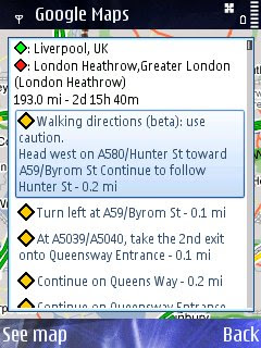
Walking Direction improved - Not really walking Liverpool to London Heatherow but just a good test - seems faster to calculate in prevoius versions.

Street View Mobile with route
StreetView Mobile - again seems much quicker and also displays your route [pegman guides you].

Available via - http://www.google.com/mobile/


Source:
http://www.allaboutsymbian.com/news/item/9286_Google_Maps_for_Symbian_update.php


Labels: , , , , ,

09 April 2009

AA Real Time Speed Map England, Scotland & Wales

AA Real Time Speed Map England, Scotland & Wales

AA Real Time Speed Map
Real-time** Speed Mapped on Major Roads and Motorways in England, Scotland and Wales

**10 minutes out approximately

Though when try to zoom out it becomes a little heavy for the Web Browser

The Automobile Association [AA] developers might want to invest a little time investigating Cluster Markers.

Server-Sided Cluster Markers
http://maps.forum.nu/server_side_clusterer/

Javascript Cluster Markers
http://econym.org.uk/gmap/clusterer.htm [monitors the map movements ]

http://googlemapsapi.martinpearman.co.uk/readarticle.php?article_id=1

See the Real-Time Speed Map
http://www.theaa.com/traffic-news/index.jsp

Related Previous Posts
http://mapperz.blogspot.com/2008/11/new-aa-route-planner-beta.html

Labels: , , , ,

08 April 2009

Super Lightweight Spatial Database [SpatiaLite]

Superlight Spatial Database [SpatiaLite]

After a quick review of 'Free' Open Source GIS software. Had a look at Spatial Databases
There is a SpatiaLite - and it's easy to use 1,2,3 Go! (five minute guide)

What can you do quickly?
MBR [Minimum Bounding Rectangle] Example

What is an MBR? Above graphically shows the Bottom Left and Top Right of a rectangle using this as an extent to find spatial features within.This is one of the most basic ways to find something spatially.
More on MBR [Minimum Bounding Rectangle] Function [Wiki]

Spatialite MBR SQL Function
SQL request to find all features within the MBR

*Data used was OpenStreetMap in shapefile format
Not saying this is best spatial database out there but is certain to be the quickest to download,install and load data within it.

Features:
* Enhanced GUI tool v1.2
* SQL mathematical functions
* EXIF-GPS geometry-handling functions
* Virtual Table module VirtualNetwork
* Supporting routing [Dijkstra's Shortest Path algorithm]
* Supports importing and exporting to shapefiles [big plus]
* Supports standard WKT and WKB formats

Tutorials and Documentation to get you started.
http://www.gaia-gis.it/spatialite/docs.html

Why Super Lightweight? [8.3mb windows application] that's why.

Related links:
http://www.gaia-gis.it/spatialite/ [Main Homepage]
http://groups.google.com/group/spatialite-users?pli=1 [Google Group - Spatialite]

http://mapperz.blogspot.com/2008/09/open-street-map-in-shapefile-format.html
http://www.geofabrik.de/data/download.html [Open Street Map data in shapefiles]

Downloads
http://www.gaia-gis.it/spatialite/binaries.html [Applications for Mac,Windows,Linux]
http://www.gaia-gis.it/spatialite/resources.html [Sample Databases, Routing, Test Scripts]

Mapperz

Labels: , , , , , ,

07 April 2009

OpenJump GIS

OpenJump GIS [Free Java based GIS]

update 21/04/2009

OpenJump 1.3 (more GIS analysis, faster, better)

http://www.openjump.org/wiki/show/New+OpenJUMP+Release
source: SlashGeo

There are more and more Open Source Projects coming along though which is the better of the bunch?
Not saying this is the 'best' though users are different to the developers.
OpenJump GIS is one of the better all round 'Free GIS' programs because:
  1. It supports common GIS formats (.shp, .tif, .gml etc).
  2. You can EDIT the data - lots are free but this one you can fully edit the data.
  3. You can do some GIS Analysis!
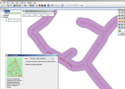
OpenJumpGIS - Buffering
Buffering for Free, OpenJump does do plenty of spatial analysis.

Spatial Analysis built-in (no plugins required!)
  • Intersect, Buffer, Union, Symmetrical Differences, Centroid
  • Generalisation
  • Polygonise (converts lines to polygons)
  • Join attributes by spatial location
  • Thiessen Polygon Creation
  • Attribution Queries
Additonal 'Plug-ins' can be loaded - though it's best the download them separately and unzip them on you computer the folder.

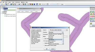
OpenJumpGIS - Geometry Functions
More Geometry Functions: Line Merge

More information on Open Jump

http://openjump.org/wiki/show/OpenJUMP


Future Suggestions? - More of the same, this is great for students and non-commercial, non profit organisations with limited budgets.
Maybe a Print View/Layout function if need to print
Support for (.osm and .gpx for OpenStreetMap) would be very helpful to many 'map makers'

OpenJump can also export to common formats (.gml, .wkt, .shp and postgis tables)

via SlashGeo
We mentioned other open source GIS software such as Quantum GIS, GRASS GIS, uDig and gvSIG amongst others.

Labels: , , , , , ,

03 April 2009

Grand National Map 2009 [Racecourse]

Grand National Map 2009 [Racecourse]

Grand National Mapped - 2009
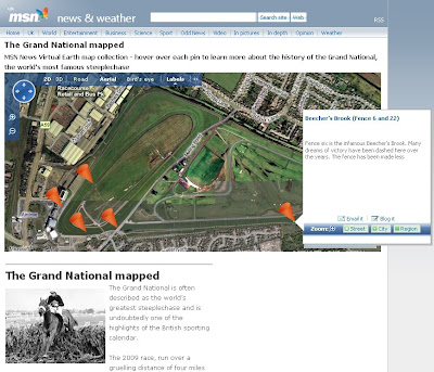
For the lead up to the 'Greatest' Steeplechase in the World - Via MSN [Virtual Earth]

"The 2009 race, run over a gruelling distance of four miles and four furlongs, takes place on April 4 with a field of around 40 thoroughbreds hoping to navigate 30 of Aintree’s famous fences and secure victory.

MSN News presents an interactive map of Aintree Racecourse featuring the famous fences and landmarks where the historic steeplechase has been won and lost.

Use the cursors to navigate your way around Aintree and utilise bird's eye view for a close up look at each key Grand National location."

http://news.uk.msn.com/media/map/
grand-national.aspx?cp-documentid=15355089

Grand National Moments
http://news.uk.msn.com/in-pictures/gallery.aspx?cp-documentid=15354822

Bird's Eye View available
http://maps.live.com/default.aspx?v=2&FORM=LMLTCP&cp=sxc8dygrp54n&style=b&lvl=1&tilt=-90&dir=0&alt=-1000&scene=29150710&phx=0&phy=0&phscl=1&encType=1

Labels: , , , ,

02 April 2009

Google Maps Map Maker [Vector Data]

Google Maps Map Maker [Vector Data]

update: more screen shots and discussion on Map Maker vs OpenStreetMap data
http://brainoff.com/weblog/2009/04/01/1391

***FOR NON COMMERCIAL USE***

Google are now allowing you to download the vector data (Kenya only so far) in either Keyhole Markup Language (KML) or in ESRI Shapefile format.

Google are now returning the favour of Map Makers who have contributed to Google Map Maker

The idea of Google using users to map areas of the World where the likes of TeleAtlas Data is limited or non existent has been rewarding to both Google (gaining mapping content) and NOW non-commercial-non-profit entities.


View Larger Map
Google Map Maker- Kenya Vector in ArcMap
Screenshot of the Vector Data in ArcMap - Same data as above just different style applied.

View this as a layered/attributed PDF [will request to download or view] -1mb

***FOR NON COMMERCIAL USE***

Mapperz had a speedy look at this.

and loaded the shapefiles into a Geodatabase (topology can be cleaned and edited in ArcMap).

Created a quick Cartographic Representation and did a very quick style.

The Result is quite different to the Google Maps Style of Mapping (on purpose). But the underlining data is the same.
(no editing was done to the downloaded data - only shapefile to file geodatabase was done.)

Future: Does this step on the toes to projects like OSM? yes and no - can see both working.
Analysis -
There are many aspects of this vector data that can be applied - buffering, spatial searches and geocoding for starters...

Google Map Maker Kenya Vector Data Styled reloaded into Google Earth
The Exported 'Styled' Data from ArcMap (MapDoc to KML export) in Google Earth
Note: There are better KML/KMZ exporters than the standard ArcMap one

http://mapperz.kml.googlepages.com/Google_MapMaker_Vector_Kenya.kmz

(best loaded into Google Earth - file too big for Google Maps/API)

The Data is available after accepting the terms here
https://services.google.com/fb/forms/mapmakerdatadownload/

Thanks to Mano Marks via Twitter

Mapperz

Labels: , , , , ,

01 April 2009

Live Maps - BBC G20 Summit Map

Live Maps - BBC G20 Summit Map

BBC G20 Summit Map

More live reporting and mapping the activities surrounding the G20 Summit from the BBC.

"Use this live map to follow the G20 summit by exploring London in video, audio, pictures and text."

"Updates will appear on this map throughout the summit, tracking both the G20 itself and the protests expected to accompany it.

When first loaded, the map's focus falls on the City, where demonstrations are expected on Wednesday.

Scroll right to view developments at the Excel Centre in London's Royal Docks area, which hosts the summit on Thursday, 2 April, and zoom out to explore farther afield."
source: http://news.bbc.co.uk/1/hi/uk/7975220.stm

Feedback form for the map
http://news.bbc.co.uk/1/hi/talking_point/7976215.stm

Using the Virtual Earth SDK [Live Maps]


Labels: , , , ,