->

13 September 2011

GIS Stack Exchange Blog (New)

The GIS Stack Exchange Community now has a GIS Blog for interesting topics and expansion of questions and events from http://gis.stackexchange.com/questions

If you are interested in GIS, Cartography,Web Mapping, Databases you can also join in and expand the knowledge sharing that answers questions quickly.

http://gis.blogoverflow.com/

GIS Community Blog


Welcome to the New GIS Blog Overflow, a new additional to GIS Stack Exchange Community

New content will be coming soon from community members from the GIS Stack Exchange.

Popular & reoccurring topics on GIS.SE, events related to GIS and the GIS.SE community with a random collection of posts by different authors will give a good wide cross-section of articles.

  • Popular questions will be also expanded.
  • Commercial and Open Source related GIS posts (includes beta software) are welcomed.
  • Community GIS News and Events will also be included

Potential Blog Author?

If you have a post that you would like to be included please contact the moderator (Mapperz or mapperz@gmail.com) by leaving a comment on this blog post.

Many thanks to the community users input who have made this blog possible

Labels: , , , ,

18 January 2011

FME 2011 - Released

FME 2011 - Released

FME 2011 release today

"Probably the best Feature Manipulation Engine [FME] GIS/CAD conversion software you can get."

FME 2011 - Released

FME 2011 release "story through some numbers"

Top Pick from Mapperz #osm data reader and writer!

  • 25,000: Approximate number of CPU hours spent on the automated testing of FME 2011
  • 8320: Number of automated tests run each weekend
  • 8304: Number of source code check-ins on the FME 2011 code tree
  • 6249: Number of automated tests run on each daily FME build
  • 2602: Number of documented development tasks closed during FME 2011
  • 1008: Number of in-person attendees at FME User Meetings during calendar 2010
  • 592: Number of unique customer requests resolved with FME 2011
  • 416: Number of transformers shipped with FME 2011
  • 265: Number of formats supported by FME 2011
  • 201: Number of builds of FME 2011 that have been made (so far)
  • 20: Number of hours of CPU a complete test run takes on the fastest platform
  • 15: Number of months that we’ve been actively developing on FME 2011
  • 11: Average percentage speedup of FME 2011 vs. FME 2010 across all tests which run for more than 7 seconds
  • 5: Number of platforms the above tests are run on
  • 1: FME 2011 Gold master DVD shipped off to the press

"All these numbers add up to what we believe is the highest quality, most powerful, and most usable FME ever."

Driven by User Feedback
FME have been able to implement so many excellent suggestions from users (many of which we received during our user meetings throughout the year) – including:

    a) Ability to work with LiDAR and point cloud data
    b) Templates to get you started down the right path
    c) Convenient SQL Querying
    d) Scheduling and a REST API for FME Server
    e) A greatly expanded set of Tester predicates
    f) Inline data inspection – “workspace debugging” if you like. No more waiting for a translation to finish to see what the results are
    g) “Styler” transformers for customizing CAD output
    h) More powerful XML support
    i) Support for cloud options (Windows Azure, Google Spreadsheet, etc)

http://blog.safe.com/2011/01/fme-2011-a-retrospective-on-todays-release/

Labels: , , , , ,

30 July 2010

GIS Stack Exchange is Open to All

 GIS Stack Exchange is Open to All - New!

A place where you can post a question and get fast answers.
Wiki cross Digg approach. Using Tags and forum based content.
Any 'geo' question

What kind of questions can I ask here?

GIS Stack Exchange Answering GIS Questions 


from the FAQ:
GIS - Stack Exchange is for programmers, DBAs, Cartographers, Geographers and anyone interested in GIS professionally.
Please do look around to see if your question has already been asked (and maybe even answered!) before you ask.

What kind of questions should I not ask here?

Avoid asking questions that are subjective, argumentative, or require extended discussion. This is not a discussion board, this is a place for questions that can be answered!
If you want to talk about the site itself, please don't do it here. Visit the meta-discussion site where you can talk about things like what questions are appropriate, what tags we should use, suggest a feature, or generally discuss how GIS - Stack Exchange  works.

Be nice.

Treat others with the same respect you'd want them to treat you. We're all here to learn together. Be tolerant of others who may not know everything you know. Bring your sense of humor.

Be honest.

Above all, be honest. If you see misinformation, vote it down. Insert comments indicating what, specifically, is wrong. Even better — edit and improve the information! Provide stronger, faster, superior answers of your own!

Full FAQ

Interested? then sign up
http://gis.stackexchange.com/

Created by http://area51.stackexchange.com/

Labels: , , , , ,

05 November 2009

OpenStreetMap Data 'On Demand' with Quantum GIS 'Mimas'

OpenStreetMap Data 'On Demand' with Quantum GIS 'Mimas'

Updated 07/11/2009

Getting the data you want.

One of the hardest things about OpenStreetMap [#OSM] is getting access to the data you want and for the location you require.
You can download large files for entire regions or countries, but why only if your going to use a small amount.

CloudMade gives you this by country. http://downloads.cloudmade.com/

Here is a solution - All software is FREE and Open Source so no excuses.

OSM direct access within Quantum and saved in Postgres
Viewing styled (Automatically) Open Street Map Data in Quantum GIS 'Mimas' [QGIS]
The data has been downloaded directly from the Open Street Map Servers [most up to date data].
**There are area limitions controlled by OpenStreetMap Servers, the plugin will warn you of this issue if required.
You also can edit, select features, query features and do spatial geoprocessing (buffer,intersect etc) on the data.

Clarification on editing the OSM data.

After selecting the area, download to a location on your computer .osm format.
you will get 3 layers called
osm points*
osm lines*
osm polygons*
*not editable
now these are 'representations' only, so you are required to load the .osm file in again.
use the openstreetmap plugin to do this
This will create two layers ways and nodes - These can be edited - right click/toggle editing.
Now you can edit your OpenStreetMap data.

Import Issues to Edit your on-demand openstreetmap data.

Please note: There are 2 'OpenStreetMap' Plugins available - both are required. But to use the editor with the data downloaded please use the 'Import OpenStreetMap' version - not the Load OSM option.


You will need the development version of Quantum GIS 'Mimas'

http://blog.qgis.org/node/138
http://qgis.org/en/download/current-software.html
http://download.osgeo.org/qgis/win32/QGIS-1.3.0-3-No-GrassSetup.exe [Direct link to Windows file 28.1mb]

Spatial Database or Shapefile?
If you want to store your OSM data and use it for other projects then storing it in a Postgres Spatial Database is a good idea.
http://www.postgresql.org/download/

With Postgis 1.4 (1.5 in dev) you can speed up functions of geoprocessing and achieve more accurate results.
Download - http://postgis.refractions.net/download/ [install after Postgres].

Or if you just want it as a common file type you can just save out to shapefile.
Good if you want to share it to others with minimum impact.

Note: There are many new plugins for Quantum GIS

QGIS plugin manager
For this please use the OpenStreetMap Plugin (Version 0.5) [top]
and if you choose the postgres/postgis route a very useful plugin 'PostGIS manager (Version 0.5.4)' gives users a Graphical User Interface for managing Postgres/Postgis functions.
*versions maybe different in future.

This give users the power and speed. This gives Quantum GIS the edge on Open Source and Commercial GIS by breaking down the limitations and access to geographical data directly.

Labels: , , , , , , , ,

01 September 2009

Portable GIS v2 Released

Portable GIS v2 Released

"Mobile GIS in your pocket - all you need on one USB Stick - *Portable GIS v2"
*mapperz recommends

Portable GIS v2 Suite

If you want a fully featured GIS suite that works portably from a USB stick in Windows, that can be rapidly deployed and used anywhere in the world, and comes with full setup and support, then this is for you.

Key Advantages:

  • Work remotely in the field, and synchronise your data when you return to the office.
  • Rapidly deploy pre-configured GIS data and software packages.
  • Showcase your work at conferences, seminars and presentations.
  • No licensing issues, no matter how many copies you deploy.


Portable GIS V2 - Control Panel
The new Portbable GIS v2 Control Panel


Installing Portable GIS v2 (on USB Stick)
Easy installing - and your be up and running in minutes.


What goes on the USB Stick (2GB stick required)

Included software (with versions)
uDig (1.1.1)
GvSIG (1.1.2)
Quantum GIS (1.02)
PostgreSQL (8.4.01)
PostGIS (1.4.0)
Xampplite: PHP, MySQL, Apache (1.6.2)
Geoserver (1.7.6)
FWTools: ogr, gdal, python, mapserver, openEV (2.4.2)
Tilecache (2.10)
Featureserver (1.12)
PgAdmin III (1.10)
OpenLayers (2.8)

The following utilities are also included:
SqlSync (cross-platform database synchronisation)
GeoMetadataExtractor (extracts metadata from georeferenced images)
Shp2Text (converts shapefiles into csv, with coordinate columns)
Ogr2Gui (GUI for OGR toolkit)
ShapeChecker (Checks and fixes corrupt shape files)


Desktop Modules - Portable GIS
Control Panel give users fast access to Setting Up, Desktop and Web Modules

Full Credit to archaeogeek who has made this make GIS much more portable and easier to use for all levels of GIS knowledge. Well done and many thanks.

Source:
http://www.archaeogeek.com/blog/2009/09/01/portable-gis-version-2-released/

additonal links:
http://oadigital.net/software/pge


Labels: , , , , , , ,

18 May 2009

+30 Top Mapping Blogs (Mapperz=7th?)

+30 Top Mapping Blogs">+30 Top Mapping Blogs (Mapperz=7th?)

Another debatable chart to comment on:

(All these blogs should be number 1.)

According to
http://www.whatsyourplace.de

"Selling the world parcel-wise on Google Maps and being an officially featured project on Google code, we closely follow new developments in the rapidly expanding market of Maps Mashups and the use of digital maps in general. Fortunately, there is a number of great blogs focussing on mapping issues. We would like to share our list of what we consider the top blogs on maps. The top ranking is in accordance with the number of google reader feed subscribers (shown in brackets) at the point of writing this post."

  1. StrangeMaps (13.576) - taking a humerous approach to map depictions - recommended: WW II - if maps could fight
  2. Google LatLong (5.350) - official blog edited by the Google Maps and Google Earth team - recommended: Whale Spotting on Google Earth
  3. Google Earth Blog (3631) - unofficial blog on everything Google Earth - recommended : 3 D Buildings Layer Update
  4. Ogle Earth (3448) - on how Google Earth and related products affect geopolitics - recommended: Exploring Shanghai’s recent geographic history
  5. Google Maps Mania (2915) - mostly edited by GMaps developer Keir Clarke focussing on maps mashups - recommended: Big Art Project on Google Maps
  6. The Map Room (2678) - map blog targeting wider audience - recommended: Is GPS accuracy at risk?
  7. *Mapperz (2131 >2,145 now) - introduces new digital maps - recommended: Africa in Open Street Map, lots of miles * (Still debatable on this - Mapperz)
  8. Spatially Adjusted (2067) - fairly technical GIS blog by professional James Fee - recommended: Licensing issues on the Geoweb
  9. Google Geo Developers (1924) - official blog - recommended: Solution to too many markers problem
  10. AllPointsBlog (1.290) - professional and high-frequency source on location technology. Recommended: Did Navteq really launch a rival to Google Maps?

  11. Free Geography Tools (951) - recommended: Google Maps Route Creation with NetKvik
  12. Virtual Earth (837) - An Evangelist’s Blog - recommended: MSN City Guides Relaunches
  13. GISLounge (656) - GIS information portal - recommended: Finding Bin Laden
  14. Very Spatial (565) - recommended: Digital Cities Concept
  15. Thematic Mapping (379) - focus on maps and economic/political development issues - recommended: Using KML at Thematic Mapping
  16. Programmable Web (34) -tremendous resource and catalogue of API-based mashups - recommended: WhatsYourPlace
  17. The Map Scroll (284) - nontechnological maps-blog - recommended: Taliban Influence in Pakistan
  18. Digital Earth (262) - personal blog focussing mostly on new developments in Microsoft’s and Google’s digital maps products - recommended Google Earth Imagery Update May
  19. Paul Ramsey’s GeoTips (259) - Founding Member of the Open Source Geospatial Foundation - recommended: Web Mapping Architecture at OpenGEO
  20. GeoThought (211) - blog on location technology by industry expert Peter Betty - recommended: The GeoSpatial Technology Revolution (Keynote)
  21. The Electoral Map (207) - focussing on the “intersection between politics and geography” - recommended: 2008 in political geography
  22. ManDown (176) - technical perspective on GIS, ESRI in particular - recommended: arcGIS Mobile 9.4 - Whats next?
  23. CartoTalk (122) - more a forum than a blog, but great place to follow qualified geo-discussions
  24. WebMapper (211) - focussing on the latest trends in location based services - recommended: UK Crime Maps scrutinized
  25. Spatiallaw (102) - low-frequency blog focussing on intersection of legal issues and spatial technologies - recommended: Why Spatial Law?
  26. What is Special About Geospatial (67) - Geo-student blogging about the geoweb - recommended: introduction of Pixelcase, where Photography meets Geoinformation
  27. Google Maps Gone Wild (60) - Examples about things one can do with Google Maps - recommended: recursive queries in Google Maps
  28. Mibazaar (57) - introduces practical Google Maps Mashups - Swine Flu Tweets on Google Maps
  29. atlas(t) (52) - recommended: Shoe Map
  30. WhatsYourPlace (19) - Google Maps Mashup Selling the World - recommended: Obamas Road to Presidency
  31. Geo2Web (16) - GIS technology blog - recommended: Mapping the Death Penalty
  32. Maps and Earth (4) - recommended: Find Custom Maps
source:
http://www.whatsyourplace.de/blog/?p=607#more-607

Labels: , , , , ,

01 May 2009

ArcGIS 9.3.1 - GIS Data Portal - Share Geospatial Data

ArcGIS 9.3.1 - GIS Data Portal - Share Geospatial Data

ArcGIS 9.3.1 - GIS Data Portal
Find available datasets with the new ArcGIS 9.3.1 - GIS Data Portal

Version: 9.3.1.25

Features of the GIS Portal Toolkit Include:

Data Categories:
Web pages that help you discover and access a wide variety of geographic information for a particular data theme or data community.

Current Event or Application Topics:
Web pages that help you discover and access a wide variety of geographic information for a special application area or current event.

Search Page:
The Search page enables you to discover and access a wide variety of geographic information within the GIS Portal Toolkit. This geographic information, provided by government, commercial, and non-commercial organizations, includes map images, map services, geographic datasets, geographic activities, spatial solutions, clearinghouses, and land references.

Performing a Search:
To find content, you can set a search area by place name or you can use the Map Viewer to define your search. Once your search area is established, you can set your search criteria based on content type, such as map service, geographic datasets, activities, etc., data theme, keywords or date ranges. The results of the search are displayed along with metadata and if appropriate a map.

View Metadata:
You can use the metadata detail and the full metadata view to browse through information to locate what you are looking for. Map data can be viewed in the Map Viewer or with GIS software to display multiple data sources from the GIS Portal Toolkit along with data from local sources.

Map Viewer:
The Map Viewer tool allows you to interact with map services referenced in the metadata, and to browse through federal baseline datasets. The Map Viewer also allows you to save maps for later use, set transparency levels, query map information, and provides rich functionality to overlay map services.

Publish Data:
You can provide geographic data by publishing map services and images, geographic datasets, geoservices, spatial solutions, geographic and land reference material, and geographic activities or events to share with others through submission of on-line provider forms within the GIS Portal Toolkit portal. Publishing is performed via an online form or an upload utility.

http://gptogc.esri.com/GPT931/catalog/content/about.page

ArcGIS 9.3.1 Download data no shapefile?

Just odd that ESRI don't have ESRI Shapefile or File Geodatabase formats available... but do have their competitors formats...

A new version of http://www.geographynetwork.com/


source:
http://mandown.co.nz/esri/arcgis-9-3-1-arrives/ [Twitter Feed Sidebar]

On Friday, May 01 2009 At 9:10 PM
"Better to download than to get the DVDs by regular snailmail. I still do not understand why large software companies just stop to send DVDs by regular mail and just offer them for download instead. The copy protection is still the same and by using bittorrent- technology it will even go fast without too heavy load on their servers!"

Yes, why not save on costs and delivery ESRI and make your products download-able [with secure and authorized access]
All the Service Packs and Patches are only available as download (some are a big as the original installer too).

Labels: , , , , , ,

07 April 2009

OpenJump GIS

OpenJump GIS [Free Java based GIS]

update 21/04/2009

OpenJump 1.3 (more GIS analysis, faster, better)

http://www.openjump.org/wiki/show/New+OpenJUMP+Release
source: SlashGeo

There are more and more Open Source Projects coming along though which is the better of the bunch?
Not saying this is the 'best' though users are different to the developers.
OpenJump GIS is one of the better all round 'Free GIS' programs because:
  1. It supports common GIS formats (.shp, .tif, .gml etc).
  2. You can EDIT the data - lots are free but this one you can fully edit the data.
  3. You can do some GIS Analysis!
OpenJumpGIS - Buffering
Buffering for Free, OpenJump does do plenty of spatial analysis.

Spatial Analysis built-in (no plugins required!)
  • Intersect, Buffer, Union, Symmetrical Differences, Centroid
  • Generalisation
  • Polygonise (converts lines to polygons)
  • Join attributes by spatial location
  • Thiessen Polygon Creation
  • Attribution Queries
Additonal 'Plug-ins' can be loaded - though it's best the download them separately and unzip them on you computer the folder.

OpenJumpGIS - Geometry Functions
More Geometry Functions: Line Merge

More information on Open Jump

http://openjump.org/wiki/show/OpenJUMP


Future Suggestions? - More of the same, this is great for students and non-commercial, non profit organisations with limited budgets.
Maybe a Print View/Layout function if need to print
Support for (.osm and .gpx for OpenStreetMap) would be very helpful to many 'map makers'

OpenJump can also export to common formats (.gml, .wkt, .shp and postgis tables)

via SlashGeo
We mentioned other open source GIS software such as Quantum GIS, GRASS GIS, uDig and gvSIG amongst others.

Labels: , , , , , ,

05 May 2008

The Ordnance Survey & Becta Schools 'Map Pilot'

The Ordnance Survey & Becta Schools 'Map Pilot'

"The Ordnance Survey (OS) and Becta have been running a `map pilot' aimed at exploring ways of making digital maps accessible to schools."

source an thanks to: Wendy North Primary Project Leader http://primarygeogblog.blogspot.com/


`The MapPilot enables a range of Ordnance Survey digital mapping to be accessed free by pilot schools and educational mapping suppliers for a trial period. MapPilot is run by Becta, in conjunction with The Advisory Unit: Computers in Education and eMapSite with funding from DfES and support from Ordnance Survey.'
*via a simple GIS such as Local Studies

The other mapping source they have used is the excellent Geograph

This a very good way to introduce school childern to Maps and Technology. They are the potentional future Carographers and GIS engineers of tomorrow.

The project highlights 'software issues' so any budding software engineers out there that could develop 'A deskstop or web-based GIS' for school childern would be on a winner.
Openlayers & QGIS Hybrid has potential with development.

Mapperz

Labels: , , , , , ,

26 March 2008

Postgres Plus Released (25-Mar-08)

Postgres Plus has been launched

"Postgres Plus is an easy-to-use lightning-fast and massively scalable open source database for today's Web 2.0 and next generation applications."

Postgres Plus
Postgres Plus benefits include:
  • Fully open source and pre-configured binary distribution supports the most popular environments, including Linux 32 and 64, Windows, and Mac
  • 5-minute install automatically delivers the most commonly needed PostgreSQL add-ons, including advanced encryption and client connectors for Java, Ruby/Rails, PHP, Ajax, J2EE, and REST/Web Services
  • Automated MySQL migration tools let you move existing applications in no time
  • Update notification service lets you know about important updates that need to be installed

*Postgres Plus is "spatially enabled", allowing it to be used as a back-end spatial database for geographic information systems (GIS) or any of the Mapping API's out there (Gooogle Maps API, Virtual Earth API, Yahoo Maps API('s), etc)).

Getting Started, with walk-through screenshots available
http://www.enterprisedb.com/learning/getting_started.do

Documentation
http://www.enterprisedb.com/learning/documentation.do

Download (Mac, Windows , Linux)
http://www.enterprisedb.com/products/download.do
(Windows Version is 116mb)


Please Note: "Postgres Plus Advanced Server (Developer)" is Free
Postgres Plus Advanced Server (Subscription) is $5,995 per socket


Postgres Plus is Compatible with PostGIS
http://postgis.refractions.net/

phpPgAdmin 4.2-Beta-2 is also available
http://phppgadmin.sourceforge.net/?page=download

Labels: , , , , ,

23 March 2008

SQL Server 2008 and Virtual Earth (WebGIS)

SQL Server 2008 and Virtual Earth - Looks to become a powerful online GIS (WebGIS)

Most Mapping Applications take data from a database, here users input (Points,Polylines & Polygons) and gets stored in a spatial database, After data is stored, the data can be used in simple analysis, buffering, interesecting, clipping etc. No need to have a desktop GIS anymore (?)

SQL Server 2008 as backend to WebGIS


"In the previous parts we have first been looking on the database side and how we can use various mechanisms to load and extract data and we even implemented a geocoder in the database. Then we moved on and investigated various ways to retrieve data from SQL Server 2008 and visualize them in Virtual Earth. In this final part we will now focus on using Virtual Earth as a simple data editor which allows us to write data back to SQL Server 2008."


14 tutorials using Microsoft SQL Server 2008 and Vitrual Earth


http://blogs.msdn.com/publicsector/archive/2008/03/22/virtual-earth-drawing-on-the-map-and-storing-the-result-in-sql-server-2008.aspx


Inserting a Polygon into SQL Server 2008
A polygon created and inserted into sql server 2008 on the fly.

Labels: , , , , ,

28 January 2008

Did you mean? Google Maps

Did you mean? Google Maps

Did You Mean? Yellow Markers Points of Interest
New yellow markers indexed to the sidebar help narrow down places of interest.
You can also get directions to each one.
Lots of 'GIS' going on underneath to do this.


Now you can find points of interest and do not need to have an end address/location to get map directions.
Click for route - but walking might be quicker
Driving Directions? But sometimes quicker to walk.
(red line would be shortest route to walk and still uses Teleatlas data)
**red line added by mapperz

Suggestion:
Would be handy in large cities to have a 'walk to' option as you can see in Leicester Square you get sent around the one way system. But Leicester Squaree is pedestrian only and would take only a few minutes to walk.
If driving you might miss the show.

based on the post
http://google-latlong.blogspot.com/2008/01/no-address-required.html

Labels: , , , ,

29 January 2007

Cartographic Representations - OverPass (Part 5 ) of...

Cartographic Representations are a big leap in ArcGIS 9.2

It allows the GIS/Cartographer more control on how the Map is displayed and this has been covered in Parts 1-4.
Part 4
Part 3
Part 2
Part 1

However this is part 5 but on requests from regular blog readers and ArcGIS users, there will be more examples on Cartographic Representations.

The gap between ESRI USA and ESRI UK Users has been 2 months hence why this post has taken so long to get on the blog. Mapperz has only used ArcGIS Desktop 9.2 Arc/Info for 2 days, one day was updating all the service packs

Please note this functionality is only available with ArcGIS Desktop Arc/Info (the super expensive one)

Carto what? Overpasses??
Cartographic Representations Overpasses Image source ESRI
Image Source: ESRI
  • Generates mask polygons at the intersections of stroke representations to symbolize one set of strokes passing above the other. Optionally, linear parapet features can be generated adjacent to these masks.
  • Requires intersecting line features symbolized with stroke representations as inputs.
  • Feature classes without representations are not supported by this tool.
  • The Input Above Features With Representations layer can be the same as the Input Below Features With Representations layer in the case of self-overlapping features.
  • When Input Above and Input Below representations are the same, a SQL expression is encouraged for further refinement of feature selection.
  • Overpass masks are created based on the user-indicated margin sizes.

This post covers Overpasses (where a road overpasses a railway/railroad).

This Tool is found in Cartography Tools > Symbolization Refinement > Create Overpass

First you need a Cartographic pair of representations to be able to do this. Mapperz is using the Examples are using the ArcGIS Tutorial >ArcTutor\Representations\Exercise_1.mxd

Convert Symbols to Cartographic Representations

Converting to Representation

Representations Overpass Function
OverPass dialog in ArcTool Box in ArcMap 9.2

Representations Overpass Processing
Processing.... yawn.

Representations OverPasses Completed

Result - This has been emphasized in Red and larger than normal for a project to create OverPasses.

The same method can be also applied to UnderPasses

Stand-alone Maplex user? (Not ArcMap Labelling Extension)
Underpass/Overpass can be exported to shapefile format and used to mask road/rails etc for Adobe Illustrator export (recommended as ESRI Export still not quite there from ArcMap).

Labels: , , , , , , ,

03 January 2007

Google Maps and Topology

Quick update:
clickable circle with topology
creating your own circle on the fly with the inside/outside topology result.

Google Maps and Topology

Mapperz stumbled across this on the Mike Williams Website

Though he might or might not realise that this is simple Topology in effect.

Google Maps Polygon - Simple Topology
Link to live page

What is Topology?

In GIS Terms it is "a spatial relationship between features" a set of rules that control features and errors between feature classes.

There can be many terms of this topology. A very simple example is a Point Feature has to be either Inside(1) or Outside (0) a Polygon Feature(s).

Point Topology Example
Image from Richie Carmichael (ESRI Prototype Labs)

To view this in Action modified slightly from Mikes code.

Why the fuss?
Using this type of analysis in google maps api can be applied and bringing the google mapping api into a very simple GIS.

In this Markers (or Icons) can be selected and stored as a collection of arrays.

This could be 'select ice cream vans (points) with the county of somerset (polygon) only.'
or
'select available houses to rent in the Royal Borough of Richmond-upon-Thames'


Geographic Information System (GIS). An organized collection of computer hardware, software, geographic data, and personnel designed to efficiently capture, store, update, manipulate, analyze, and display all forms of geographically referenced information.
www.fws.gov/data/IMADS/glossary.htm


Topology can be very powerful and very complex - this post only caters in the most primitive format of Topology.

Labels: , , , , ,

Open Source Quantum GIS - Titan Available Now

New Features for QGIS (0.8 Titan)

  • WMS support
  • Improved vector and attribute editing
  • Improved measure tools with area measuring
  • Attribute searching
  • New legend structure
  • Refactoring of API to allow the use of QGIS libraries in mapping applications
  • Improved MapServer export tool
  • Vector layer transparency and antialiasing
  • GRASS support in all platforms
  • Enhanced GRASS support and toolbox commands
  • Enhanced vector editing, including copy, cut, paste, snapping and vertex editing
  • Shapefile/OGR layer editing
"Quantum GIS (QGIS) is a user friendly Open Source Geographic Information System (GIS) that runs on Linux, Unix, Mac OSX, and Windows."

Labels: , , , ,

23 November 2006

Google Map Editor - in Alpha (A GIS)

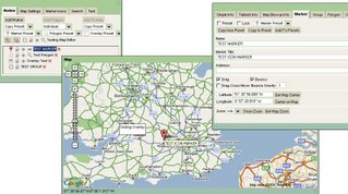
Stefan Blanke has been working on a very sophisticated Google Map Editor

Map Editor in Alpha
The screenshot does not do the 'Editor' justice as there are many editing functions hidden in the tabs.

The Map Editor use a very up-to-date version of the Google Map API (version 2.68 to the coders)
The includes creating Polygon though not implement (maybe version 2.69 needed)
Very Good work though.

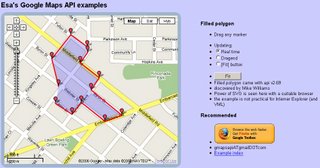
To see editing polygons using that 2.69 version pop over to ESA.
Very good Example of Editing Live on Google Maps.
ESA Edit Polygon Live on a Google Map

So how long before Google Maps becomes 'GOOGLE GIS API'?
At this rate "Early 2007"

Another High End Database (Oracle XE) potential is Oracle XE and Google Maps (though we haven't actually seen the map and data working yet - pre Alpha?)

Labels: , , , , , ,