->

03 March 2009

CloudMade Map Editor

CloudMade Map Editor

update 05/03/2009
CloudMade feedback (see comments) looks promising. Thanks for the kind remarks, always willing to help a brilliant minded concept.

Ever wished you can create your own style of map online?
Well CloudMade Map Style Editor might be what you have been waiting for.

"Tired of the same old maps? CloudMade's Style Editor lets you create customized cartography that you can use to distinguish your applications. With the Style Editor, you can easily create a unique map style in a matter of minutes without having to install any special software or have any previous cartography experience"
source:Cloudmade

It uses data from Open Street Map, then allows a logged in user to edit the colour of Roads, Points of Interest [POI], Area features.
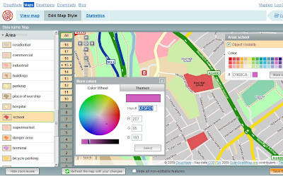
Cloudmade Editor School colour picker
Selecting and editing colours is made easy using this CloudMade Map Style editor.

But what happens if you want different representations of a feature at different scales?
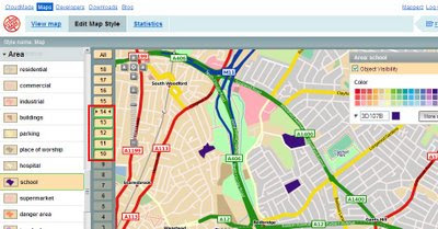
Cloudmade Editor School colour picker - Zoom Levels
Note the zoom scales selected, at these scale you will see a strong purple representation, zoom in and it will be transformed into a more subtle colour (this is only for demonstrating this technique).

Mapperz wish list: (now this is just a very short version)
  • Edit Fonts (Annotation) but notoriously difficult to implement
  • Text Placement, Centre, North,South,East,West placement of point/symbols with text.
  • CMYK colour picker option (for printer), RGB and Hexidemical colours only useful for Screen/Web. See ColorBrewer for this type of usefulness.
  • Polygon to Point Representation [e.g.When a School is at an unsuitable scale for area representation is can be displayed by a point/symbol instead)
  • Preview/Outline Mode (with Auto Refresh) - currently the user requires to click 'refresh the map with your changes' button. Outline mode for seeing the nodes and segments. Similar function is in Adobe Illustrator.
  • Reorder Layers, ranking structure - sometimes having polygons above features can be useful, like a masking out polygon.
  • Export File like Illustrator. (maintaining styles and line widths with attributes).
  • Grid or Graticule Option.
  • Fix the Help [http://www.cloudmade.com/site/products%2Fstyle-editor%2Fhowto] The requested URL /site/products/style-editor/howto was not found on this server.
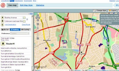
CloudMade Custom Map Directions
And finally you can already add routing/directions to you customised map, this is because the underlining data has not been changed. Only the graphical representation of the data has been customised.

This is just one of many products CloudMade is offering - here is a full list of all.
http://cloudmade.com/products


Some have already created their own map styles, this are available to view
http://cloudmade.com/products/style-editor/gallery


Below is Mapperz first attempt at showing the schools changing colours when zooming in.


Labels: , , , , , ,

28 February 2007

Cartographic Representations in Google Maps and Virtual Earth

Cartographic Representations in Google Maps and Virtual Earth

Cartographic Representations in Google Maps

Cartographic Representations
are part of ArcGIS 9.2 that improve the cartographic elements of GIS data, making it aesthetically more pleasing.

However Brain Flood spatialdatalogic.com has been working on some clever techniques to
make this end result available through Google Maps and Virtual Earth

"Topo Map - this is an export of one of the Cartographic Representation tutorials. It's a good example of complex, scale dependent map symbology"


Cartographic Representations in Virtual Earth

This is driven by Amazon Web Services Amazon Simple Storage Service

"Amazon S3 provides a simple web services interface that can be used to store and retrieve any amount of data, at any time, from anywhere on the web."

Combining these services is producing some very powerful applications on which one could dream up a few years ago.

Nice work more please - Mapperz


Labels: , , , , ,

29 January 2007

Cartographic Representations - OverPass (Part 5 ) of...

Cartographic Representations are a big leap in ArcGIS 9.2

It allows the GIS/Cartographer more control on how the Map is displayed and this has been covered in Parts 1-4.
Part 4
Part 3
Part 2
Part 1

However this is part 5 but on requests from regular blog readers and ArcGIS users, there will be more examples on Cartographic Representations.

The gap between ESRI USA and ESRI UK Users has been 2 months hence why this post has taken so long to get on the blog. Mapperz has only used ArcGIS Desktop 9.2 Arc/Info for 2 days, one day was updating all the service packs

Please note this functionality is only available with ArcGIS Desktop Arc/Info (the super expensive one)

Carto what? Overpasses??
Cartographic Representations Overpasses Image source ESRI
Image Source: ESRI
  • Generates mask polygons at the intersections of stroke representations to symbolize one set of strokes passing above the other. Optionally, linear parapet features can be generated adjacent to these masks.
  • Requires intersecting line features symbolized with stroke representations as inputs.
  • Feature classes without representations are not supported by this tool.
  • The Input Above Features With Representations layer can be the same as the Input Below Features With Representations layer in the case of self-overlapping features.
  • When Input Above and Input Below representations are the same, a SQL expression is encouraged for further refinement of feature selection.
  • Overpass masks are created based on the user-indicated margin sizes.

This post covers Overpasses (where a road overpasses a railway/railroad).

This Tool is found in Cartography Tools > Symbolization Refinement > Create Overpass

First you need a Cartographic pair of representations to be able to do this. Mapperz is using the Examples are using the ArcGIS Tutorial >ArcTutor\Representations\Exercise_1.mxd

Convert Symbols to Cartographic Representations

Converting to Representation

Representations Overpass Function
OverPass dialog in ArcTool Box in ArcMap 9.2

Representations Overpass Processing
Processing.... yawn.

Representations OverPasses Completed

Result - This has been emphasized in Red and larger than normal for a project to create OverPasses.

The same method can be also applied to UnderPasses

Stand-alone Maplex user? (Not ArcMap Labelling Extension)
Underpass/Overpass can be exported to shapefile format and used to mask road/rails etc for Adobe Illustrator export (recommended as ESRI Export still not quite there from ArcMap).

Labels: , , , , , , ,