->

28 June 2007

Google Maps - Drag Directions (New Feature)

Update - The official post with video now available

http://maps.google.com/help/maps/directions/


Funky new feature from Google Maps - Drag Directions...on the fly.

Here's what Mapperz likes about it.

Google Maps Directions - Drag Route
Now if you grab the blue directions line on the map

Google Maps Directions - Drag Route Alternative
Google then re-calculates live on the fly new route.

Try it out

Also when you right click on the blue directions route you can specify a new destination stop.
Right Click on Map adds New Destination
Dynamic Routing is alive!!

Well done Google. :)

Labels: , , ,

Map Your Picasa Web Photos

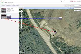
Map your photos

See your photos arranged on a map, and show friends exactly where you took your best pictures. Simply type a location into the ‘Place Taken’ field when creating a new album, or refine a photo’s placement using a drag-and-drop map. It’s a great way to share photos from a summer vacation or road trip.

Example (Official)

Source: Googlified

Mapperz Demo

Geotagging (Georeferencing) Photos in Picasa New Feature

To manually Georeference your photos, select the album and view map enter a rough location, then centre the map and zoom in to where you remember the photo was take. Pick up the photo thumbnail and drag it across the map. Then the Latitude and Longitude is automatically assigned to the image. Simple as that.


Labels: , , , ,

27 June 2007

Sky News - UK Flooding Map (Pics)

Update - if your looking for UK Floods in Southern, West and Midlands [20th July to 24th July 2007]
Go to the newer page
http://mapperz.blogspot.com/2007/07/uk-flooding-links.html


Sky News UK Flooding Map showing pictures of the Flooding in the North of England - News has Location.


Sky News UK

More and more Maps are Illustrating news events - giving the users a sense of the scale of the matter.
(other parts of the UK have been affected - though the North of England has had it very bad.)

Source: Google Maps Mania via Press Gazette

More Flooding Pictures from the BBC Site

Labels: , , , , ,

26 June 2007

Environment Agency - Adds Pollution Maps

Environment Agency - Adds Pollution Maps
(as well as Flooding)

Environment Agency Pollution Maps

You can now select individual polluting gases and their location that can be define and find more information about the substances
example
Carbon Dioxide

Main Sources of Air Pollution


  • Air quality and emissions
    Find out how air quality has changed over time, and how emissions of different substances impact on the environment and health.

  • Air pollution incidents
    In 2005 154 pollution incidents had a serious impact on air quality in England and Wales, the lowest number on record.

  • Acid rain
    Acid rain has been tackled for over a decade with some success.

  • Ozone depletion
    Ozone in the upper atmosphere shields the earth from harmful ultra violet (UV) radiation emitted by the sun. Man-made chemicals have damaged this “ozone layer”, allowing more UV radiation to pass through.

Other Sources of Pollution


  • Pollution incidents - Pollution incidents such as oil spills or the accidental release of raw sewage can damage the environment, harm wildlife and pose a threat to human health.

  • Ozone depletion- Ozone in the upper atmosphere shields the earth from harmful ultra violet (UV) radiation emitted by the sun. Man-made chemicals have damaged this “ozone layer”, allowing more UV radiation to pass through.

  • Acid rain - Acid rain has been tackled for over a decade with some success

  • Noise - Noise from industry, traffic and homes can annoy, disturb sleep and affect health.

  • Light pollution - Light pollution has reduced our ability to view the night sky and causes impacts on wildlife. England is more brightly lit than other European country with the exception of the Netherlands.

  • Environmental Crime - Illegal activities can directly harm wildlife or the environment. This section covers breaches of permits and fly tipping.

  • Nutrients in rivers, lakes and coastal waters - Nutrients are essential for aquatic life, but high levels can upset ecosystems, create unsightly algal blooms and even threaten our health.

  • Fertilisers - Fertilisers must be used with care to avoid pollution.

  • Pesticides
And they still deal with flooding. But check your local area - the data and mapping for flooding is a little dated in places.

Environment Agency Flood Maps
EA vs OnOneMap Technologies
Comparing Environment Agency 'Mapping' (not data) with OnOneMap
Users prefer ease of use with OnOneMap.

Labels: , , , , ,

22 June 2007

ViaMichelin API Geocodes UK Addresses

ViaMichelin API Geocodes UK Addresses

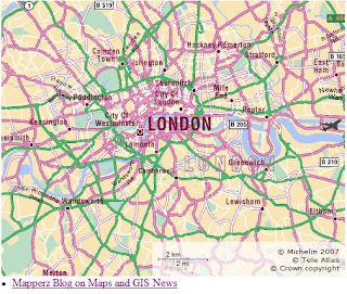
Michelin Maps API - London Map

Works like other Mapping API's out there but is more specific to the European user


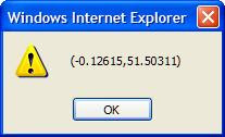
    Geocoder UK Manual showing AlertUK Address Geocoded Alert


      This Geocoder Requests a UK address and returns the lat and lng in an 'alert'
            Yes a bit manual at present, but if your a dab good at Javascript - you can add the map element request an address and have it return on the map.

            ViaMichelin API Map Features:


            • Michelin's high quality maps on-line
            • Driving Directions with 7 types of itinerary : ‘recommended by Michelin’, ‘shortest’, ‘quickest’, ‘economical’, ‘scenic’, ‘on foot’, ‘by bike’.

            • Assure a seamless integration with your site’s look and feel by customizing the colour, opacity and stroke width of the itinerary path displayed on the ViaMichelin map.

            • A proximity and booking search engine, unique in Europe, integrates over 40,000 hotels

            • Checking address and geocoding for exceptional accuracy

            • Implemented entirely in JavaScript, a simple, standard technology!

            If you like this you can sign up (free) to use this service

            Thanks to http://www.renalid.com/ (in French)

            More information on the ViaMichelin Blog

            (ViaMichelin is a subsidiary of Michelin)

            Mapperz

            Labels: , , , , ,

            21 June 2007

            PawTrax - Lost or Stolen Cats & Dogs Map

            PawTrax - Lost and Stolen Cats and Dogs Map
            For UK owners of Cats and Dogs whom have lost their faithful friend. A unique way of finding and tracking down canines and felines that have either been lost or have been stolen from there home.

            "A PawTracker is a concerned fellow dog, cat or pet lover who would like to assist in finding missing pets. In fact. you do not need to be a pet owner, just someone who loves animals and would like to help in the search for missing pets"

            Paw Trax Map
            The very clear and useful sidebar with legend helps narrow down searches quickly

            Dog
            Cat
            Horse
            Bird
            Small Furry
            Other

            Note: 'Other' could equal snakes!

            Paw Trax - Lost Cat

            "A Helping Hand for a Lost Paw"

            http://www.pawtrax.co.uk/map/locations/map

            Nice to see different types of Mapping like this.
            Suggestions - Mapperz at gmail dot com.

            Labels: , , , ,

            State of the Map 2007 - Manchester

            The OpenStreetMap Foundation are pleased to announce that
            Ed Parsons will be delivering the Keynote presentation at
            the State of the Map 2007, on Sunday 15th July 2007.
            Ed is a well known and respected figure in the geospatial
            community, whose long-term interest in OpenStreetMap
            is know to many. In his new position as Google’s Geospatial
            Technologist for Europe, Middle East and Africa, Ed is in a unique
            position to talk about OpenGeoData. His talk is titled “The Cathedral
            and the GPS - a personal view” and promises to be a highlight of the
            action packed SOTM07 weekend.

            Mapperz picks out some interesting topics...


            If there are Dragons there, it will be good.

            There more information added here
            http://wiki.openstreetmap.org/index.php/State_of_the_map

            If your interested in Mapping Technology and in the Manchester area
             it's worth attending.


            http://www.stateofthemap.org/

            Labels: , , , ,

            19 June 2007

            Local Search for the United Kingdom Launched

            Local Search for the United Kingdom Launched

            "For users already using the AJAX Search API for local search you should now be able to search for businesses in the United Kingdom without having to make any changes to your code. Go ahead and now try "Starbucks near London" in your A
            pp that uses the Google AJAX Search API. You should get something like the following:"

            Starbucks Near LondonMapperz Map Search now works for the UK!
            Mapperz Map now can return UK Businesses from the Search ( found right hand column of this blog)

            Labels: , , , ,

            18 June 2007

            Better European Driving Directions - Yahoo Maps

            Yahoo Maps are now providing better European driving directions.


            Now you can cross borders and sea's and get accurate driving times (exclude traffic jams) to places right across Europe. The Example shows from Belfast to Galaţi (Eastern Romania) Stopping off in Paris (for a croissant) will take you 41 hours and 8 minutes (approx).

            Driving directions within 34 European countries include:

            Western Europe - Complete coverage
            Austria, Belgium, Denmark, Finland, Germany, Great Britain, Luxembourg, Netherlands,
            Ireland, Norway, Portugal, Spain, Sweden, Switzerland, France, and Italy.

            Eastern Europe – Comprehensive coverage
            Albania, Bosnia/Herzegovina, Bulgaria, Croatia, The Czech Republic, Estonia, Greece, Hungary
            Latvia, Lithuania, Macedonia, Poland, Romania, Russia, Serbia/Montenegro, Slovakia, Slovenia, and Turkey

            Redesigned interactive print page makes it easier to print and read driving directions.

            Yahoo will introduce new in-country Maps sites in France, Germany, Italy, Spain and the UK.

            (You can already take a look at Yahoo! Maps India, currently in beta)

            Labels: , , , ,

            16 June 2007

            New Faster Maploader - Nokia

            New Faster Maploader - Nokia

            New Maploader v1.1

            Faster MapLoader 1.1 downloading map data has improved vastly :)

            New Maploader Voices

            Now comes with voice commands in 24 Languages.
            English (UK) has 0.2mb more the English(USA).

            Nokia Maploader v1.1 New Data UK

            Checked UK differences in Data from the last upload.

            England has more data was 90.3mb now 95.8mb (6% increase in detailed coverage)
            Northern Ireland has more data was 6.6mb now 6.7mb (1.5%)
            Wales has much more data was 12.7mb now 16.7mb (24% increase)
            Scotland 18.4mb now 19.4 (6% increase)

            New Maploader Speed is much better
            England at 95.8mb was downloaded in less that 8 minutes, the software then transfers to the memory card and verifies the map data has been completed successfully.
            Voice for English [UK] took 45 seconds to download and a minute to transfer and verify.

            Smart2Go update coming very soon.
            More on this over at
            http://www.allaboutsymbian.com/

            Tips- 1. BACKUP YOUR PHONE - VERY IMPORTANT! - Use Nokia PC Suite Backup to your PC and the backup function on your phone - backup phone to memory card.

            2. FLASH YOUR FIRMWARE, v11.0.026..... is the latest *#0000# will show your version on screen on your phone.

            Go get Maploader v1.1
            and enjoy free digital maps on your phone.

            Mapperz

            Free Maps, Nokia,N-series,N95, Maploader,

            Labels: , , , , , , ,

            15 June 2007

            Updating Maps, on the Fly with TomTom Map Share™

            Updating Maps, on the Fly with TomTom Map Share™
            A Web 2.0 Solution?

            "Map Share™ is a proprietary map improvement technology unique to TomTom, which enables users to easily and instantly improve maps. TomTom users can respond in real time to changes in the road network and correct the maps on their TomTom devices accordingly. Thanks to the smart user interface, it is easy to make improvements, such as blocked or unblocked streets, reversed one way traffic or new street names, which will instantly take effect."
            (The TomTom satellite navigation community has over 10 million users.)

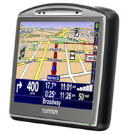
            TomTom GO 720
            Featured:TomTom GO 720
            Image Source: TomTom

            But how many will actually use the updating software?

            The MapShare software will be released for older TomTom GPS units

            Labels: , , , , , , ,

            13 June 2007

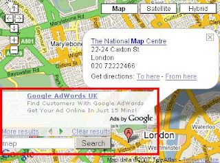
            Google Maps & AJAX Search with Adsense (MapSense?)

            Yes it is working....

            Map With Adsense Working

            But not officially documentated...

            http://mapperz.googlepages.com/local_search_with_adsense_ajax_api.html

            Mapperz

            Labels: , , , ,

            Google Maps API and AJAX LocalSearch Control

            Google Map API and AJAX Search API get closer ...

            the one liner that makes it happen
            map.addControl(new google.maps.LocalSearch());

            Update Please Note: Adsense is not Enabled yet but in the pipeline.


            Note: Google will serve advertisements if you use this Local Search Control.

            In addition to providing useful search results to users of your Google Maps API powered site, the Local Search Control for Google Maps is designed to help you make more money from your maps mashup. Search is a great opportunity to target relevant AdSense ads to users of your site. If you pass your AdSense ID into the constructor of your Local Search Control, then you will share in the revenue from clicks on the AdSense ad(s) generated by the Search Control. If you do not provide your AdSense ID, then ad(s) will still be served, but you will not receive revenue from those advertisements.

            Embedded AJAX API Local Search Control in Google Map

            http://mapperz.googlepages.com/new_local_search_ajax_apiv3.html
            (corrected url for the css)

            Official Post
            http://www.google.com/uds/solutions/localsearch/compact.html

            Google Map API response
            http://googlemapsapi.blogspot.com/2007/06/localsearch-control-letting-users.html

            more info and stay tuned on Adsense in Google Maps!:
            http://www.google.com/uds/solutions/localsearch/index.html
            http://www.google.com/uds/solutions/localsearch/adsense_gmlocalsearch.html

            Labels: , , , , ,

            12 June 2007

            ESRI Users Questions Answered

            ESRI Users questions answered from ESRI International User Conference 2007

            ESRI Website

            Mapperz Mixed Pick from http://gis2.esri.com/library/userconf/index.html


            When will ESRI certify support on Microsoft’s Vista operating system?
            We will complete our testing and add support for the Microsoft Vista operating systems in the third quarter 2007 for ArcGIS Desktop 9.2. We will support all products on Windows Vista at the ArcGIS 9.3.

            NOTE: Due to some issues with Vista, several patches from Microsoft will be required in order to run ArcGIS under Vista.

            What is the status of ESRI’s support for running ArcGIS on 64-bit operating systems?
            ESRI is currently performing certification testing for ArcGIS Desktop 9.2 to support 64-bit processors. This will be delivered with service pack 3 in July.


            What is ESRI doing in ArcGIS to make it easier for users to share geoprocessing models and best practices?
            ESRI will publish a new Web site named the Geoprocessing Center to coincide with the ArcGIS 9.3 release in an effort to promote the sharing of geoprocessing models and scripts among the ArcGIS user community. This new resource center is part of the ESRI support site. By openly sharing these models and scripts, we can help each other learn and apply geoprocessing for solving many types of problems. ArcGIS 9.3 will make it easy to publish models to, as well as search for and download models from, the Geoprocessing Center.


            When will ESRI support better handling of graphical exports of large format maps (72 x 55 inches and larger)?
            The next major release after ArcGIS 9.3 will include a new plotting and graphic display system that will significantly increase display performance and support large format map export as a primary capability.


            Can you improve the performance of the “Near” spatial analysis tool?
            (Requested many times to ESRI UK - you try using 'near' with 28 million addresses)

            Yes, ArcGIS 9.3 will include a new approach for performing proximity analysis that substantially increases the performance of the Near tool. New functionality will be provided that calculates the distances between and among various features (points, lines, and polygons). The output of this function will be a new "near table" that can be subsequently used for various kinds of spatial analysis (e.g., spatial statistics).


            What is ESRI doing about the speed of ArcMap?
            In the next major release after ArcGIS 9.3, ESRI will implement a new display pipeline into ArcGIS that will radically improve display performance and scalability.


            Microsoft is developing a spatial type in SQL Server. Will ESRI be supporting this?
            (codenamed 'Katmai' will be SQL Server 2008 with Spatial Database Support.
            This manages any type of data from relational data to documents, geographic information and XML.)

            Yes, ESRI is working closely with Microsoft and will release support for this spatial type as a standard part of ArcGIS clients (direct connect) and ArcGIS Server (ArcSDE gateway). This capability will be supported with ArcGIS 9.3. We will coordinate the timing of the release of this functionality with Microsoft’s release schedule.
            Microsoft SQL Server 2008 Spatial
            More info on Microsoft SQL Server 2008
            http://www.microsoft.com/sql/prodinfo/futureversion/default.mspx

            Labels: , , , , , , , ,

            11 June 2007

            High Resolution Images - Google Maps UK

            High Resolution Images - Google Maps UK
            Goonhilly Cornwall High Res
            Goonhilly, Telecommunications, Cornwall can now been seen clearly in Google Maps

            "The huge imagery update which came out for Google Earth on June 2nd is now available in Google Maps. There are Digital Globe satellite photos for random places all over the world, most of England is now at high resolution (50 cm/pixel), and many other places as well. Google mentioned during a conference last week that there was more data added in this update than existed in all of Google Earth before a year ago. Read below for the details on the imagery from Google. "

            Labels: , , ,

            08 June 2007

            Google Developer Day 2007 - Map Slides

            Reference Links for the main features that were unveiled from Google Developer Day 2007 in London.


            Yes there is Adsense Code for Google Maps API but is not available until the 2.82 version of the API.

            http://www.google.com/apis/maps/documentation/mapplets/
            http://code.google.com/apis/kml/documentation/kml_tags_beta1.html
            http://gears.google.com/

            Google Maps API Adsense
            Adsense in Google Maps API
            Source: Mapperz (N95)

            The Maps API allows you to embed geographical information into your site using JavaScript, you can add overlays to your map including markers, polylines and shadowed information windows. It is a great way to enhance your current site content and best of all, using the Google Maps API is free. To learn more and to find out whether your site meets the terms of use, visit the Maps API FAQ.


            more information
            http://googledeveloperday2007-uk.blogspot.com/2007/05/mapplets.html


            Driving Directions now available in Google Maps API
            http://www.google.com/apis/maps/documentation/#Driving_Directions

            Mapperz Example
            http://mapperz.kml.googlepages.com/uk_driving_directions_api.html
            (though does not support UK driving directions thus far)

            Labels: , , , , , , ,

            07 June 2007

            MapInfo Professional 9.0 - Released

            MapInfo Professional 9.0 - Released

            MapInfo Professional 9.0


            Top New Features are:

            • Save Window as GeoTiff (Georeferenced ScreenShot)

            • Direct Access to ESRI Geodatabases (File and Personal GDB), DWG,DXF and DGN files.

            • On-the-fly Indexing (Geocoding TAB files and Remote Tables)

            • Curved Text Placement (Wow! about time)

            • Time Based Analysis of Data - Change over time.

            • Supports Windows Vista (Ultimate only)

            More Info and PDF's

            Source: http://slashgeo.org/

            http://technology.slashgeo.org/technology/07/06/07/1345221.shtml


            Mapperz

            Labels: , , , ,

            Google Map API Developers Listen - DragZoom

            This post proves that Google listen to people who use Google Maps everyday.
            DragZooom Action DragZooom Complete
            Using the Drag Zoom Icon The Result - exactly the area you want


            Thank you Google Maps API Engineers/Developers for providing this feature.
            Thank you Pamela for posting it on the Official Blog.

            http://googlemapsapi.blogspot.com/2007/06/dragzoomcontrol-v10-easier-zooming_06.html

            Mapperz originally post this 'suggestion' in the API Feature Requests
            wayback in February 20007.

            Labels: , , , ,