->

30 January 2008

Nokia Beta Labs - Location Tagger

Nokia Location Tagger
(georeferencing your phone camera photos)

Nokia Location Tagger

"What is it all about? Nokia Location Tagger is a small application running on “selected” S60 3rd devices that allows you to tag pictures captured from Camera application with geographical coordinates from GPS. The tagging process itself is sometimes called geotagging or geocoding (see also this article at Wikipedia). Technically, the location information is stored in the EXIF header of your pictures (.jpg file)."

Nokia Location Tagger S60


With Nokia Location Tagger, you can automatically tag your location data to your pictures. As you take a picture, your GPS coordinates are saved to the EXIF header of the JPEG file. You can use this data later, for example, to locate your pictures on a map.
In the near future, we hope to make location tagging a seamlessly integrated part of your Nokia experience. Until then, Nokia Location Tagger is a small standalone application that gives you a sneak preview. We are not planning to productize this application as such, but we’d love to hear your thoughts already now, so that we have time to take it into account in the mainstream development.
Tested with Nokia N95, N95 8GB, N82, and E90 using the integrated GPS. Should work but not fully tested with all S60 3rd edition devices using an external Bluetooth GPS receiver. Sharing your location-tagged pictures online requires Share Online 3.0.

- Launch Nokia Location Tagger application.- On the main screen, you will see the status of your GPS module. It will show the coordinate if GPS module is active. Otherwise, it will show "Searching".- To tag pictures with GPS coordinates, simply use the built-in Camera application. Press the Camera button of your device to take pictures as usual. When Nokia Location Tagger is running in the background, you will see small icon at the top left corner of Camera’s view finder. This indicates the status of GPS module: Green: GPS module is active. Amber: Nokia Location Tagger is connecting to GPS module or searching for GPS coordinate. Red: GPS module is inactive.

Q: What happens if I take pictures while the GPS module is not active yet?

A: Nokia Location Tagger tries to tag pictures to the last "known" coordinates in the last 10 minutes. Since GPS module normally takes some time to initialize, it’s better to launch Camera application a couple of seconds before taking pictures. Launching Camera application will activate Nokia Location Tagger; which will initialize GPS module. You can also bring Nokia Location Tagger window to the foreground to initialize GPS module.


Q: Will my battery be empty very fast when running Nokia Location Tagger in the background?A: Nokia Location Tagger has a time-out feature (by default, it is 5 minutes). If there is no picture until time-out time, the GPS module will be turned off. This will normally save power. you can change the time-out option in the settings (2, 5 (default), or 10 minutes)

Q: How can I view the GPS coordinates of my pictures?A: The GPS coordinates are stored in the EXIF header of JPEG files. Some online sites, such as Flickr and Panoramio are able to display GPS coordinate from the EXIF. For more info on these services, please see below. You can also use photo organized software that read EXIF, such as Picasa (with the combination of Google Earth).
Q: How can I set Flickr to automatically import location in my uploaded pictures, and place them on a map accordingly?A: Please go to this URL: http://www.flickr.com/account/geo/exif, sign in, tick the yes please box and click save. From now on, all new tagged pictures that you upload will automatically be placed on a map. Also underneath every picture, there will be a map link that - after you click on it - shows where the picture is taken. Here are some examples. A nice alternative to Flickr is Panoramio. After uploading your pictures, you can view them on Google Maps but also export them to Google Earth. Here are some examples.
issues- The pictures from secondary camera are not tagged. Nokia Location Tagger tags pictures from the main camera only.- In a very rare case, Nokia Location Tagger may not be able to tag picture with the error message "File is being used".- Pictures captured in burst mode may not be displayed in order in the Logs tab.- This version has been tested on N95, N82, E90 as well as N73, N81 with external GPS module (Nokia LD-4W). It should work on all other devices; but there is no guarantee at this point.

What can we do with the Geo-tagged pictures? You can upload them to the photo sharing sites, such as Flickr, Panoramio and Picasa Web, so that your friends know where the pictures were taken. If you want to keep them private on your PC, some photo organizer applications, such as Picasa (combined with Google Earth), are able to display location information.
Please read the instructions at Nokia Location Tagger web page.

Labels: , , , , , ,

22 October 2007

MapCruncher (VE beta Version) +Quick Guide

MapCruncher (VE beta Version) Quick Guide

Custom Map in 3D MSVE
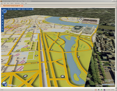
Your own Custom Map in Virtual Earth in 3D (London is a bit too flat) Buildings are from Microsoft Virtual Earth.

What is it?
Crunches Maps!
Generates Custom tiles in from one image into tiles at different zoom levels

Okay what do I need?
MapCruncher VE version (beta)
some space on your pc
*not much knowledge on web programming

.net version 3.0 framework is required to use this program (but it's worth having anyway)

How to use it
have a digital version of your map - and make sure you have copyright on the map source.
(tif,gif.jpeg,pdf,png can be used.)
at least 150dpi, try at 300 and your map will be clearer (less fuzzy)


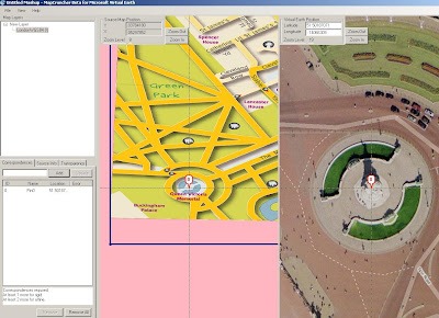
Georeference the image - this shows you how - at least 3 points are needed - 4 is best.

Map Cruncher Georeferencing
locate both 'locations' and add a marker on virtual earth base, once three locations are done it can be locked.

Lock the Image to the Virtual Earth (VE) map

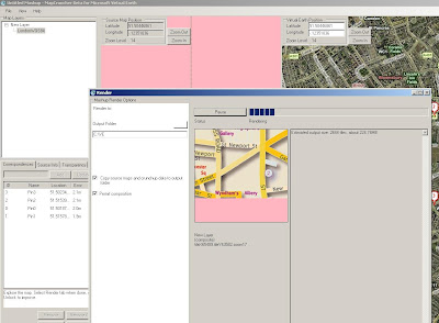
Rendering.... THE MAP CRUNCHING BIT! (can take a while with big images) - this one took 20 minutes.
The good thing here is that it is an automated process - only 'map crunching' computer time

Map Cruncher Rendering
This is automatic - just have a new folder for the images and html to go.


This even creates a sample html page to get you up and running.

But I want 3D!

OK you cannot view 3D on your local computer - but you can if the 'map crunched' data is uploaded to a webserver (http only)

File sizes - ok the little issue here is that many images created for zoom and panning.
This map is 236MB so it can take a while to upload to a webserver..

But then once on the webserver - you can view it in 3D

try
http://www.mapsinternational.co.uk/ve/samplepage.html
try and let the image load up first (post-cache)

(ok, ok London is a bit flat!)

But this can be done for more undulating areas!

Can this be used for other mapping API's?
Looking into this using Google Maps API, Multimap API and Yahoo Maps API.
(in theory yes)

Mapperz

Labels: , , , , , ,

14 September 2007

Yahoo! MapMixer + Quick User Guide

Yahoo! MapMixer + Quick User Guide

What is MapMixer? "The world is a big place. There are thousands of maps out there that provide unique details about any given destination. MapMixer is a new site that combines those maps with Yahoo! Maps to give you a better view of the world. It's easy to mix your own map. Upload an image of your map, use our layering tool to align it with Yahoo! Maps and we'll do the rest! Your map will have all the features of Yahoo! Maps (zooming, panning). You can also syndicate it on your own site or blog."

Quick user guide
Sign in to Yahoo.
Upload your jpeg,gif or bmp.
(no tif support at present.)

Yahoo Map Mixer Georeference Point
Two Points are needed to estimate the geographical position of the image.
Traditionally in a GIS environment this is at least 3 points.

*Top Tip - use the opacity setting

Yahoo MapMixer Georeferenced Opacity Setting
Use the control points on the edges of the image. Yahoo Mapmixer allows you to unpin your image which enables the moving of the yahoo map base


Yahoo MapMixer Georeferenced Rotate Image
Use the green circle to rotate the image - this helps to get an exact fit of the image.
*rotated image exaggerated here for example of the function.

Reproduced from Ordnance Survey map data by permission of the Ordnance Survey © Crown copyright 2001.

Map Source
http://www.ordnancesurvey.co.uk/oswebsite/freefun/outlinemaps/

"You must not use the images for financial gain. All hard copies and electronically published material produced from Ordnance Survey data must carry the acknowledgment:
Reproduced from Ordnance Survey map data by permission of the Ordnance Survey © Crown copyright 2001."

not sure about the hula hooping mice - a progress bar maybe?

Please observe copyright Christian Spanring explains it clearly

Labels: , , , , ,

28 June 2007

Map Your Picasa Web Photos

Map your photos

See your photos arranged on a map, and show friends exactly where you took your best pictures. Simply type a location into the ‘Place Taken’ field when creating a new album, or refine a photo’s placement using a drag-and-drop map. It’s a great way to share photos from a summer vacation or road trip.

Example (Official)

Source: Googlified

Mapperz Demo

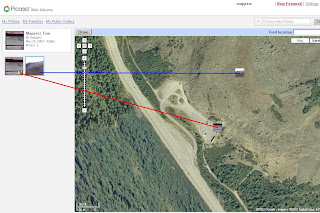
Geotagging (Georeferencing) Photos in Picasa New Feature

To manually Georeference your photos, select the album and view map enter a rough location, then centre the map and zoom in to where you remember the photo was take. Pick up the photo thumbnail and drag it across the map. Then the Latitude and Longitude is automatically assigned to the image. Simple as that.


Labels: , , , ,