->

31 July 2007

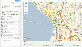
Sponsored Links - Google Ads on Maps

Google Maps API on Version 2.85 of the API now integrates Adsense and the mapping together

Google Maps API sponsored links(ads) on a map
http://mapperz.googlepages.com/sponsered_links.html
though you will have to pan to the USA to get a sponsored link box
(Mapperz waiting for the UK to come active, have tried different text , vets, plumbers, doctors etc)
If you find a sponsored link in the rest of the world, post a comment

the code to add ads is
var adsManager = new GAdsManager(map, "Your AdSense ID");
adsManager.enable();

*remember you don't have to

No Official Post on this yet, and still very beta. Mapperz tries to do a UK based version but either no sponsored 'paid' links or is refined to USA only so far. There is not a lot of code or details how and when ads appear.
There have been a few suggestions on the Google Maps API group.

Here is Pamela Fox full text example then to Mapperz tinkering version...


It's seems to be based on the text associated with the page, which is okay, though prefer the AJAX Search ads method based on the users search.

A great potential to get your maps making money while you sleep!

Previous post on adsense in AJAX local search

Labels: , , , ,

30 July 2007

192.com Mapping Updated

192.com Mapping and API Updated

  • 12.5cm resolution aerial photography UK-wide
  • Ordnance Survey maps with 100% of streets labelled
  • Maps based on Flash technology

192.com has just launched a number of new enhancements to its interactive mapping tool including the highest resolution aerial photography, exclusive UK styled maps and a new journey planner

Kwik fit 192.com flash map

Kwik Fit uses 192.com Mapping for their website and works well.

These features make 192.com Maps a dynamic user experience designed specifically for the UK market.


"192.com is today announcing the first in a series of major improvements to its maps service, first launched last autumn and experiencing a surge in traffic in recent months. 192.com has republished all of its street maps after exclusively redrawing every UK map to incorporate the latest Ordnance Survey data and ensure street labelling was in an easy to read format. 192.com is unique on the internet for labelling 100% of UK streets (typically rival sites name 70-80%) and so uses hand drawn labelling particularly for crowded, historic cities with many street names in close proximity. The colouring of the maps has also been optimised to suit motorists and non-motorists alike and to accommodate the changing requirements of computer and mobile screens. The aerial photography, already acclaimed as the best available for the UK, has improved further and offers unrivaled clarity and resolution nationwide, not just in cities. But it’s the transition between maps and photography that really sets 192.com’s new maps apart, with the smoothest, cleanest transfer from map to map, and map to detailed aerial photography."
Having looked into these at more detail there seems to be a lot going on under the hood.
If your an experience programmer you will able to create flash based maps in a few minutes
Though a quick start tutorial with live example would aid the non-experienced programmer.

Clearly the mapping is excellent and well put togeather and seems to be the only online mapping fully based on Ordnance Survey Mapping. This must of cost a small fortune to buy or licence.

Here is a list of the scales available

  • 0 = 0.125 metres/pixel Aerial Photo
  • 1 = 0.25 metres/pixel Aerial Photo
  • 2 = 0.5 metres/pixel Aerial Photo
  • 3 = 0.125 metres/pixel Aerial Photo
  • 4 = Street level OS map
  • 5 = OS map
  • 6 = OS map
  • 7 = OS map
  • 8 = OS map
  • 9 = OS map (most zoomed out – whole of UK)
Hopefully the Roads data was based on OS Integrated Transport Network (ITN )
as the OSCAR Dataset is now withdrawn

Labels: , , , , ,

26 July 2007

MapJack Beta

An interesting mock up and revamp of Street View in Google Maps API.

MapJack Beta
This is very easy to use and is very responsive to the users input.

Available for San Francisco only at present and is beta status

Street View just got even easier.

View the Map (as the image above)

Mapperz

Labels: , , ,

24 July 2007

MyMaps Helping to Map UK Floods

Update

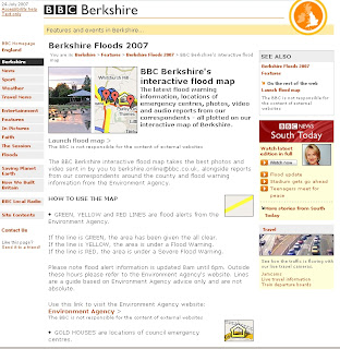
BBC Berkshire's interactive flood map

"The latest flood warning information, locations of emergency centres, photos, video and audio reports from our correspondents - all plotted on our interactive map of Berkshire."

BBC Berkshire's Interactive Flood Map

BBC Berkshire Flood Map Feature

MyMaps helping Map UK Floods and useful up to date information

BBC Berkshire flood Map using Google My Maps
This MyMap records the flooding in Berkshire


The Power of MyMaps is use to display visually and geographically
Thanks to Ed Parsons for finding a map that is more useful and up to date than the Official Government Websites.
Bowser Map using Google My Maps
This map shows the bowsers available in Gloucester and Cheltenham

The cause of the flooding seems to be pointing at the jetsteam shifting south more than normal El Niño and La Niña (the rising and lowering of pressure and temperature in the pacific ocean)
could be possible causes, though human impact seems to cause more fluctuations in this natural process

Jet Stream over the UK in  June 2006Jet Stream over the UK in  July 2007
Images: BBC and the Met Office

Labels: , , , , , , ,

23 July 2007

UK Flooding Links

Update 2
London could be next to see severe flooding

Floods Could Hit London Next

"More than an inch of rain is set to drench the city and this rain, combined with the water that has already poured into the Thames, could burst the river's banks in southwest London.

A flood warning is already in force in Staines and Shepperton, and hundreds of homes could be flooded in the next 24 hours."

Source: Sky News


Update the BBC has created a Map of the Flooding

BBC Flood Map
Source: BBC News

Rivers affectively in severe flood:
  • The Severn: Severe Warnings for Gloucester, Tewkesbury and Worcester
  • The Thames: Severe warnings affecting Eynsham to Sandford Lock and also Little Wittenham
  • The Ock: Severe warnings from Charney Bassett to Abingdon
  • The Great Ouse: Severe warnings from Turvey to Sharnbrook
  • The Avon: Severe warnings at Evesham


UK Flooding helpful links looking for flooding infomation

Tirley flooding near Tewkesbury
Tirley near Tewkesbury (Sky News)

Okay to help users find pictures for the UK Flooding, Mapperz compiles the most useful links...
(this site has been hit hard for 'UK Flood' Maps)

Environment Agency (but not live data)

Best News Coverage so far is Sky News
(updated pics ever hour)

Peoples Flood pics (BBC Content)

Bedfordshire
Travel conditions

Gloucestershire
Travel conditions

Worcestershire (includes Herefordshire)
Travel conditions

Oxfordshire
Travel conditions

If your wanting maps of the floods, your out of luck, currently there are no public out of copyright maps available online that shows live information.

More Flood News

Hope you stay dry - Mapperz

Labels: , , , , , , , ,

20 July 2007

Track Your Shoes (GPS Gadget)

GPS in your Shoes

Ever lost your shoes?

Here is a pair you can always find

GTXC GPS Shoe

"smallest lightest, most durable and powerful electronics on the market today

Interchangeable, waterproof and shock-proof module, from one shoe to the next"

http://www.gtxcorp.com/whatshot.htm

You can track your shoes and view the trail in Google Maps and Google Earth

Using Assisted GPS (now available in the N95 phone also)
PDF on this Technology (for geeks)

But can it recharge by walking?

Which shoe has the chip either or both?

Labels: , , , ,

19 July 2007

ParkatmyHouse & Nestoria

Mapping Sites integrating each others information

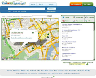
"ParkatmyHouse.com is a brand new and innovative service which aims to provide affordable and penalty-free parking around public venues by enabling property-owners to rent out their empty driveways, garages, car parks and other spare pieces of land to drivers needing somewhere to park.

Motorists and cyclists on their way to work, a big sports match or a hospital appointment for example, can arrange to use a property-owner’s space on a one-off or regular, short-term or long-term basis. Underground and garage spaces offer drivers the added benefits of shelter and security for their vehicles."

ParkatmyHouse

updates now this information is available at Nestoria

Nestoria have recently integrated all of our (parking) spaces in to their website. Do you need a flat in Victoria? Well now you can also find out where you can park, be it in a commercial car park or at one of our user’s many driveways. Simply click on the Parking tab below the map, and nearby parking opportunities are displayed as pins on the map as displayed on the image below."

Nestoria


Mapperz like the way the data is unique and informative on both sites, where ParkatmyHouse is a specific site it adds value to information on localities with Nestoria

Only a suggestion but Directions is a potentially useful option, how far to the parking location from where I am?


Rent a Parking Space with ParkatmyHouse.com

Labels: , , , , , ,

16 July 2007

Tour de France 2007 - Live Tracking and Elevation

Tour de France 2007 - Live Tracking and Elevation

An updated version from last year adds elevation - as well as live tracking even includes heart rate, stress points and distance travel per cyclist

Tour de France map live

Tour de France map live elevation distanceTour de France map live elevation distance
Move the Slider to see location and profile elevation. Also shows Current Distance

come back in 22 hours when the next stage is live to see live tracking.
2006 Version

2007 Version

Labels: , , , , , ,

ArcGIS 9.2 Service Pack 3

ArcGIS 9.2 Service Pack 3 - Announcement

updated post here 01/08/2007
http://mapperz.blogspot.com/2007/08/arcgis-92-service-pack-3-released.html

Mapperz selection.

NIM005448 - X/Y values do not change when you select different Anchor Point icons for a box drawn in ArcMap 9.2. Fixed!
(submitted to ESRI UK back in February 2007 after the first service pack - this tool is very useful when working with Maplex 3.5 standalone which is now unsupported)

NIM001528 - Persist the units that the user chooses for distance and area between ArcMap, ArcReader, and Engine sessions so that the user can set the units once with the Measure tool and not have to set them again.

NIM005560 - Selecting one feature selects everything on a layer connected by an OLE DB connection.

NIM006169 - Export Data from an events layer created from an MS Excel table with a space at the end of one of the field names will cause ArcMap to crash.

NIM007052 - The order of Legend Items does not always match the order of Map Layers.

NIM008619 - ArcMap may crash when editing compressed data.

NIM008671 - Intersect with three or more layers, if one of the layers is points, causes the output to be empty.

NIM008729 - A compressed file geodatabase table or feature class containing text fields with long lengths, such as 2147483647, cannot be read. If you right-click the dataset in the ArcCatalog tree view or attempt to preview the data, ArcCatalog crashes. This occurs in 9.2 SP2 only.

NIM008777 - If you create a selection and delete selected features from the attribute table in the selected view, ArcMap 9.2 SP2 will crash.

NIM006393 - The horizontal ruler in layout view does not automatically update with changes to ruler intervals.


You would think these service packs would get smaller the but seem to get bigger.

For the Full List

Labels: , , ,

12 July 2007

Batch Geocoder to ArcGIS

Batch Geocoder to ArcGIS Tutorial

(for getting Latitude and Longitude for Postcodes and Addresses)

Now this requires a bit of prior knowledge on Geocoding and Basic GIS Skills

Thanks to Google for providing the UK Geocoding in the Google Maps API

Have a set of addresses or postcodes ready.

*but if you intend to do a huge amount of geocoding it's politer to have your own api key rather than using others

example postcodes used in this example (can be 5 can be 50,000)
AL1 1HH
AL1 1HJ
AL1 1HQ
AL1 1HR
AL1 1PW
AL1 1RZ
AL1 1SD
AL1 1SE
AL1 1SF
AL1 1SG
AL1 1SH
AL1 1SN
AL1 1SQ
AL1 1ST
AL1 1SW
AL1 1XU

or use Addresses like
10 Downing Street, Westminster, London, UK
(can be your own list of clients, businesses, store locations etc)

where do they go?

Either
http://www.batchgeocode.com/
or
http://www.gpsvisualizer.com/geocoder/

(for your own version flow instructions at bottom of gpsvisulizer page)
or
http://www.wotton.org/map/batchgeo.html
(recommended for ease of use)
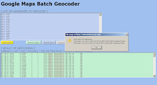
batch geocoders to gis
Copy and Paste in the top light blue box, wait until the alert shows the copy and paste from the bottom green box into a New Spreadsheet.
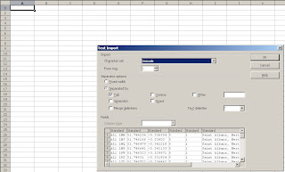
batch geocoders - pasting

Paste into Open Office Calc or Excel with the correct delimiters.
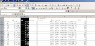
batch geocoders pasting add decimals

Make the pasted lat and lng's six figures in decimal places
save the spreadsheet
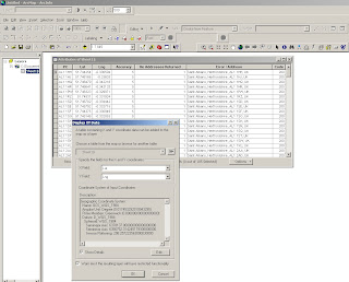

batch geocoding xls arcgis
Add the Spreadsheet to ArcGIS (will need a double click if more than 1 worksheet is in the file)

Use WGS84 Geographical Projection to set the Excel Spreadsheet into the correct projection

Use Add XY Data add the data by Lat/Lng and an event theme will be created, this can be exported out as a shapefile or geodatabase.

Important Note: Geocoder Accuracy
ALWAYS check Accuracy - this shows that the all Geocoders have limitations
This compares Codepoint (accurate to 100m) to the Google Geocoded Postcodes and there is approximately +/- 150 metres error in their location.
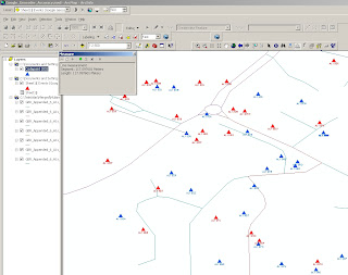
batch geocode check accuracy in GIS

Blue is OS Codepoint in Geographic WGS84
Red is the Google Geocoded Postcodes
(used for a comparison only!)


The method is useful for small datasets, depending on your use.
It could be easily changed to load the geocoded data into a MySQL or Postgres databases for spatial retrieval and added back on to web mapping applications.

Yahoo does Geocode UK Addresses (in some cases more accurate) but it's limitation is that it can only be used on it's on Mapping API and the Geocoder is limited to just 5,000 requests per 24 hours.

For Manual Geocoding
Please use the Official Example:
http://gmaps-samples.googlecode.com/svn/trunk/geocoder/singlegeocode.html

Labels: , , , ,

10 July 2007

SuperPages Beta

SuperPages Beta - using Microsoft Virtual Earth

"Web-based version of the SuperPages. Uses Virtual Earth mapping technology to find businesses and services in your area. Driving directions, hours, and more are provided. Good wifi finder."

Programmable Web

SuperPages Beta - Single Search
Single Search

SuperPages Beta - Multiple Search
Multiple Searches

  • Uses Microsoft Virtual Earth
  • Multiple Search is handy
  • Clunky at times, sends you off to different locations at times.
  • Limited to the USA in Content.
  • But has potential in beta2.

Superpages is part of Idearc Media

Suggest a radial search with dynamic directions
Mapperz

Labels: , , , ,

06 July 2007

Official: UK Geocoding Available to Google Maps API

Official: UK Geocoding Available to Google Maps API

From the Official Post by Pamela Fox Maps API Team
Friday, July 06, 2007 at 1:38:00 PM
"We're quite proud that the Google Maps API community is an active bunch in Europe, and particularly, the United Kingdom. To thank all those enthusiastic developers in the UK, we're happy to announce that the Maps API geocoder now supports address geocoding for United Kingdom addresses. I can now geocode all the places I've visited recently: London, Salisbury Castle, Ipswich, Box Hill, Stonehenge, and my relatives' house in Cambridge (not telling the address!). Try it out with your favorite UK addresses or places below: "

http://googlemapsapi.blogspot.com/2007/07/uk-geocoding-now-available-in-maps-api.html

"Developers should be aware that the API geocoder is not using the same resources as maps.google.com and may not return the same results. You should also know that neither of the geocoders will help you locate the "loch ness monster." Sorry, Google can't do everything (yet)." :)

Mapperz Happy :)

Labels: , , ,

05 July 2007

Free Our Flood Mapping!

A recent article on this Mapperz Blog showed OnOneMap Maps (using Google Maps API) was better than the Environment Agency own Online Mapping.
http://mapperz.blogspot.com/2007/06/environment-agency
-adds-pollution-maps.html

But due to the nature of 'public' data the Environment Agency has told OnOneMap to remove this service as the data is their copyright - excuse me but this is UK tax payers money

"We have had to withdraw our popular and innovative flood map layer, ironically and sadly during one of the worst periods of flooding the UK has ever experienced. The Environment Agency claims they have copyright over the information, and despite the fact that tax-payers’ money has paid for it to be collected in the first place, apparently the tax-payer cannot benefit from innovations like our housing and flood map combination.

For more information on the lack of access the British public have to their data, visit The Guardian’s Free Our Data campaign."

Mapperz hoped the Guardian is reading about this!

Yes they have

http://technology.guardian.co.uk/weekly/story/0,,2118152,00.html

Free Our Data Please. So we can make use of it and provide useful services to the public - like property mapping. Knowing if your house is 'likely' to flood before buying it.

Labels: , , , , ,

04 July 2007

Intelligent Free UK Geocoder - All in One.

Update: Just added [Map-Satellite-Hybrid] Controls
Please use the Official Method
http://gmaps-samples.googlecode.com/svn/trunk/geocoder/singlegeocode.html


Twickenham RFC in Satellite Mode

So you can now see Sports Stadiums

Mapperz looked into revamping the UK Geocoder.

and now rolled it into one.

You can now search UK Addresses, UK Postcodes, Global Airports and Global Place names and find the Latitude and Longitude for all of them - to those who don't know what this is called, it is called Geocoding.

Here are a few Examples to get you searching

London Heathrow Airport, you can use the code 'LHR'
Under the Map is the Latitude and Longitude displayed 'up to' full 12 decimal places (but you only need 6 decimal places for the likes of using Google Maps)

UK Geocoder Airports - LHR


Now for a famous Address
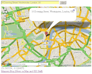
10 Downing Street, Westminster, London, UK

UK Geocoder Addresses - 10 Downing Street

Now how about a large sporting venue?
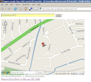
Twickerham Rugby Football Club. You got it

UK Geocoder Points Of Interest - Twickerham RFC

And Famous Postcodes
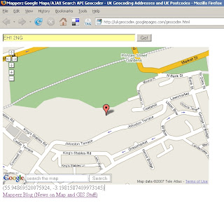
EH1 2NG
(Edinburgh Castle)

UK Geocoder Postcode - EH1 2NG
Please note if you move/pan on the map the lat and lng is automatically updated.
This is simple and smart. Hence why Mapperz likes it.

How is this done?
This is using Google Map API and Google AJAX Search API - Local Search which was improved for UK last week.
Mapperz just displays the returns the Latitude and Longitude at centre of the map after the information is parsed and centred using Local Search.


to remove the icons - just reload the page 'Ctrl F5'.

The Code is available via View>Page Source 'Ctrl+U'

If you want to have your own version you will need change the
Google Maps API Key
Google AJAX API Key
And find a Webserver (Mapperz using Google Pages in this case)

Labels: , , , , , , ,

02 July 2007

More Updates to Google Maps

More Updates to Google Maps - In Summary


India Points of Interest (POI) and addresses are now searchable.

More information in more detail on Google Maps Mania with a full list of Locations

New Coverage - for the United Arab Emirates

Click the image to see it live.

Labels: , , , , ,

01 July 2007

iPhone or N95?

Okay in simple terms why Mapperz bought an N95 and not an iPhone.

The iPhone has:
  • Touch Screen (3.5-inch (diagonal) widescreen multi-touch display))
  • Auto rotate
  • Maps (Google)
  • Quad Band (850, 900, 1800, 1900 MHz)
  • Wifi -Wi-Fi (802.11b/g) no n?
  • 2 Mega-pixel camera (my 5 year old camera has 3mega-pixel)
  • Limited Software available
  • A Polishing Cloth.
iPhone with Map no GPS!
Image:geothought.blogspot.com

Though it lacks one fundamental feature. GPS

If your going to have mapping on your phone, you want to know where you are, not Steve Jobs Office Location.

Just this one missing feature stops Mapperz pursuing the iPhone.

Location based information is useless unless it is providing information around your position or desired destination.

Now if Nokia and Apple produced a product together then it would be a better solution. But this is unlikely.

The N95 has done and is still doing it's job, however the information that phone has in its needs to be updated and cleaned. It is only a computer and can only give you the information it has.
(more map updates from TeleAtlas needed)

N95 has
  • GPS - Locates you in a few seconds (faster in the car with 12v of power)
  • Built in Maps - if you pre-load onto your memory card.
  • Built in Sat Nav with voice commands (if purchased)
  • 5 Mega-pixel camera.
  • Lots of supported software available.
N95 Maps GPS Active
Image:Allaboutsymbian.com

Mapperz own views, comment if you like.

Labels: , , , ,