->

29 January 2009

Vancouver 3D

Vancouver 3D

Vancouver 3D
View this online now at http://mapperz.googlepages.com/Vancouver3D.html
(click 'Earth')
**GE plugin required (installs on demand)

Also available in Google Earth.
(there is likely to be a newer version of Google Earth within the next week - a reliable source)

Source:
http://google-latlong.blogspot.com/2009/01/vancouver-in-3d.html

Future Related: - Winter Olympics - Vancouver 2010
http://www.vancouver2010.com/

Labels: , , ,

28 January 2009

Internet Explorer 8 (RC1) - Accelerator Mapping

Internet Explorer 8 (RC1) - Accelerator Mapping


Internet Explorer 8 RC1 Accelerators Mapping

As you would expect IE8 (RC1) renders Live Search Maps very fast (faster than the IE8 beta versions).

Google Maps in Internet Explorer 8 RC1
So this new browser finally displays Google Maps correctly and with the Release Candidate 1 version. Users of Google Earth 'Earth' Mode (tested with the lastest version of the API here http://mapperz.googlepages.com/LargeMapControl3D_GE.html (click earth) will notice the biggest performance difference - it's much better at rendering the globe at high and low altitudes.

Multimap in Internet Explorer 8 RC1
Multimap does a good job in IE8 (RC1) - panning is smoother tiles are loading faster.

**based on Mapperz 'user experience' only.

on you can add in 'Accelerator' Add-ons
http://www.ieaddons.com/en/mapping/

These 'mapping tools' can help speed up access to Mapping via highlighting a place name, address (including zip or postcode) in Internet Explorer 8 (RC1).

Un-answered questions...
Will FireFox 3.2 be able to compete?
So what will the rumoured Google 'Ocean' be like?
Will Multimap be the better Mapping Portal even after Google Street View launches for the UK?

Old Related Post with Internet Explorer 8 (beta)
http://mapperz.blogspot.com/2008/03/internet-explorer-8-beta-mapping.html

Labels: , , , , , , , ,

26 January 2009

Filmaps.com - Film Locations - Mapped

Filmaps - Film Locations - Mapped

update 27/09/2009
Google Maps Mania Expands the Film Exposure on Maps
http://googlemapsmania.blogspot.com/2009/01/film-locations-on-google-maps.html

Clean cut, easy to navigate, film suggester and maps what else is there...

Film Maps - Bourne Ultimatum
If you know a film well then you can add your own locations and using the 'I know a location' button

"We like films (movies and TV series) and we love travelling around the world, who doesn't?...Sometimes the charm of the places where the films have been filmed wakes up your adventure soul and you would like to discover even visit the exactly place where the scene took place. That's the filmaps aim, the possibility of locating that place!"

There is a lot of activities and tours related with film locations which are designed in order to visit some of them and
recreate the film action. Filmaps wants to help people in order to find that place.

A nice mashup with huge potential to link up with imdb, wiki or rotten tomatoes databases
example 'The Bourne Ultimatum'
http://www.imdb.com/title/tt0440963/
http://en.wikipedia.org/wiki/The_Bourne_Ultimatum_(film)
http://uk.rottentomatoes.com/m/bourne_ultimatum/

Then it's a question of keeping it up to date.

Labels: , , , , ,

25 January 2009

Multimap - Ordnance Survey 1:25,000 Mapping Available

Multimap - Ordnance Survey 1:25,000 Mapping Available

update 26/01/2009 11.36am: from the forum link below- there has just been a reply from Multimap:

"We've worked with OS to get the data which features in the OS OpenSpace API (such as the 1:50k Landranger maps), also published in the Open API. Unfortunately, the 1:25k Explorer maps are not currently available through OpenSpace, so we can't currently make them available in a product such as the Open API. We can however make them available through our commercial API product (Multimap API)."
Julian Skeels, Senior Program, Manager Multimap

Come on Ordnance Survey free up your data! before your sold by the treasury...

“A STRING of state-owned household names including the Met Office, mapmaker Ordnance Survey and the Forestry Commission, are being prepared for sale by the government in the next two years to raise cash for the stretched public purse. ”
source:
James Ashton - The Times (November 23, 2008)


Finally 1:25,000 [Explorer] Mapping is available online for viewing and printing thanks to Multimap (Microsoft cash injection?).

This is the best overall mapping product Ordnance Survey produce for leisure tourism activities in Great Britain (England, Wales and Scotland).

View map of Malvern, Malvern Wells, Worcestershire, England, WR14 4 on Multimap.com
Get directions to or from Malvern, Malvern Wells, Worcestershire, England, WR14 4

[RSS Readers cannot show the embedded map so please visit http://mapperz.blogspot.com/ to see the Ordnance Survey 1:25,000 Mapping embedded in the blog - thanks]

Now users can see official public footpaths, more detailed contours, field boundaries etc.

This beats the only other current accessible service from Ordnance Survey 'Get a Map' service hands down.

Available Multimap Open API? No (currently - see comments & update)
Is this available in the MultiMap API? Yes
Possibly, with an experienced developer would be able create a workaround to switch the tiles when the map zoom scale is higher than 16. (this has been done! borderline with ToS)
Though it would be adviseable to wait and see if Multimap updated thier documentation on the Open API
*note the updated red notations (need to be dated) these have been like this for a while now.

Legend
A full legend of all the map symbols and representations
http://leisure.ordnancesurvey.co.uk/leisure/tscontent/products/os/explorer/symbols/25k_English_Legend_March08.pdf

Tile Source Structure.
http://mc2.tiles-cdn.multimap.com/ptiles/map/mi932/16/031313/100323/232.png
(does allow access to the raster png files but not recommended to do direct access to them as likely to be breaking multimap terms and conditions and ordnance survey copyright).

Source and a good question
http://forums.multimap.com/viewtopic.php?f=1&t=165

Official Blog Post
http://blog.multimap.com/2009/01/21/os-explorer-maps-on-multimapcom/

Labels: , , , , , ,

23 January 2009

Interactive Google Maps API - Playground - New!

Interactive Google Maps API - Playground - New!

Confused by code? Want to see how the pieces of code fit together to create Google Maps API mashups? Interactive fully editable code and then click Run to see the result.

Interactive Google Maps API Playground

Code Menu button allows the user to save the source
Export creates an id and uses the 'http://savedbythegoog.appspot.com' (Google App Engine) to make a page live, login and and this is saved in a 'Saved Code' Menu

Custom Saved AJAX Playground
Saved Code [requires login]

Here is an excellent new section to the Google Maps API Documentation http://code.google.com/apis/maps/documentation/reference.html Code Samples > Code Playground - New!

Hopefully this inspires more developers and people interested in creating their own maps based on Google Maps. This new interactive page gives users a jump start in the right direction.


Virtual Earth has had an Interactive SDK page for quite a while now available at:
http://dev.live.com/Virtualearth/sdk/

(not editable code unless copy and paste into an editor (notepad or dreamweaver etc))

The Google Interactive Playground is now also available for:

Visualization API (includes Chart API)
Search API
Language API (Translate)
Blogger Data API
Libraries API
Earth API
Feeds API
Calendar Data API


Source:
http://google-code-updates.blogspot.com/2009/01/playing-around-with-googles-ajax-apis.html

Labels: , , , ,

22 January 2009

Open Street Bugs [A Good Reporter]

Open Street Bugs [A Good Reporter]

Open Street Bugs
Found an Error on OpenStreetMap? Then highlight by marker (the bug) for an OSM user to check.

Okay you have found out about the Open Street Map [OSM] project - You find your local area and you spot an error. Though you don't have a login for Open Street Map and you are pushed for time.

This is then recorded and then when an OSM user like 'Seav' is around and does have time, they can verify the location and the issue. In due course this will filter down and become a true edit in the OSM data (ever expanding at record levels).

Why not just create and edit on the OpenStreetMap page?
Not everyone one is a GIS/Map/Cartographer and this is a simple and effective method to highlight in accuracies in the data.

Try out Open Street Bugs [OSB]
http://openstreetbugs.appspot.com/?lon=121.0294297439083&lat=14.559262338997353&zoom=11
(limited content so far)

This site 'Open Street Bugs' hosted on Google App Engine (Cloud Based Computing) has the solution.
You just just place a marker on the map and comment the error or bug.

**Do NOT use licensed data like paper maps, Google Maps, etc. Use only your knowledge of the reality or public domain data.

Related - Open Street Map

Labels: , , , ,

20 January 2009

Google Bathymetric Earth

Google Bathymetric Earth

Update 23/01/2009
This Bathymetry is now available in Google Maps - Satellite Mode

Google Maps now has the Bathymetry

See it here
http://maps.google.co.uk/?ie=UTF8&ll=51.890054,-26.542969&spn=35.807862,79.101563&t=h&z=4


Google Earth Bathymetry Pacific
Google Earth Bathymetry
Bathymetry has now been made available in Google Earth - Looks good from along way out but when you zoom in it becomes a little less useful.

But when the terrain [3D] option is switched on it doesn't reflect the true depth of the oceans, a little disappointing. Maybe a future enhancement...

Now there are a few good blogs more involved with Google Earth [Users and Developers]

Here are their thoughts - for more detailed information and comments visit the blog sites.
"Hopefully they can vastly improve the edge matching, aka the coastline, then I wont mind."
Barry Hunter Nearby Blog 18/01/2009/01

"But what this layer also hints at is that the mooted and hoped-for true 3D ocean landscape is likely not arriving anytime soon to Google Earth. A true bathymetry DEM for the globe would have been a real feat, but instead we'll be looking at a 2D rendering of it for a while yet."
Stefan Green Ogle Earth 20/01/2009

"some island atolls which had low resolution data look less "visible" in the new imagery. Particularly noticeable are the Maldives, also St. Helens, Montagu Island, and many other islands now show "floor" instead of the islands"
Frank Taylor - Google Earth Blog 17/01/2009


If you don't have Google Earth [available for Mac & PC] you can download it for free from
http://earth.google.com/

It's been a little while since the last update to the software, so expect a new version in the near future.
Mapperz

Labels: , , ,

18 January 2009

Live Maps Netherlands

Live Maps Netherlands
Live Maps Netherland

Live Maps partners with De Telefoongids to localize the Netherlands for improved searches.

Straat (Steet Map)
The Netherlands is excellent in Virtual Earth (better than Google) more named roads throughout the country.

Lucht (Aerial)

Live Maps Netherlands - Tulip Fields

Tulip fields in 'Holland'

There is low resolution satellite imagery and high resolution aerial photography in the towns and cities.

Vogelvlucht-weergave (Bird’s Eye View) – 43 Dutch cities in Bird’s Eye.

3D (but is very flat!)
Live Maps Netherlands now has the 3D view activated. This allows viewing the world in all dimensions, near-real-time weather and a growing number of 3D cities. Bird’s Eye overlay allows overlying the 3D view real bird’s eye photography.

Bedrijven (Yellow Pages)
Put in the Wat (what) and put in the Warr (where) and start local searching provided by De Telefoongids.

Verzamelingen (Explore Collections)
It is now possible to explore collections on Live Maps Netherlands. Collections are user generated content that is collected from all over the web.

Delen (Share)
Users can now not only share map links in mail but also publish to blogs or websites with a click.

Route-advies (Directions)
The routing engine now allows the creation directions using Snelst (quickest route), kortst(shortest route) or lopen (walking) algorithms. Walking directions is available in the Virtual Earth giving users the quickest way suitable for pedestrians.

See Live Maps Netherlands:

http://maps.live.nl/

Source:

http://blogs.msdn.com/virtualearth/archive/2009/01/15/live-search-maps-netherlands-geboren.aspx

Labels: , , , ,

16 January 2009

Bird's Eye View on Windows Mobile

Bird's Eye View on Windows Mobile

Bird's Eye option Windows Mobile 6 - London
Finally Microsoft have made Birds Eye View available on a Mobile Platform - Windows Mobile 6.

Select Bird's Eye Mode
Available in the Menu and Bird's Eye Mode option
*Bird's Eye View is not available everywhere - though most large cities in the USA/Canada/Europe/Australia regions will have Birds Eye oblique aerial photographs.

Hopefully soon this will be made available to all other platforms.

Microsoft Windows Mobile 6 Users
wls.live.com

other mobile users without Microsoft Windows Mobile
m.live.com
(no birds eye view mode/content yet)

Mapperz does not have Windows Mobile 6 and likely not too but if you want to test it try the emulator:
You will need
Microsoft Active Sync
Device Emulator Manager
Windows Mobile 6 Professional SDK

Help and useful guide:
http://www.lancelhoff.com/how-to-emulate-windows-mobile-6/

Source:
http://www.livesearchmobile.com/

Labels: , , , ,

15 January 2009

Embed Google KML/KMZ On Your Webpage or Blog

Embed Google KML/KMZ On Your Webpage or Blog

update 20/01/2009
Thematic Mapping Blog has a good example with an extruding polygons based on world mortality.
http://blog.thematicmapping.org/2009/01/thematic-mapping-with-google-earth.html


* Earth Plugin Required
**Wait a few seconds for the Canada Provinces KMZ file to load

KMZ
source:
http://mapperz.kml.googlepages.com/Canada_Provinces.kmz
(3mb compressed KML file)

Source:
http://googlegeodevelopers.blogspot.com/2009/01/recent-kml-and-earth-developments.html

Labels: , , , , , ,

13 January 2009

Flood Warnings Mapped - Environment Agency

Flood Warnings Mapped - Environment Agency

Flood Warnings Mapped - Environment Agency


The Environment Agency are now mapping flood warning locations to a fairly high degree of accuracy. A step in the right direction and giving the public access to this information is way forward.

Flood Warnings Summary - Environment Agency
The main page now gives a overall summary for England and Wales.

Categories are:
  • Severe Flood Warning
  • Flood Warning
  • Flood Watch
  • All Clear

Clicking or searching on town/postcode will launch the mapping window where the user can pan and zoom around and see areas which show the actual location with a digitized polygon as the warning area. The mapping seems faster and clearer than a few years ago. Will be very useful when the floods come back. The site is update frequently and serves it's purpose well.

Yet to see a 'Severe Flood Warning' on the map.
You would think a flood warning to be yellow and severe to be red wouldn't you and an all clear be green?


http://www.environment-agency.gov.uk/homeandleisure/floods/31618.aspx

Labels: , , , ,

11 January 2009

Live Maps Finland

Live Maps Finland

Live Maps Finland Map

Now in the Finnish language (apart from when in 3D the controls revert to English)

Katu (Road Map)
Finland full coverageof roads throughout the country.

Ilmakuva (Aerial Mode)
Mostly low resolution outside the large towns and cities but clear high resolution aerial photography Helsinki.

Lintuperspektiivi (Bird’s Eye)
Now has Gigabytes of oblique photography for different areas in Finland in Virtual Earth.Live Maps Finland Birds Eye View

3D
Live Maps Finland now has the 3D view activated with access to near-real-time weather.

Merkit (Labels)
You can turn the labels on and off in the different aerial modes.

Yritys (Yellow Pages)
Put in the Mikä (what) and put in the Missä (where) and start exploring a local yellow page listing result set provided by Fonecta.

Kokoelman Nimi [Explore Collections]
It is now possible to explore collections on Live Maps Finland. User generated content. Zoom in and click on “Kokoelma”.

Jaa (Share)
Users can now not only share map links in mail but also publish them to their blog with just one click.

imageAjo-ohjeet (Directions)
The routing engine now allows the creation directions using nopein reitti (quickest route), lyhin reitti (shortest distance) or kävelymatka (walking)
Walking directions is available giving users the quickest way suitable for pedestrians.

Tulosta (Print)
The site provides you with a specific style sheet setup just for printing.

Other features:
vCards: Business addresses can be opened as vCards in Outlook.
Virtual Earth Web Service for geo-coding.

Source:
http://blogs.msdn.com/virtualearth/archive/2009/01/10/live-maps-finland-hits-the-web.aspx

View the Finnish Live Maps
http://maps.live.fi/

Labels: , , , ,

08 January 2009

Google API Geocoder Updates [ExtendedData]

Google API Geocoder Updates [ExtendedData]

Update 13/01/2009

Google chrome users will be happy to know if you update to version (2.0.156.1)
your get the bounding box response from the Google Geocoder.


How to get Google Chrome 2 (Beta)?
http://dev.chromium.org/getting-involved/dev-channel

---------------------------------------------------------

Google Developers have been promising this for a few months now but finally it has made it to the real world. The Bounding Box has made it to the geocoder.

What is new?
Google Maps API Group has a suggestion/requests/issue tracker and one was for the bounding box (SW Corner and NE Corner) to be return when a geocode is sent to the google geocoding servers

Now you get the bounding box not just the centre coordinates

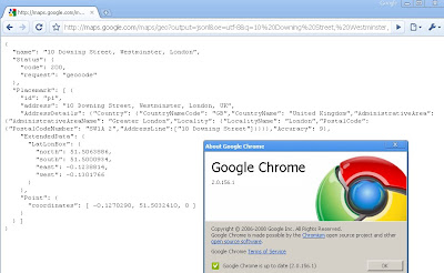
http://maps.google.com/maps/geo?output=jsonl&oe=utf-8&q=10%20Downing%20Street,%20Westminster,%20London&gl=uk&key=ABQIAAAA5heAddVpewIi0Vy-FvLfBBQ6SKP0Jc9Qt0dvx

now returns:
{
"name": "10 Downing Street, Westminster, London",
"Status": {
"code": 200,
"request": "geocode"
},
"Placemark": [ {
"id": "p1",
"address": "10 Downing Street, Westminster, London, UK",
"AddressDetails": {"Country": {"CountryNameCode": "GB","CountryName":
"United Kingdom","AdministrativeArea": {"AdministrativeAreaName":
"Greater London","Locality": {"LocalityName": "London","PostalCode":
{"PostalCodeNumber": "SW1A 2","AddressLine":["10 Downing Street"]}}}}
,"Accuracy": 9},

"ExtendedData": {
"LatLonBox": {
"north": 51.5063886,
"south": 51.5000934,
"east": -0.1238814,
"west": -0.1301766
}
},
"Point": {
"coordinates": [ -0.1270290, 51.5032410, 0 ]
}
} ]
}

Why the fuss?
Well now this extra [Extended information] can be used to set zoom levels for your map.

"Now, in the KML/JSON outputs, you'll also get information about the
recommended bounding box associated with a geocode. You can then use
that along with map.getBoundsZoomLevel(GLatLngBounds) to set an
appropriate center and zoom after a geocode. "

Available
"in the HTTP Geocoder output and JS/Flash Geocoder functions."
Not Available currently in the static api.

Source:
http://groups.google.com/group/Google-Maps-API/browse_thread/thread/b95422a18f8701ed?hl=en#

Well Done Google Map API Team


Potential Future Requests
Altitude (feet or metres)
Time Zone (+1GMT -7 GMT etc)
Standardize the output between formats
Translate place names (Local >English or English to Local)
Accuracy of Rooftop geocoding response
Sea/Ocean Geocoder (Atlantic, Black Sea etc)


Labels: , , , ,

06 January 2009

What's Coming in ArcGIS 9.3.1?

What's Coming in ArcGIS 9.3.1?

ArcGIS 9.3.1 is likely to improve the performance of dynamic map publishing and increases the sharing of geographic information.

High-Performance Dynamic Map Publishing

New faster rendering engine
  • Outperforms equivalent ArcIMS services.
  • Produces significantly better-looking maps.
  • Shortens map caching time.
  • Quicker, smoother zoom and pan.
* New Map Optimization toolbar in ArcMap helps you tune-up your map documents before publishing to ArcGIS Server.
  • Review and respond to errors, unsupported content, and warnings about items that will slow down your dynamic map services.
  • Preview your optimized map document and estimated rendering time.
  • Save your optimized map document to the new Map Server Document (.MSD)

Better Sharing of Geographic Information

* Better sharing of layers through ArcGIS Online
  • Layers can be packaged and published through ArcGIS Online Web services.
  • Layers can be found through a Web search.
  • Contributors can organize and control access to the layers they share.

Enhanced Support for Java Developers

* Ability to create the following extensions:
  • custom geoprocessing tools
  • server object extensions (SOEs) for ArcGIS Server
  • class extensions for custom behavior
  • custom renderer's for customized rendering of data
  • plug-in data sources
  • custom layers
* Support for Eclipse integrated development environment (IDE)
  • wizards to generate boilerplate code based on the developer's specification
  • autodeploy feature
**Upgrading to ArcGIS 9.3.1 does NOT require uninstalling ArcGIS 9.3**

Easy to migrate or work in mixed environments of ArcGIS 9.3 and ArcGIS 9.3.1 within the same organization since geodatabases, map documents, and APIs do not change.

When?
ArcGIS 9.3.1 is scheduled to be available in Q2 2009.

Source:
http://www.esri.com/software/arcgis/whats-new/whats-coming.html

Related:
http://webhelp.esri.com/arcgisdesktop/9.3/pdf/Whats_New_In_ArcGIS_93.pdf
(large pdf)

Existing Patches for ArcGIS 9.3 (SP1)

ArcGIS 9.3 SP1 (Desktop, Engine, Server) Geodatabase Replication System Version Patch
(December 17, 2008 - PATCH)

ArcGIS 9.x License Manager Update
(December 9, 2008 - PATCH)

ArcGIS 9.3 Service Pack 1
(November 24, 2008 - SERVICE PACK)

ArcGIS 9.3 SP1 (Desktop, Engine, Server) Topology Validation Patch
(November 19, 2008 - PATCH)

Military Overlay Editor 9.3 Service Pack 1
(October 17, 2008 - SERVICE PACK)

http://support.esri.com/index.cfm?fa=downloads.patchesServicePacks.listPatches&PID=43&FilterPV=457&FilterType=8%2C5

ESRI Wiki - System Requirements
http://wikis.esri.com/wiki/display/ag93bsr/ArcGIS+Desktop

Labels: , , , , ,