->

28 May 2010

Spacebits.eu Launch Map

Spacebits.eu Launch Map (Live Tracking on 30th May 2010)

Spacebits1 live tracking map
The Launch and Tracking Dashboard.
This will be the Live Dashboard for the official launch of Spacebits 1 which is scheduled for the 30th of May, 2010, 11AM UTC/GMT+1.

Time of launch on other cities in the world.

  • 03:00AM Los Angeles USA
  • 06:00AM New York USA
  • 07:00PM Tokyo, Japan
The Project
"The goal for this project is to launch an High Altitude Balloon (HAB) with a computer probe to near space in Portugal. The Helium filled Balloon will go as high as 30.000 meters (that's about 100.000 feet), to the stratosphere, then explodes and the probe falls with a parachute and is recovered on earth."

Location of Launch
Scheduled for launching the Balloon on 30th of May, 2010 at Castro Verde, Portugal.


Ver mapa más grande

For much more information on the Project please visit http://spacebits.eu/

The Live Map will be here http://spacebits.eu/live (a demo mode is currently available).

Setup - http://spacebits.eu/page/spacebits1live.html

Good Luck to the Spacebits1 launch. follow on http://twitter.com/flyspacebits

Labels: , , , , , ,

25 May 2010

ParkInfo.org Parks and Recreation Sites

ParkInfo.org - Exciting New Cartography for Web Access to Parks and Recreation Sites

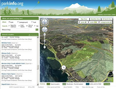
ParkInfo.org Full Parks Info in 3D
View Data from 3d ParkInfo.org combines the cartographic and the terrain to produce highly effective visualisations of the campgrounds and park boundary information.

The non-profit www.greeninfo.org Network has just put up a new version of its ParkInfo web site, offering up some great web map cartography that shows every public parks and protected open space in California, along with nifty integration of Google Maps API and Open Street Map data, Google Earth overlays, multiple search tools and more.
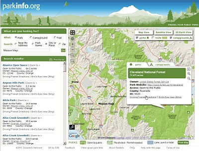
ParkInfo.org Map Parks
Full information on Parks, Campground at a click of a button.

ParkInfo uses the California Protected Areas Database (CPAD), a comprehensive and highly accurate GIS data set of everything from neighborhood tot lots to vast federal wilderness areas, almost all mapped to official property ownership boundaries. GreenInfo Network, which works for public interest groups on a wide range of GIS and information technology projects, maintains the 49 million acre, 15,000 unit CPAD database. CPAD is available for non-commercial use at www.calands.org , and has been developed with ESRI ArcGIS software.

The web site features the CPAD lands that are open to public use (some require a permit). The site lets users search near an address, by park or city name, or in a zip code. Search results show as lists and on the map and all parks on the map are clickable with more information - including a direct web link, driving/transit directions (via Google Maps Directions) and a link to Bing's Birdseye view of the site. The web map can also be enlarged to full screen to take advantage of the great cartography.

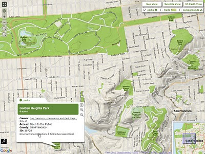
GreenInfo shifted from using Google's Streets view to its own custom MapView, which features 10 meter DEM data in an attractive hillshade and well-styled Open Street Map streets. When fully zoomed in, users also see contour lines. In addition to Satellite view, users can also easily browse all the ParkInfo data using the Google Earth plugin. ParkInfo also has all public campgrounds in the state and a selection of Open Street Map trails.
ParkInfo.org TopOSM Map
TopOSM terrain tiles have been used to show relief in 2D view for ParksInfo.org

Map tiles were created using the TopOSM scripts and rendering process created by Lars Ahlzen see http://toposm.com/usw/ for example. Areas, streets and labels are rendered using Mapnik. PostgreSQL with the PostGIS extension provides the spatial query capabilities for ParkInfo while a MapServer Web Map Service (WMS) GetFeatureInfo request returns park details when a user clicks on a park.

View the Map in 2D and 3D - http://www.parkinfo.org/

ParkInfo can be adapted into other organizations and agencies' web sites, allowing them to offer full search of public recreational opportunities. The State of California Department of Parks and Recreation has already done so at http://Findrecreation.parks.ca.gov

Composed by Larry Orman from http://www.greeninfo.org/ with thanks from Mapperz
GreenInfo is exploring an API as well as expanding ParkInfo to other U.S. states. Contact them at: parkinfo@greeninfo.org

Labels: , , , , , ,

21 May 2010

Google Maps API Styled Map Wizard

Google Maps API Styled Map Wizard
*change Google Maps to suit your website colours and style.

Google Maps are instantly familiar by users interface the familiar look and feel of Google maps on any web site. All that can now change thanks to the Google Maps API v3 Style Wizard.

Google Maps API Styled Map Wizard bad carto
Make really bad colours if you want


Google Maps API Styled Map Wizard better carto
or something slightly more cartographically acceptable.

Use this http://gmaps-samples-v3.googlecode.com/svn/trunk/styledmaps/wizard/index.html
If you want your map to stand out from the crowd, your options are limited to customizing the markers and controls, and if your brand has a particular colour scheme that is reflected on your site, Google Maps may not sit well with it.

"You are now free to unleash your creativity on the base Google map itself, as we are delighted to launch Styled Maps in the Google Maps API v3."

Styled Maps offers you control over both the types of features shown on your maps, and the colour scheme used to represent them. The possibilities are endless....

See more Examples here:
http://maps-api-tt.appspot.com/apilite/styled/styled.html

Source:
http://googlemapsmania.blogspot.com/2010/05/add-style-to-your-google-maps.html
Official Post:
http://googlegeodevelopers.blogspot.com/2010/05/add-touch-of-style-to-your-maps.html

Labels: , , , ,

19 May 2010

Bye Bye Google Maps API v2 - V3 Graduates

Bye Bye Google Maps API v2 - V3 Graduates

was coming sooner or later...

As part of the Google Maps API v3 graduation to the principal maps API Street View has been added to the Maps API v3.

Street View in v3 is entirely implemented in HTML in order to accommodate all of the mobile devices on which v3 is supported. In v2 of the Google Maps API Street View relied on Flash.


Streetview now available in V3 of the Google Maps API (drag pegman to active the HTML version of Streetview)

In order to ensure that existing Maps API v2 applications can be migrated to Maps API v3, we have also been striving to add all of the most popular v2 features to v3. As part of that effort we are also happy to announce that Street View is now available in the Maps API v3.

When you use Street View in v3 you will notice a number of differences with v2. The most significant change is that Street View is entirely implemented in HTML in order to accommodate all of the mobile devices on which v3 is supported. We have also added Pegman support to the map, and a number of new features, including markers, infowindows, and custom imagery.

In conjunction with the graduation of the Maps API v3, we are also announcing the deprecation of the Maps API v2 and Mapplets (which is based on v2). These deprecation announcements confirm that no further feature development is planned for these two APIs. However, we will continue to maintain and support applications using these APIs for at least three years consistent with the deprecation policy detailed in the Maps API Terms of Service.


Sources:
http://googlemapsmania.blogspot.com/2010/05/google-maps-api-v3.html

Links:
http://googlegeodevelopers.blogspot.com/2010/05/they-grow-up-so-fast.html

Labels: , , , , ,

18 May 2010

10 Years of GPS: Where Next?

10 Years of GPS: Where Next?

Constellation GPS Satellites
In the 10 years since the USA military was ordered to unscramble the GPS signal, the big benefit has been to increase accuracy from about 20+m to less than a few metres.

"Global Positioning System (GPS) is a space-based global navigation satellite system that provides reliable location and time information in all weather and at all times and anywhere on or near the Earth where there is an unobstructed line of sight to four or more GPS satellites. It is maintained by the United States government and is freely accessible by anyone with a GPS receiver."

http://en.wikipedia.org/wiki/Global_Positioning_System

From SatNavs to Mobile phones GPS is integrating more and more into everyday lives. But will the car self drive you to the petrol station when the tank is almost empty? Will the bike tell you the nearest location to clean/fresh/tap water?

Using GPS in the future will be interesting gearlog says:
Predictive swiveling headlamps. "On higher-end cars, the headlamps swivel lift and right when you turn the wheel. With more accurate GPS, the car would start to turn the headlamps a second or two before the road curves. That adds a small measure of safety. Plus, on a dark country road at night, sometimes it's hard to recognize if you're seeing the road marking cuangled white rail fence 20 yards off the highway. The
headlamps could help show you the way."
http://www.gearlog.com/2010/05/10_years_of_unscrambled_gps_th.php#more

GPS handset for the visually impaired

"
The 3D map of the city is lifted up from the surface of the device and moves as you move, like a compass and with zoom, search, voice command, and everything. All in your palm. "
GPS handset for the visually impaired
http://www.yankodesign.com/2010/04/22/gps-in-a-hand-disk/

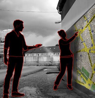
Tam Tam GPS Flashlight

Personal Navigation with the ability to project your own custom route on the pavement or wall in front of you.
GPS projector map concept

http://www.gizmag.com/tamtam-gps-flashlight-concept/14284/

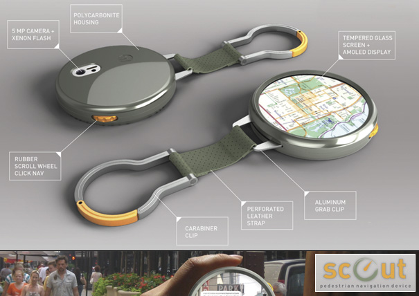
Or the Scout – Portable Pedestrian Navigation Device
Intended to be used by people traveling about, connecting then with local knowledge, wisdom, and GPS information to guide them. It’s a digital compass is what it is. It encourages “uninhibited exploration, discovery, documentation, and sharing.”
Pedestrian Navigation Device
http://www.yankodesign.com/images/design_news/2009/12/02/motobook01.jpg

How to power and maintain it all.
But the huge advances in powering and maintaining these devices (power cells, solar, wind charging etc) will help users no end with the previously frustrations of running out of power for the many devices that are out there to be consumed.

Labels: , , ,

12 May 2010

Google Maps API v3 New Features

Google Maps API v3 New Features

3 New Features have arrived at the V3 Google Maps API


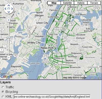
  1. KML Overlays
  2. Biking Directions (selected USA Cities currently)
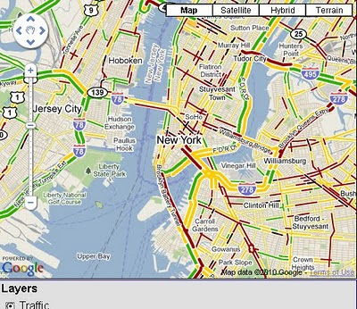
  3. Traffic Layer
KML Overlay Google Maps API v3
Google Maps API v3 now supports overlaying of KML files.

Bike Routes Google Maps API v3
Bike Routes are now enable for overlay for Googel Maps API v3 in selected cities across the United States.

Traffic overlay Google Maps API v3
Also Traffic Overlay is now available for use on v3 of Googel Maps API

You maybe interested in 'Boxer Router'
http://googlegeodevelopers.blogspot.com/2010/05/search-along-route-made-easy-with.html
credit to

and
Marker Manager 1.0 for v3
http://googlegeodevelopers.blogspot.com/2010/04/markermanager-10-manage-your-markers-in.html
credit to )

source with documentation
http://googlegeodevelopers.blogspot.com/2010/05/kml-traffic-and-bicycling-layers-come.html

Labels: , , , , , ,

10 May 2010

Global Action Atlas by National Geographic

Global Action Atlas by National Geographic

Global Action Atlas by National Geographic. The application allows users to peer into areas where our planet needs help. National Geographic and Bing Maps invite you to support efforts across the globe to help people in need, protect plants and animals, usands of others who are donating, volunteering, and sharing knowledge on behalf of community-based projects working to solve global challenges.

National Geographic Global Action Atlas Bing Map
"The Global Action Atlas spotlights hundreds of local, cause-related projects from around the world to a large audience of concerned citizens, giving individuals opportunities to take action by donating, volunteering, advocating, and sharing information. The Atlas enhances and extends the mission of the National Geographic Society"

Themes of interest include Conservation, Humanitarian Affairs, Cultures, Exploration, Climate Change and Energy.

Global Action Atlas

  • Conservation: Includes categories on animals and plants; fresh water; landscapes; migrations and corridors; and oceans and coastal areas.
  • Climate Change: Focuses on projects having to do with forest conservation and management; renewable energy; reforestation; and ocean impacts.
  • Cultures: Features projects focusing on preserving endangered languages; cultural preservation; archeology; and indigenous rights.
  • Energy: Focuses on technology; energy efficiency; and energy investment.
  • Exploration: Focuses on taking action to help preserve our planet; to explore its mysteries through sustainable travel; and to raise awareness about cultures and environments, and science and adventure projects.
  • Humanitarian Affairs: Includes projects focusing on water and sanitation; emergency relief; health; education; empowering women; and poverty and hunger.

View the Global Action Atlas - http://www.actionatlas.org/map

source:http://www.bing.com/community/blogs/maps/archive/2010/05/10/new-bing-maps-application-global-action-atlas.aspx

Labels: , , ,

05 May 2010

UK Election Map #ge2010

UK Election Map #ge2010
UK Election Geo.me tweets map

View live geotagged tweets over a constituency map of Britain. Recent geotagged tweets are shown, so the tweets you see have been sent from the actual locations shown.

Twitter Controls: Use the yellow search box to search for specific terms. You can disable automatic reloading, force a reload and clear the map using the panel controls. Loading status and popular hash-tags (#geo2010) are shown at the bottom of the panel.

Constituency Data: the constituency map uses the new 2010 boundaries released as Ordnance Survey Open Data, coloured by the notional 2005 election results, as provided by the Guardian Data Store. Zoom closer to see constituency names. Boundaries for Northern Ireland constituencies are not yet available as open data.

Important Note: the map shows only properly geotagged tweets, made by users who have enabled this feature. This represents only a small proportion of all tweets.

UK Election Map
http://www.geo.me/election

source:
http://googlemapsmania.blogspot.com/2010/05/uk-election-on-google-maps.html

Labels: , , , , , , ,

03 May 2010

Guest Post: Opening of British Library Magnificent Maps Exhibition

Guest Post: Opening of British Library Magnificent Maps exhibition
A Special Guest Post by Steve Chilton Manager of e-Learning Academic Development at Middlesex University & Chair of the Society of Cartographers
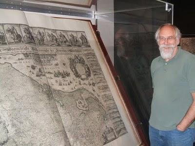
Steve Chilton with the Klencke Atlas
Steve Chilton with the huge six-by-three feet (0.9m×1.9 m) when closed, Klencke Atlas.

The great and the good (plus myself) met in the grand foyer of the British Library for the opening of the Magnificent Maps exhibition. Guest of honour was Python Terry Jones who reckoned he got the gig because he had once managed to carry off hosting a 4 hour radio programme on Medieval Maps. He recounted stories of learning about maps when playing at being soldiers in his school days. This included getting the coords completely wrong and sending the whole troop to the wrong locations when he was NCO.
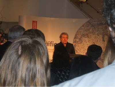
Terry Jones Opening the Magnificent Maps exhibition

Terry Jones (from Monty Python) Opening the Magnificent Maps exhibition.

He also got a dig in at Satnavs – suggesting they were equivalent to reading a book on a selection of cards with one word on each. When discussing the Mappa Mundi he also reminded us that the original translation of mappa was tablecloth – which had some resonance later when we viewed the exhibition and saw the immense size of some of the exhibits and the materials they were produced on. He had a nice line in blaming Washington Irving for the whole flat earth movement, because (as biography of Christopher Columbus) Irving introduced the erroneous idea that Europeans believed the world to be flat prior to the discovery of the New World, and this was taught to American schoolchildren for generations.

Following the speeches, and previously a little wine and canapés, we were invited to view the exhibition. It is housed in a series of 10 rooms or settings, which attempt to place the exhibits in themes that reflect their original purpose or location. The publicity claims that “beautiful and valuable maps have adorned walls since Roman times and even earlier, making statements about their owners’ power, taste and influence”. There are certainly some beautiful maps on display, and some apparently that are rarely available to view, and allegedly one that has just been discovered in the vaults after 500 years (exactly how do they know it has not been out for that long? but no matter). The settings include an audience chamber, a merchant’s house, a schoolroom, and a bedchamber. I looked at as much as possible in the exhibition, but was inhibited by two factors.

Firstly there were a lot of people in the way, and I really wanted a private showing!Secondly, and more seriously, there is just so much to see that I am going to be going back at least one more time (and possibly more) to take in more of the details.

For the moment I will just share six first impressions that I noted down that particularly interested or intrigued me. In no particular order they were: a map of Marco Polo in Asia – with a magnifying glass that you physically moved around but which was actually just a digital place marker to tell the software which bit to enlarge (it was projected onto a tablet); a map of Canton for Foreigners painted with distemper; a large set of room dividing screens covered in detailed maps; the detail in Stephen Walter’s London for Insiders map; the relief depiction on Carte de la Frontiere Turco-Persane; and the woodcut Birds Eye View of Venice from 1500.

I took (with permission) a picture of myself by the huge Klenke atlas, which you normally pass closed up in the foyer to the BL Map Room, and which is now open on a double page spread for study and is mightly impressive, allegedly the largest atlas in the world. If you have been watching the BBC4 maps series you will have seen three men carefully moving this exhibit from it’s normal to it’s temporary location. Every single exhibit is worthy of it’s place, and truly reflects the magnificent holdings of the British Library. You do just wonder what more treasures there are in the other 4.5 million maps in the BL that aren’t on show here. Working on a research project on early OS maps in the BL Map Room for over a year now I have sometimes seen curators Peter Barber and Tom Harper bring out sample maps to lay out and discuss for possible inclusion, and have not been able to resist looking at them curiously (the maps not the curators!). The aforementioned curators have also compiled an excellent book linked to the exhibition, which is now awaiting my attention.

Along with the recent BBC Radio 4 programme with Mike Parker (who told me he is about to do a trailer for the BL exhibition in Welsh for Radio Wales), the two recent BBC TV programmes, this exhibition really brings maps to the public in an accessible way. As noted I shall be going back to revisit it, and really consider it a must visit experience for all cartophiles.

Sources:

Link to exhibition : http://www.bl.uk/magnificentmaps/

Link to exhibition blog: http://britishlibrary.typepad.co.uk/magnificentmaps/

Link to photo of Terry Jones: http://twitpic.com/1jgix2

Link to photo of Klenke atlas: http://twitpic.com/1jgiqx

Many thanks to Steve for sharing his experience of the British Library Magnificent Maps Exhibition.

Labels: , , , ,