->

31 March 2009

South Downs National Park Maps

South Downs National Park Maps
New 'South Downs National Park' - Confirmed
The new South Downs National Park - Overview [image for illustration]

On 31st March 2009 this has now be confirmed.

http://www.defra.gov.uk/wildlife-countryside/protected-areas/national-parks/south-downs/index.htm


Maps of the new National Park
http://www.defra.gov.uk/wildlife-countryside/pdf/protected-areas/national-park/south-downs/boundary-map.pdf

Western Section [Maps 1-11 & 41-49]
Central Section [Maps 11 -20 & 34-40]
Eastern Sections [Maps 20 -33]

Beachy Head - http://www.naturalengland.org.uk/Images/Map%2027_tcm6-10384.pdf

More South Down National Park Annex Maps
http://www.planning-inspectorate.gov.uk/southdowns/documents/PositionPapers.htm

Decision Letter [No Maps]

GIS data is available - http://www.gis.naturalengland.org.uk/pubs/gis/GIS_register.asp
[In Shapefile Format]

In the News
http://news.bbc.co.uk/1/hi/england/7973417.stm
http://www.guardian.co.uk/environment/2009/mar/31/south-downs-national-park

Labels: , , , ,

30 March 2009

Crown of the Continent - National Geographic Maps

Crown of the Continent - National Geographic Maps

"Part Map, Part Guide Book"

National Geographic GeoTourism - MapGuides

Crown of the Continent uses National Geographic Custom Maps that utilizes Google Maps API as the mapping engine.

"The purpose of the project is to promote geotourism, or tourism that helps protect wild places, according to James Dion, associate director of the National Geographic's Center for Sustainable Destinations."

View the Maps
http://www.crownofthecontinent.net/map_search.php

PDF Guide:Geotourism MapGuide
http://www.nationalgeographic.com/travel/sustainable/pdf/geotourism_mapguide.pdf

Suggestion - can that nice map be expandable - full screen please.

Source:
http://www.msnbc.msn.com/id/29956194/

Labels: , , ,

28 March 2009

Street Tours - Street View New!

Street Tours - Street View New!


Map Channels have been busy once again and produced a handy set of tools where you can record Google Street View sightings in your own custom map and then embed on to your website.

"Create your own mapped Google Street View tours - embed onto your website"


Street View Tours - Coverage Availability
Blue areas indicate where Street View is currently available.

Future coverage are likely to expand for the UK and new areas such Germany, Belgium and Canada will be introduced.

related links:
http://streetcities.com/Main.aspx
http://www.mashedworld.com/Home.aspx [Street Tours available here]
http://www.mapchannels.com/DualMaps.aspx

Labels: , , ,

26 March 2009

Cartifact Maps (Beta)

Cartifact Maps (Beta)

Cartographic Maps made available with Cartfact Labs and Google Maps API.

Cartifact Maps Custom Map Beta
Take Google Maps and add your own custom tiles, integrate local search, historic maps (1880, 1928 & 1981) and you get a nice cartographic mashup.

"Our goal to create a visually enhanced environment for custom cartography focuses on Los Angeles for this beta release."
Bruce Daniel

Director, Cartifact Labs

Cartifact Maps Historic Map Zoom Zens - Local Search
Lens Zoom - can display historic, Google maps/aerial of Cartifact's own custom tiles.

Additional Feature
s:
Lens control (see image above) - no need to zoom in - the lens does the work
Local searches on Hotels, Residential Properties and Commercial Spaces.
Drag zoom.

Try the Cartographic Mashup - http://maps.cartifact.com/

Mission
Cartifact Labs’ mission is to identify, explore and provide expertise in emerging technologies related to the creation and use of maps.

Labels: , , , , ,

24 March 2009

Nokia SportsTracker v2.05 with Maps

Nokia Sports Tracker v2.05 with Maps

Finally Nokia makes the map option available in the Sports Tracker Application
Nokia Maps v2.05 - With Maps
Image source:
http://nokiae71.wordpress.com/2009/03/23/the-best-now-even-better-nokia-sports-tracker-205/

Phone - Map Options - Source
Maps are available - though the Phone option does not use Nokia Maps (v2 or v3) data to display but rather downloads tiles (similar to web based maps).

Not sure if that is a good thing, Would rather have preloaded tiles on an area - due to out of network issues with walking, hiking, cycling in rural areas.

But at least the maps have made it to this application- after a long and a number of submitted requests.

Only 'Map Tiles' available - no Satellite or Terrain option (unlike the Nokia Maps)

The fastest way to get it is connet to a wifi source and use the 'check for updates on the phone.
Or Download it from here
http://sportstracker.nokia.com/nts/mobile/downloadclient.do?p=50&hw=536926806
(link is a direct link to the file SportsTracker_50_v205.sisx)

Sports Tracker GPS fix quality
GPS Fix strength/quality is viewable (map has no data in this area) and will also replay your routes.

http://betalabs.nokia.com/blog/tag/sports-tracker/

Suggestion - Terrain maps would be useful.

Labels: , , , ,

22 March 2009

OpenStreetBrowser [View Maps & Metadata]

OpenStreetBrowser [View Maps & Metadata]

OpenStreetMap Browser - Metadata Viewer
OpenStreetBrowser allows anyone to view the information behind the tiles of OpenStreetMap.

Metadata - Information about data (including history)
http://en.wikipedia.org/wiki/GIS_metadata

Viewing Metadata - Oxford Street - London
Viewing metadata of Oxford Street - the useful information within.

"Openstreetmap (OSM) is growing and attracting more and more users contributing to the project (over 100,000 users now!). It's all about collecting and mapping geospatial data, which we submit to the database. But wait, to be honest: Without visualizing the data - without maps - openstreetmap is not much fun. For most new users the Slippy Map is the first map to see from openstreetmap. I believe, that many of us were motivated to become contributors because of this slippy map, because of the moments we wait our recently submitted information to pop up on Mapnik or Osmarender tiles. Although I love our slippy map, it just visualizes a tiny bit of information which is now available from our openstreetmap-database. So, when I first discovered the project Openstreetbrowser by users, I was thrilled: It's fun to use the Openstreetbrowser. The map looks great and I feel, that the authors made every effort and did a lot of thinking on details to create the Openstreetbrowser."
source: http://osmbonnblog.blogspot.com/2009/03/browsing-openstreetmap-v20.html

So now we have an Online Style Editor - CloudMade
We have the Online Editor - OpenStreetmap
Now we have the Online OpenStreetBrowser.
Can these merge to be come a 'one-stop' location for users?


**Note Data outside Europe is not currently available in OpenStreetBrowser - this may change in the future of this project.

Previous Related Posts:
http://mapperz.blogspot.com/2009/03/cloudmade-map-editor.html
http://mapperz.blogspot.com/2008/09/open-street-map-in-shapefile-format.html

Labels: , , , , ,

21 March 2009

UK - Street View Plus

UK - Street View Plus

UK street view plus
View the new Street View images along with Birds Eye View in sync.

Use the Streetview window or Map - Car Icon is draggable - interactively updates your movement in each window.

Created with Map Channels Dual Maps - Free mapping tools for your website or blog.

Thinking: 1:50,000 - 1:25,000 Ordnance Survey Mapping pending Multimap 'Terms and Conditions'

http://mapperz.googlepages.com/Marble_Arch_Streetview_Plus.html

Related post:
http://googlemapsmania.blogspot.com/2009/03/street-view-plus.html

Developer note:
Bug: the svb (StreetView Bearing) is currently unavailable [users can still manually rotate the streetview images], Map Channels is informed and they are currently finishing another project but there is likely to be an update to this in the near future (plus enhancements)
please see:
Src Parameter Name: svb on this (at the bottom).

Labels: , , , ,

18 March 2009

Google Street View UK Launched

Google Street View UK Launched

Official Post on this:
http://google-latlong.blogspot.com/2009/03
/street-view-cures-homesick-blues.html

See 'Street View Plus' in action
http://mapperz.googlepages.com/Marble_Arch_Streetview_Plus.html
blog post:
http://mapperz.blogspot.com/2009/03/uk-street-view-plus.html
recommended by:
http://googlemapsmania.blogspot.com/2009/03/street-view-plus.html

Update 19/03/2009
A First UK Google Street View Mashup? "A Quick Drive Through Clifton Bristol"
**now mentioned on the The Guardian by Richard Wray**

Bristol Google Street View UK By Mapperz
http://mapperz.googlepages.com/Bristol_StreetView_UK.html
"On the way in to the UK launch of Street View, Kudos to @Mapperz for the first Mashup within a hour !"
Google's Geospatial Technologist
http://twitter.com/edparsons

Google UK StreetView Launched
http://maps.google.co.uk/ and drag pegman on the map


View Larger Map

Mapperz

Labels: , , , ,

16 March 2009

Street View Canada [MapJack]

StreetView Canada [MapJack]
Streetview Canada - Vancouver

MapJack does it again and is the first to provide 'StreetView' for Canada


"Vancouver, Whistler, or Squamish in British Columbia, the only three areas that offer Street View at today’s launch. The company plans to expand to include Street Views of Toronto and Montreal next, followed by as much of Canada as possible."

The link that will let you see MapJack StreetView in Vancouver...
http://www.canpages.ca/business/BC/vancouver/banks/961-064200.html
and click 'StreetView'
Full Screen Option available.

Only available via:
http://canpages.ca/
(currently not available via
http://www.mapjack.com/)


Mapperz Source:
http://krisabel.ctv.ca/post/Canada-AM-e28093-Street-View-Comes-To-Canada-With-New-Tricks-From-CanPagesca.aspx

related previous posts:
http://mapperz.blogspot.com/2008/03/streetview-mapjack-vs-google.html
http://mapperz.blogspot.com/2008/12/streetview-stockholm-mapjack.html

Labels: , , , ,

13 March 2009

English Lake District [3D Tours]

Lake District Information [3D Tours]

English Lake District  3D Map Helvellyn
"The site is intended to offer information about this area, in addition to providing maps, views and virtual tours of its villages, lakes and mountains. These are intended to enhance your appreciation and enjoyment of the Lake District."


The site also uses Google Earth to overlay walking routes in addition to information of mountain features on many of the Lake Districts Fell.

"This site uses the Google Earth Plug-in on a number of pages. This innovative software presents us with a fresh way of viewing the Lake District from a range of new perspectives. You can view 3d image models of the mountains and valleys, and take guided tours around the villages and lakes. You are also free to visually navigate around the district going wherever you choose. I have found this a great way to get to know Lakeland in intricate detail."

*Google Earth Browser Plug-in Required.

A good starting point

http://english-lake-district.info/virtual-tours/village-virtual-tour.html

A few tours (there are more...)

Lakes Tour

Villages Tour

Helvellyn Tour

The tours seems very smooth and works well with users.

More Info: http://english-lake-district.info/index.html

Labels: , , , , ,

12 March 2009

UMapper Routing

UMapper Routing

The video shows all the new and clever functions of the New Routing system implemented by UMapper


"After weeks of development and some rigorous testing, the new *Routing Tool* is available in the UMapper map editor. The new tool makes it easier than ever draw complex, multi-point routes. In a matter of seconds you can map your walk or drive without manually tracing each step. Once a route is created, it can be unlocked for further editing."

One the back-end, UMapper are using the powerful MapQuest routing service which is currently available in the United States, Canada, Australia, New Zealand and most of the Western Europe. More geographies are coming soon.

Also there is a new plugin for wordpress bloggers wanting maps on their blogs
http://wordpress.org/extend/plugins/umapper/

New version includes:
  • New provider added - Yahoo!
  • You can now import your feeds directly into map editor - acceptable formats are KML, GPX, GeoRSS
  • Link Data Feed
  • I18n support - currently work in progress (support for Russian language was added for beta)
  • WordPressMU is truly supported - just enter UMapper Integrator's Key as site admin and all your hosted blogs would be able to interact with UMapper.com - no other keys are required!
  • By popular request: custom map sizes are now available!
  • Ability to delete maps from within plugin w/o visiting UMapper site
  • Rewritten UI, should make map creation much more simple.

Supported map providers:

* Microsoft Virtual Earth
* Google Maps
* OpenStreetMap
* Yahoo!

Labels: , , , , ,

11 March 2009

Mapping the News API (Guardian)

Mapping the News API

The Guardian is now Geocoding/Mapping it's News Articles with it's New OpenData APIMapping the News API - Guardian

A neat way of finding news articles by location.

Experiment with the new API
http://www.guardian.co.uk/open-platform/getting-started

Start Page for Guardian Map API
http://guardian.apimaps.org/index.html

GeoCode this! (try a search term)
http://guardian.apimaps.org/search.html

CloudeMade Mapping
http://guardian.apimaps.org/map.html


Note: Articles that do not have a location can be updated by readers

Example search
http://guardian.apimaps.org/search.html?q=London

For Budding Developers:
Data Structure of the API
http://guardian.apimaps.org/data.html

Map API integration:
News articles by The Guardian.
Maps © 2009 CloudMade, map data CC-BY-SA OpenStreetMap.org contributors.
Place searching by Flickr. Font reset by YUI. Cheerleading by SteveC.
Design and code by Stamen Design.

Source:
http://www.programmableweb.com/mashup/guardian-api-maps

Labels: , , , , , , ,

10 March 2009

"The Big Apple on the Mumbles"

"The Big Apple on the Mumbles" - Map Text (errors)
View map of Mumbles, Swansea, West Glamorgan, Wales, SA3 5 on Multimap.com
Get directions to or from Mumbles, Swansea, West Glamorgan, Wales, SA3 5
"The Big Apple on the Mumbles" is an admitted 'software' error...

"Microsoft has said a technical glitch was responsible for the unusual road name
It is a quirky landmark well know to visitors to Mumbles near Swansea. "
BBC News(Wales)

"A spokesman for Microsoft said it was a minor technical issue with its mapping software but that maps were updated regularly and it would be amended."

"The Big Apple kiosk at the entrance to Bracelet Bay has stood near Mumbles Pier for decades - selling ice cream, refreshments and buckets and spades during the summer. "

Source & More Info:BBC News

Labels: , , , ,

03 March 2009

CloudMade Map Editor

CloudMade Map Editor

update 05/03/2009
CloudMade feedback (see comments) looks promising. Thanks for the kind remarks, always willing to help a brilliant minded concept.

Ever wished you can create your own style of map online?
Well CloudMade Map Style Editor might be what you have been waiting for.

"Tired of the same old maps? CloudMade's Style Editor lets you create customized cartography that you can use to distinguish your applications. With the Style Editor, you can easily create a unique map style in a matter of minutes without having to install any special software or have any previous cartography experience"
source:Cloudmade

It uses data from Open Street Map, then allows a logged in user to edit the colour of Roads, Points of Interest [POI], Area features.
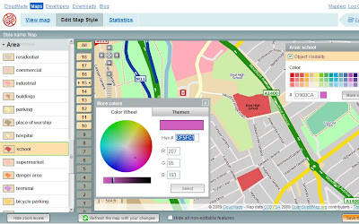
Cloudmade Editor School colour picker
Selecting and editing colours is made easy using this CloudMade Map Style editor.

But what happens if you want different representations of a feature at different scales?
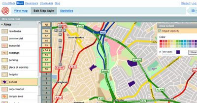
Cloudmade Editor School colour picker - Zoom Levels
Note the zoom scales selected, at these scale you will see a strong purple representation, zoom in and it will be transformed into a more subtle colour (this is only for demonstrating this technique).

Mapperz wish list: (now this is just a very short version)
  • Edit Fonts (Annotation) but notoriously difficult to implement
  • Text Placement, Centre, North,South,East,West placement of point/symbols with text.
  • CMYK colour picker option (for printer), RGB and Hexidemical colours only useful for Screen/Web. See ColorBrewer for this type of usefulness.
  • Polygon to Point Representation [e.g.When a School is at an unsuitable scale for area representation is can be displayed by a point/symbol instead)
  • Preview/Outline Mode (with Auto Refresh) - currently the user requires to click 'refresh the map with your changes' button. Outline mode for seeing the nodes and segments. Similar function is in Adobe Illustrator.
  • Reorder Layers, ranking structure - sometimes having polygons above features can be useful, like a masking out polygon.
  • Export File like Illustrator. (maintaining styles and line widths with attributes).
  • Grid or Graticule Option.
  • Fix the Help [http://www.cloudmade.com/site/products%2Fstyle-editor%2Fhowto] The requested URL /site/products/style-editor/howto was not found on this server.
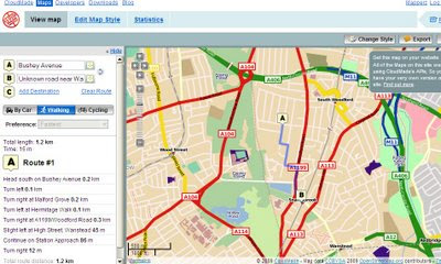
CloudMade Custom Map Directions
And finally you can already add routing/directions to you customised map, this is because the underlining data has not been changed. Only the graphical representation of the data has been customised.

This is just one of many products CloudMade is offering - here is a full list of all.
http://cloudmade.com/products


Some have already created their own map styles, this are available to view
http://cloudmade.com/products/style-editor/gallery


Below is Mapperz first attempt at showing the schools changing colours when zooming in.


Labels: , , , , , ,