->

20 April 2011

Ovi Maps 3D Beta (Now Photorealistic)

Ovi Maps 3D Beta ( Now Photo-realistic)


Cities coverage

Nokia's photorealistic 3D models of metropolitan areas initially include:

- Barcelona
- Boston
- Chicago
- London
- Copenhagen
- Florence
- Helsinki
- Las Vegas
- Los Angeles
- Madrid
- Miami
- Milan
- New York
- Oslo
- Prague
- San Francisco
- Stockholm
- Toronto
- Venice
- Vienna

http://maps.ovi.com/3d/
(plugin required) - servers are in demand currently and might not get the full picture - wait a few days for the hype to calm down.

http://conversations.nokia.com/2011/04/19/ovi-maps-3d-the-world-is-not-flat/

Labels: , , , , ,

10 February 2010

New York Times - 3D Olympic Venues Map

New York Times - 3D Olympic Venues Map

If you want just one map to locate events for the Winter Olympics in Vancouver 2010 then this Interactive and Animated 3D Map created by The New York Times is it.

New York Times Olympic Venues Mapped - 3D Animated
  • Highly Detailed
  • Smooth Animated Zooms to Event Locations
  • Interactive (Users can control 3D aspects panning and zoom)
  • Informative Details on the Sport persons to look out for
  • High Quality Action Photographs.
Clicking from the Map above smoothly zooms to:
New York Times Olympic Venues Mapped - 3D Animated Bobsled
Users can control Aspect using the controls in the top right corner.

New York Times Olympic Venues Mapped - 3D Animated Halfpipe
Using Flash there is a quick response to load up a very impressive 3D Animated Map

Well done to
SHAN CARTER, MATTHEW ERICSON and JOE WARD; Additional reporting by Melissa Hoppert


Sources: Elevation data by Intermap Technologies Inc.; satellite photographs by Digital Globe, Province of British Columbia and TerraMetrics via Google Earth

Visit the New York Times - 3D Olympic Venues Map
http://www.nytimes.com/interactive/2010/02/09/sports/olympics/2010-olympics-venue-map.html


Labels: , , , , , , ,

12 October 2009

OS 3D Laser Map - Most Accurate Mapping Ever

The national agency used state-of-the-art laser technology and aerial imagery to create what it claims is one of the most accurate maps every produced.

"Ordnance Survey says that the results are substantially more accurate than the 3D maps available through online applications such as Google Earth and Microsoft Virtual Earth, and will revolutionise the way it charts the British Isles."

Video of Bournemouth's Seafront attractions


The Good News:

“Given the level of detail that we've [ordnance survey] achieved, I think Bournemouth can confidently lay claim to being the best mapped place on the planet.”
Glen Hart, head of research at Ordnance Survey

The Bad News:

The 3D mapping service will not be rolled to the rest of Britain for at least five years, while Ordnance Survey perfects the new method. The black dots in the video represent points where no laser data was obtained.

Full article and source:
http://www.telegraph.co.uk/news/uknews/6308577/Ordnance-Survey-3D-map-of-Bournemouth-is-most-detailed-ever.html

Labels: , , , , ,

22 June 2009

iPhone MobileNavigator [NAVIGON]

iPhone MobileNavigator [NAVIGON]

Navigon iPhone GPS Navigator
Now Available via iTunes Apps

"Turn your iPhone into a first-rate navigation system with MobileNavigator. Try the feature for yourself and enjoy the excellent user control and superior design that allow simple and intuitive operating. The application includes the latest map material from the market leader NAVTEQ and can be used without an Internet connection, which is of enormous benefit abroad, for example, as no extra charges are incurred. With MobileNavigator you can turn your iPhone into an equally handy and convenient route guidance system."

Features and range of functions:

  • 2D and 3D map displays
  • Can be used in portrait and landscape format
  • Precise voice announcements
  • Intelligent address entry
  • Reality View Pro (realistic display of motorway interchanges and exits)
  • Lane Assistant Pro
  • Real signpost display
  • Speed Assistant with adjustable audio-visual warning
  • Day and night mode for map display
  • Direct access and navigation to contacts saved in the iPhone's address book
  • The latest NAVTEQ map material including more than two million (EU version) places of interest (POIs)
  • Navigation is automatically resumed after an incoming phone call
  • Quick access to user-defined POIs in the area and along the route
  • Take Me Home function with a single click
  • Automatic language selection to match the iPhone's user language
Cost:
Navigon’s MobileNavigator Europe app (iTunes link) is now listed on the App Store for a one-time price of $94.99 [£58] but a note in the description claims that the “special introduction price is valid only until June 30th.”

Similar Products for Windows/PDA's

also S60 3rd Edition Phones

Source:
http://blogs.zdnet.com/Apple/?p=4220

Labels: , , , , ,

02 June 2009

3D Open Street Map

3D Open Street Map (Via Google Earth plugin +kmz)

Open Street Map in 3D using Google Earth plug-in - Fort William
With the help of Google Earth Plug-in and a KMZ from OSM Wiki is is now easy to combine

Open Street Map in 3D using Google Earth plug-in - SW England
View anywhere in the World with Open Street Map coverage.

Go play. Look at http://mapperz.googlepages.com/OSM_3d_seemless_GE.html
Note:Tiles do cache via Google Servers parsing the kmz file and is heavy on the browser.

Credit to markus-bader.de for creating the kmz file.

Related Post:
http://googlegeodevelopers.blogspot.com/2009/05/hey-maps-api-and-earth-api-developers.html

Labels: , , , ,

12 May 2009

Lake District Map - Updated +Heritage Paths Scotland Routes

Lake District Map - Updated + Heritage Paths Scotland Routes

The Lake District Map [3D] has been updated making over 70 different camera views available using a familiar nested link structure. User will find it a good way to explore the different features in the area.

Lake District Map Updated
Fly through tours guide you around the Fells, Lakes, Valleys and Villages of Cumbria, England.

Source: Email from Justin Farrell (Lake District Map Author)


Heritage Paths for Scotland

Another map has just been released from the Heritage Paths covering Scotland
(Heritage Paths Project - ScotWays - Scottish Rights of Way and Access Society)

Heritage Paths Map
View this Map: http://www.heritagepaths.co.uk/map.php?lat=55.85699&long=-2.142191
(use the slider to control transparency of the map tile layers)

This includes some unique features:
  • Roman roads
  • Drove roads
  • Pilgrimage routes
  • Miners’ paths
  • Smuggling routes
  • Trading paths
  • Military roads
  • Turnpike roads
  • Shieling paths
  • Peat-cutting paths
Source:
http://googlemapsmania.blogspot.com/2009/05/taking-high-road-on-google-maps.html

Well done to both for making this data available for all to use.

Labels: , , , , , , ,

13 March 2009

English Lake District [3D Tours]

Lake District Information [3D Tours]

English Lake District  3D Map Helvellyn
"The site is intended to offer information about this area, in addition to providing maps, views and virtual tours of its villages, lakes and mountains. These are intended to enhance your appreciation and enjoyment of the Lake District."


The site also uses Google Earth to overlay walking routes in addition to information of mountain features on many of the Lake Districts Fell.

"This site uses the Google Earth Plug-in on a number of pages. This innovative software presents us with a fresh way of viewing the Lake District from a range of new perspectives. You can view 3d image models of the mountains and valleys, and take guided tours around the villages and lakes. You are also free to visually navigate around the district going wherever you choose. I have found this a great way to get to know Lakeland in intricate detail."

*Google Earth Browser Plug-in Required.

A good starting point

http://english-lake-district.info/virtual-tours/village-virtual-tour.html

A few tours (there are more...)

Lakes Tour

Villages Tour

Helvellyn Tour

The tours seems very smooth and works well with users.

More Info: http://english-lake-district.info/index.html

Labels: , , , , ,

15 January 2009

Embed Google KML/KMZ On Your Webpage or Blog

Embed Google KML/KMZ On Your Webpage or Blog

update 20/01/2009
Thematic Mapping Blog has a good example with an extruding polygons based on world mortality.
http://blog.thematicmapping.org/2009/01/thematic-mapping-with-google-earth.html


* Earth Plugin Required
**Wait a few seconds for the Canada Provinces KMZ file to load

KMZ
source:
http://mapperz.kml.googlepages.com/Canada_Provinces.kmz
(3mb compressed KML file)

Source:
http://googlegeodevelopers.blogspot.com/2009/01/recent-kml-and-earth-developments.html

Labels: , , , , , ,

17 December 2008

Visit Santa in 3D (Virtual Earth)

Visit Santa in 3D (Virtual Earth)

This one is for the kids and big kids.

Visit Santa in 3D at the North Pole in Virtual Earth
Created by artists Heidi Simonsen, Stephen May, Augusto Michelis and Matthew Collins

This experience may take up to a minute to load on your screen. Virtual Earth 3D requires the following to run on your computer:
  • Microsoft Windows XP or Microsoft Windows Vista
  • Microsoft Internet Explorer 6, Windows Internet Explorer 7 or later, or Firefox 2.0 or later
  • 250 MB or more hard disk space
  • A 1 GHz processor (2.8 GHz or faster recommended)
  • 256 MB of system memory (1 GB recommended)
  • 32 MB video card (256 MB recommended) that supports Microsoft DirectX 9
  • A high speed broadband Internet connection
Go to the North Pole and Visit Santa
http://www.msnbc.msn.com/id/28146841


(Europeans know - Santa is in Lapland but inside the arctic circle)

Labels: , , ,

02 December 2008

Nokia Maps 3.0 (beta) - New! +Ovi Maps

Update: WOM World have just sent Mapperz a Nokia Nokia 6210 Navigator for testing the New Maps out.

Will do a honest roundup of the new map application with the next week or so.
[Thanks to WOM World for that surprise and the link]

Nokia Maps 3.0 (beta)
- New!

Nokia Maps 3.0 - New Features
3D Buildings, New Terrain Mode, and Faster... Nokia Maps 3.0 (beta)

Nokia are having a large launch of many mapping apps and plugins:

updates will follow...

Important bit of info:

"Finally some words about compatibility. Right now the Maps 3.0 beta is available only for Nokia devices based on S60 3rd Edition Feature Pack 2, but we haven’t forgotten the FP1 users either. The version for you will follow soon. Also we’ve seen compatibility issues with N96, so we don’t recommend using Maps 3.0 beta with it just yet. In Maps 3.0 beta old Maps 2.0 licenses are supported, so if you have Walk or Drive licenses on your device, they will continue working also after the update."

* What’s new: Enhanced car navigation, Drive*, through lane assistance, speed limit warners, improved sign post design and new ‘Route overview’ mode during navigation,
* Enhanced pedestrian navigation, Walk**, through shortcuts (virtual connections) in urban areas, straight line guidance for off-road terrain and beeps and vibrations before next turn,
* Significantly improved map data quality and content,
* 3D landmarks for over 200 cities – can be displayed in 3D and 2D map modes,
* New Terrain*** map mode,
* Hi-res aerial images for Satellite*** and Hybrid*** map modes,
* Nokia Maps Updater for PC, to update your Maps application and existing map data,
* Synchronisation of Favourites and Collections with MapsBeta on Ovi and vice versa (use in online mode, enable Internet connection).

# Coming soon in Maps 3.0 commercial release: Safety spot warners in selected countries
# Extended country coverage for Traffic info service
# Weather information
# Premium POI content for travel, selected events and cinemas


More info from
http://www.allaboutsymbian.com/news/item/8588_New_Nokia_Maps_plus_personalis.php

# Coming soon in the next Beta release: Route planner for Drive, car navigation, and Walk, pedestrian navigation,
# Traffic information,
# Weather information.

Download available from here

http://www.nokia.com/betalabs/maps/

Nokia maps comes to the Web Browser (plugin required)

Ovi Nokia Maps in IE8 Browser
You can now view Nokia Maps in Full Screen on your PC - The Plugin is available for IE and FireFox. (Shown here in IE8)

Plugin download from
http://maps.ovi.com/services/integrated

Labels: , , , , , , , ,

06 November 2008

Geo 3D Photosynths [Microsoft Live Maps]

Geo 3D Photosynths [Microsoft Live Maps]

Live Maps just got better -
Photosynths Pictures have now been 'GeoTagged' .
Geo Photosynth Map
The new options are available from the sidebar or on a marker on the map.


Geo Photosynth 3D Map
Available in 3D Mode - Load times vary

Requirements:
Photosynth installed - http://photosynth.net/howtosynth.aspx
3D Plug-in for Live Maps (Updated Version)

Geo Photosynth Viewer
Photosynth Viewer - linking from Live Maps.

related:
http://livelabs.com/photosynth/

Labels: , , , ,

09 September 2008

Where is the GPX Path?

Where is the GPX Path?

(well the answer is on the map now thanks to Bill Chadwick's update of GPX import.)

South West Coastal Path - Lizard Point (Cornwall)
Importing of GPX data is very fast and when in 3D (Earth) Mode it shows you the terrain your likely to encounter. (weather not included!)

"GPX to GeoJson Converter is purely a convenience for those who want to read a random GPX url on a page from a host that lacks server side scripting"

Example - The South Coastal Path
http://tinyurl.com/5zd4af

NOTE* The most annoying issue for this site is not the author's fault at all. It's the Ordnance Survey with ridiculously low openspace tile quota (currently 30,000 per 24hrs).
This is a very popular site and 30,000 tile impressions needs to be 75,000 at least.
Why does the Ordnance Survey insist of bottlenecking useful web mapping applications?
And why allow users to have 1:50,00 colour rasters (Landranger Maps) and StreetView 1:10,000 and not the very useful 1:25,000 (Explorer Maps)?

Data for the South West Coastal Path is available from (GPX format for GPS)
http://www.southwestcoastpath.com/main/useful_info/GPS-downloads.cfm

For more information on the technical aspects please visit
http://groups.google.com/group/Google-Maps-API/browse_thread/thread/69f83113b27388a3

Labels: , , , , ,

14 August 2008

Eye On Earth - Water Watch (Europe)

Eye On Earth - Water Watch (Europe)
Water Watch Eye on Earth
See and rate how clean your beach is. European Environment Agency launched the Eye on Earth water campaign, using the Microsoft Virtual Earth platform. The new campaign monitors beach water quality along the coasts and allows the reporting of quality concerns. Virtual Earth provides a bird’s-eye view of beaches that users plan to visit and helps provide information on the cleanliness of the water before they make a trip.

"Eye on Earth retrieves data from 21,000 monitoring points across Europe, presenting recent water quality ratings for bathing sites in 27 countries, and for some beaches, historical ratings for up to the past 18 years. Countries including Greece, Italy, Malta, the Netherlands, Slovenia, Portugal and Slovakia will also display the latest 2008 data, with more countries expected to update information in the near future. A traffic-light-style evaluation of water quality based on traditional monitoring methods is supported by similar ratings reflecting the experiences of people who have visited the beach. Combining these streams of information provides accurate and up-to-date information on bathing water quality across Europe, and makes it available to anyone who has access to the internet."
Source: Microsoft Press Release

Water Watch Eye on Earth in 3D
Sennen Cove, Cornwall in 3D.
Beaches can also be viewed either in Birdseye View (Oblique Aerial) or in 3D View as above.
For a UK Birdeye View Beach, visit Bournemouth or Brighton.

"Eye on Earth allows users to zoom in on a given section of the coast or riverbank, both in street map or bird’s eye viewing formats. A ‘traffic-light’ evaluation (red, amber, green) of water quality based on scientific monitoring methods is supported by similar ratings reflecting the experiences of people who have visited the bathing site.

As part of the five-year partnership announced last May, the EEA and Microsoft will continue to develop the Eye on Earth portal by adding new sets of environmental information."

http://www.eea.europa.eu/highlights/heading-for-your-favourite-beach-is-the-bathing-water-clean

Suggestion: Great to see water quality, but having a rating on the conditions and potential dangers (rip tides, strong currents, large tidal range etc) would also be useful to the potential tourist.

Labels: , , , , ,

11 August 2008

Where is the Path? - 3D

Where is the Path? - 3D

A recent update which includes the option of 'Earth' (Google Earth inside the web browser)


Allows the user to create a route of their choice and view it in 3D - attribution of the points is available.
Export to GPX for input into a GPS device.
*Earth plugin must be installed to view the content.
In the drop down list select OS+Earth

There is a limit on the number of Ordnance Survey tiles per a 24 hour period (30,000 tiles) - keep an eye on the percentage bar in the bottom left corner.
OS please raise this limit to 50k or higher.

http://wheresthepath.googlepages.com/wheresthepath.htm

Full credit goes to Bill Chadwick for producing this nifty side-by-side mapping application.

Labels: , , , , , ,

29 May 2008

Google Earth API Arrives! (The Web Browser Version)

Updated 29th May 2008 - With Examples (3D Plugin Required)

A few minutes ago after this updated post- Mapperz has an email from Rob at Map Channels with this updated See Bournemouth Map with the 3D Google Earth Maps.
Google Earth 3D - See Bournemouth Maps
The New Google 3D Maps Live and Working on
http://www.seebournemouth.com/GoogleMap.aspx

Well Done Rob and full credit for integrating this so quickly - more like this please.


Click the Earth [Map Type] option next to Terrain

Google Earth API Arrives! (The Web Browser Version) WOW!

Another prediction from Last Year has finally
made it.
Google Earth Web Browser Version (FireFox)
This a image is not from Google Earth Desktop but Firefox.

http://code.google.com/apis/earth/

more soon...

Here are some New Examples
Google Earth Web Version Options
http://mapperz.googlepages.com/3Doptions.html
Taken from
http://www.google.com/earth/plugin/examples/options/

Allows you to define a location and set different option (Grid, Navigation, Status Bar etc)


What is required?
Not much - but there is a 3D plugin needed to view the new 3D Earth

Google Earth Web Browser Version Plugin Require for 3D
The Free Plugin is needed if you want to view the 3D Earth.

That's it, enjoy...

For Fun Test out the Monster Milk Cart (Fast PC/Mac with a Fast Internet Connection needed when going super fast)
Other Examples to get you going
http://code.google.com/apis/earth/documentation/examples.html

Mapperz

Labels: , , , , , ,

16 April 2008

Google Earth 4.3 (Beta) Now Available

updated
New Keyboard Shortcuts
http://earth.google.com/intl/en_uk/userguide/v4/ug_keyboard.html
(dependant on language selected)


Google Earth 4.3 (Beta) is now available to download

Google_Earth 4.3 beta now available
Google earth 4.3 has new features...

Google Earth 4.3 beta better 3D Buildings
3D buildings look more true 3D and real. (Can now view in daylight/shadows/nighttime)


Google Earth StreeView

StreetView in Google Earth (See the 'Layers' >StreetView)
Click on the curved photographs zooms into a 'StreetView' Mode (Like in Google Maps)
See the Video for more details...


Video from the GEarthBlog http://www.gearthblog.com/

New Features

New navigational controls - New features enabling better ways to look around at 3D buildings - takes few seconds to get use to the new navigation but works well.

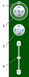
Google Earth navigation controls offer the same type of navigation action that you can achieve with mouse navigation. In addition, you can use the controls to zoom and swoop (perhaps for a perspective on terrain) or to rotate your view. The following diagram shows the controls and explains their functions.
New Navigation Controls

Click the north up button to reset the view so that north is at the top of the screen. Click and drag the ring to rotate your view.
Use the Look joystick to look around from a single vantage point, as if you were turning your head. Click an arrow to look in that direction or continue to press down on the mouse button and drag to change your view.
Use the Move joystick to move your position from one place to another. Click an arrow to move in that direction or continue to press down on the mouse button and drag to move.
Use the zoom slider to zoom in or out (+ to zoom in, - to zoom out). Double-click the icons at the end of the slider to reset the zoom all the way in or out. As you move closer to the ground, Google Earth swoops (tilts) to change your viewing angle to be parallel to the Earth's surface.
You can also use the keyboard to control navigation. See 3D Viewer Navigation in Keyboard Controls for more information.


  • Imagery Dates - You will now be able to easily see the dates when imagery was taken for most imagery (but, not all).

  • More 3D buildings, faster loading - Faster loading the 3D building models.

  • New photo-textured cities.

  • Day/Night Lighting - Real-time sunlight lighting option. Daylight/Time slider control of the sun's shadow position across the globe.

  • New Languages Support - even UK English!

Source:

http://earth.google.com/intl/en_uk/userguide/v4/

Download Google Earth 4.3

Labels: , , , , , ,

14 April 2008

Shapefile Overlay in Virtual Earth

15/04/2008
The Official Virtual Earth Blog picked up the this post and there 'maybe' potential for Virtual Earth to support ESRI Shapefiles in future edtions of Virtual Earth...(v6.2 please).
Read the post.
http://virtualearth.spaces.live.com/blog/cns!2BBC66E99FDCDB98!14450.entry
(add a comment to include this support)

Shapefile Overlay in Virtual Earth


A nice little application to display ESRI Shapefiles in Virtual Earth (Live Maps)

Highlight - Load from your local drive - takes a few moments.
**Your data needs to be in WGS84 for this to work correctly.

Virtual Earth Overlay Shapefiles
London Low Emissions Zones (LEZ) Shapefile was projected from British National Grid to WGS84.

Virtual Earth Overlay Shapefiles - Zoomed in
When you zoom in the detail is maintained, zoom out an a automatic poylgon generalisation is preformed on your data in the display.

Virtual Earth Overlay Shapefiles - 3D Mode
Your data can be rasterised 'on thefly' so it can be shown in 3D in Virtual Earth (Plugin required)

Suggestion - A Legend, possible to select your own colours.
A simple "6.1" on the end of the javascript code will update it to VE 6.1 (more functions)
"http://dev.virtualearth.net/mapcontrol/mapcontrol.ashx?v=6.1"


A progess bar when uploading from shapefile - FireFox can bail out with an error.

Select .shp only on upload - .dbf and .shx need to exist for a shapefile. Select.zip?

Load .avl or .lyr for thematic maps?

But other than that - if you want to view data in VE quickly then is a good method.

Well done to JuanDoNeblo & Marco Anastasi

source code see the code and details on how this was achieved.
http://geekswithblogs.net/JuanDoNeblo/Default.aspx

Mapperz

Labels: , , , , ,

31 March 2008

3D Geology Maps

3D Geology Maps using Virtual Earth


Geology Maps Available (US only)

Arizona Grand Canyon NP

Colorado (western half)

Utah (state level)

Washington State (state level)

http://www.3dgeomaps.com/ (3D-plugin required to view in 3D)

Future of Virtual Earth?

There is some impressive functions and new features coming to Virtual Earth very soon.

Microsoft is storing 15 PetaBytes of data that is used with Virtual Earth. (a lot)
The next VE release is April (due 10th April 2008)

  • "Enhanced experiences with bird's eye view in 3D, and new bird's eye hybrid view..."
  • Reverse geocoding for U.S. users.
  • Walking directions for North America and European Union users.
  • Traffic-based driving directions.
  • New cross-browser support.
  • Improved printing support for maps.

Sources:

http://www.nateirwin.net/VirtualEarth61BringsMoreFeatures.aspx

http://www.liveside.net/blogs/main/archive/2008/03/19/virtual-earth-at-mix08-with-silverlight-and-seadragon.aspx

Compatiablity with Virtual Earth + Silverlight
Virtual Earth + Silverlight + Seadragon
MS VE Silverlight 2.0 Beta SDK coming soon

Labels: , , , , , ,

05 March 2008

OpenSpace Tiles in Google Earth

update: 38 second clip on You Tube by request - video capture by SnagIT

OpenSpace Tiles in Google Earth

"Gavin Brock has produced an Ordnance Survey Overlay for Google Earth which enables you to view public footpaths in Google Earth. Unfortunately the kml of the overlay doesn’t appear to work when loaded into Google Maps." Google Maps Mania

Not sure on the legal aspects (OS Copyright) on this but it is impressive to see 1:50,000 Landranger Series in 3D. Some footpaths are available but 1:25,000 (Explorer Series) is the official scale for public footpaths and rights of way, currently 1:25,000 is not available in the Openspace API.

Labels: , , ,

10 February 2008

Carmenta Mobile (N95)

Carmenta Mobile
'The future of maps in mobile phones'


"Carmenta Mobile is a high performance map engine for mobile phones, targeting companies that want to provide advanced Location Based Services applications around maps, routing and geocoding"

Carmenta Mobile can be easily embedded into a mobile application as it provides a rich set of features such as:

  • 2D and 3D maps with 3D buildings and landmarks
  • Onboard and/or offboard (loaded from server) maps
  • Maps as images or vector data
  • In-car personal navigation
  • Pedestrian personal navigation
  • Friend finder
  • Proximity search, “where is the closest restaurant from my location”
  • Location based games
  • Tracking
  • Fleet management

video: http://www.youtube.com/watch?v=iBGvkmmSkWI

http://www.carmenta.com/company is a company producing high-class geospatial software products.

Labels: , , , , ,